


Summary
Little Wigborough is a village and former civil parish, now in the parish of Great and Little Wigborough, in the Colchester borough of Essex, England and forms part of Winstred Hundred Parish Council.[1] Little Wigborough is located between Peldon and Great Wigborough. In 1951 the parish had a population of 45.[2]
| Little Wigborough | |
|---|---|
 St Nicholas's church | |
 Little Wigborough Location within Essex | |
| Civil parish | |
| District | |
| Shire county | |
| Region | |
| Country | England |
| Sovereign state | United Kingdom |
History edit
The place-name 'Wigborough' is first attested in the Domesday Book of 1086, where it appears as Wicgebergha and Wigheberga. Little Wigborough is first referred to in the Valuation of Norwich of 1254, where it appears as Wigeberwe Parva. The name means 'Wicga's hill or barrow'.[3]
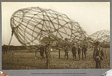
In the early hours of 24 September 1916, the German Army Zeppelin L33 was returning from a bombing raid on London, when it hit by an anti-aircraft shell and further damaged by Royal Flying Corps aircraft. It made a forced landing in the village, close to New Hall farm. The crew tried to burn the wreckage but they were only partially successful. They were arrested by the local special constable as they walked away from the scene.[4] A pen drawing with pencil of the Zeppelin by the Scottish artist Adam Bruce Thomson is on display at the Scottish National Portrait Gallery.[5]
On 1 April 1953 the parish was abolished and merged with Great Wigborough to form "Great and Little Wigborough".[6]
Church edit
The parish church is dedicated to St Nicholas.[7] It is a Grade II* listed building dating from the 15th century [8] but its list of rectors goes back to 1272.[9]
The building was badly damaged in the 1884 Colchester earthquake but extensive repairs were made. Time has taken its toll however: it is currently closed and is unlikely to reopen without funding. There are cracks inside and out and the extreme weather of recent years has caused subsidence in the south-west buttress and walls. The floor has sunk in some places and raised up in others.[10]
Geography edit
Most of Little Wigborough’s official village area is Copt Hall Marshes, a marshland and National Trust Nature Reserve to the south of the village. [11] The village boundary stretches to the north up to Abberton Reservoir. However, it does also have an exclave, to the west of the village, which includes Maldon Road and stretches to Salcott Creek in the south. The reasons for this exclave are unknown. [12]
References edit
- ^ "Home". winstred100.org.
- ^ "Population statistics Little Wigborough AP/CP through time". A Vision of Britain. Retrieved 10 October 2020.
- ^ Eilert Ekwall, The Concise Oxford Dictionary of English Place-names, p.517.
- ^ Colchester Metal Detecting Club: Zeppelin L33 Crashes in Lt Wigborough
- ^ National Portrait Gallery - Remembering the Great War [1] Retrieved 1 December 2014
- ^ "Relationships and changes Little Wigborough AP/CP through time". A Vision of Britain through Time. Retrieved 10 October 2020.
- ^ "Little Wigborough: St Nicholas".
- ^ Historic England. "CHURCH OF ST NICHOLAS (1223007)". National Heritage List for England. Retrieved 7 June 2014.
- ^ "Mersea MuseumL Little Wigborough".
- ^ "Little Wigborough: St Nicholas".
- ^ Copt Hall Marshes - Essex - National Trust [2] Retrieved 5 February 2023
- ^ Boundary Map of Little Wigborough AP/CP [3] Retrieved 5 February 2023
External links edit
- http://www.britishlistedbuildings.co.uk/search?q=Little+Wigborough
- https://merseamuseum.org.uk/mmwig.php - contains additional history of Great and Little Wigborough