


Summary
North Somerset is a unitary authority in the ceremonial county of Somerset, England. In the United Kingdom, the term listed building refers to a building or other structure officially designated as being of special architectural, historical or cultural significance; Grade I structures are those considered to be "buildings of exceptional interest".[1] Listing was begun by a provision in the Town and Country Planning Act 1947. Once listed, severe restrictions are imposed on the modifications allowed to a building's structure or its fittings. In England, the authority for listing under the Planning (Listed Buildings and Conservation Areas) Act 1990[2] rests with Historic England, a non-departmental public body sponsored by the Department for Digital, Culture, Media and Sport; local authorities have a responsibility to regulate and enforce the planning regulations.
North Somerset constitutes part of the ceremonial county of Somerset. As a unitary authority, North Somerset is administered independently of the non-metropolitan county of Somerset. Its administrative headquarters are located in the town hall of Weston-super-Mare. North Somerset includes areas that were once part of Somerset before the creation of Avon in 1974.[3]
There are 37 Grade I listed buildings in North Somerset, including the Clifton Suspension Bridge, which joins North Somerset to Bristol and Clevedon Pier. Of the listed buildings, manor houses include Clevedon Court, built in the 14th century, and from the 15th century, Ashton Court and Nailsea Court. Somerset has many religious structures; the largest number are from the Norman or medieval eras. Some of the churches are included in the Somerset towers, a collection of distinctive, mostly spireless Gothic church towers.
Buildings edit
| Name | Location | Type | Completed [note 1] | Grid ref.[note 2] Geo-coordinates |
Entry number [note 3] | Image | Ref. |
|---|---|---|---|---|---|---|---|
| All Saints Church | Wraxall | Parish Church | 12th century | ST4902171969 51°26′40″N 2°44′06″W / 51.444404°N 2.734914°W |
1158033 |  More images |
[4]
|
| Ashton Court mansion and stables | Long Ashton | Country House | 15th century | ST5570971837 51°26′38″N 2°38′19″W / 51.443781°N 2.638672°W |
1129841 |  More images |
[5] |
| Barn circa 50 metres north west of priory church | Kewstoke | Barn | 15th century | ST3429566203 51°23′28″N 2°56′45″W / 51.391046°N 2.945704°W |
1129768 |  More images |
[6]
|
| Church of All Saints | Kingston Seymour | Parish Church | Late 14th century | ST4008566849 51°23′51″N 2°51′45″W / 51.397496°N 2.86261°W |
1313027 |  More images |
[7]
|
| Church of All Saints | Wrington | Parish Church | 13th century | ST4678662718 51°21′40″N 2°45′56″W / 51.361024°N 2.765679°W |
1129227 |  More images |
[8] |
| Church of St Andrew | Backwell | Parish Church | 12th century | ST4931168330 51°24′42″N 2°43′49″W / 51.411713°N 2.730219°W |
1129810 |  More images |
[9] |
| Church of St Andrew | Banwell | Parish Church | 15th century | ST3994959133 51°19′41″N 2°51′48″W / 51.32811°N 2.863259°W |
1320659 | 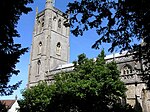 More images |
[10] |
| Church of St Andrew | Congresbury | Parish Church | 13th century | ST4356663762 51°22′12″N 2°48′44″W / 51.370099°N 2.812088°W |
1158046 | 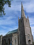 More images |
[11] |
| Church of St Andrew | Clevedon | Parish Church | 12th century | ST3937370828 51°25′59″N 2°52′25″W / 51.433193°N 2.873525°W |
1129692 |  More images |
[12] |
| Church of St Bridget | Chelvey | Parish Church | 12th century | ST4661868367 51°24′42″N 2°46′08″W / 51.411798°N 2.768943°W |
1129822 |  More images |
[13] |
| Church of St James | Winscombe | Parish Church | 13th century | ST4115256653 51°18′21″N 2°50′44″W / 51.305938°N 2.845585°W |
1320684 |  More images |
[14] |
| Church of St John the Baptist | Churchill | Parish Church | 12th century | ST4372960239 51°20′18″N 2°48′33″W / 51.338441°N 2.809188°W |
1157891 |  More images |
[15] |
| St Mary's Church | Portbury | Parish Church | 12th century | ST5029575432 51°28′32″N 2°43′01″W / 51.475653°N 2.717072°W |
1311826 |  More images |
[16] |
| Church of St Mary | Yatton | Parish Church | Late 13th century | ST4313165416 51°23′06″N 2°49′07″W / 51.384926°N 2.818601°W |
1137349 | 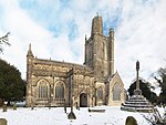 More images |
[17]
|
| Church of St Michael | Clapton in Gordano | Parish Church | 13th century | ST4677973536 51°27′30″N 2°46′03″W / 51.458286°N 2.767407°W |
1129088 |  More images |
[18] |
| Church of St Mary | Christon | Parish Church | 12th century | ST3795757287 51°18′41″N 2°53′29″W / 51.311299°N 2.891523°W |
1320668 |  More images |
[19]
|
| Church of St Michael | Dundry | Parish Church | 1484 | ST5575266859 51°23′56″N 2°38′15″W / 51.399027°N 2.63743°W |
1129078 | 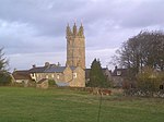 More images |
[20]
|
| Church of St Paul | Kewstoke | Parish Church | 12th century | ST3349563380 51°21′56″N 2°57′24″W / 51.365573°N 2.956671°W |
1303002 |  More images |
[21]
|
| Church of St Peter | Portishead | Parish Church | 14th century | ST4661776014 51°28′50″N 2°46′12″W / 51.48055°N 2.770113°W |
1291081 | 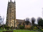 More images |
[22] |
| Church of St Peter & St Paul | Bleadon | Parish Church | 1317 | ST3414156909 51°18′27″N 2°56′46″W / 51.307471°N 2.946194°W |
1129064 |  More images |
[23]
|
| Church of St Peter & St Paul | Weston in Gordano | Parish Church | c. 1300 | ST4438074209 51°27′51″N 2°48′07″W / 51.464106°N 2.802038°W |
1129139 | 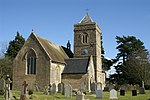 More images |
[24]
|
| Church of St Quiricus & St Julietta | Tickenham | Parish Church | 11th century | ST4577571446 51°26′22″N 2°46′54″W / 51.4394°N 2.781535°W |
1129121 | 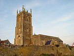 More images |
[25]
|
| Church of The Holy Saviour | Puxton | 15th century | ST4066663257 51°21′55″N 2°51′13″W / 51.365263°N 2.853658°W |
1156358 |  More images |
[26] | |
| Church of the Holy Trinity | Burrington | Parish Church | 15th century | ST4786459332 51°19′50″N 2°44′59″W / 51.330681°N 2.7497°W |
1129183 |  More images |
[27] |
| Church of the Holy Trinity | Nailsea | 15th century | ST4661069928 51°25′33″N 2°46′09″W / 51.425831°N 2.769293°W |
1136892 |  More images |
[28] | |
| Clevedon Court | Clevedon | Manor House | c. 1330 | ST4225971573 51°26′25″N 2°49′56″W / 51.440194°N 2.832135°W |
1136517 |  More images |
[29] |
| Clifton Suspension Bridge | Clifton in Bristol to Leigh Woods in North Somerset | Suspension Bridge | 1831 | ST5647873077 51°27′18″N 2°37′40″W / 51.45499°N 2.627761°W |
1205734 | 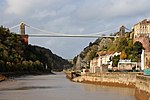 More images |
[30] |
| East cloister wall | Kewstoke | Remaining wall of cloisters. | 15th century | ST3435166154 51°23′26″N 2°56′42″W / 51.390612°N 2.94489°W |
1302945 |  |
[31] |
| Infirmary | Kewstoke | Infirmary | 15th century | ST3439066143 51°23′26″N 2°56′40″W / 51.390517°N 2.944328°W |
1156326 |  |
[32] |
| Nailsea Court | Nailsea | House | 15th century | ST4571068201 51°24′37″N 2°46′55″W / 51.410219°N 2.781972°W |
1129104 |  More images |
[33]
|
| Priory Church | Kewstoke | Priory Church | 15th and 16th century | ST3436166171 51°23′27″N 2°56′41″W / 51.390766°N 2.94475°W |
1320691 |  |
[34]
|
| The pier, including the tollhouse | Clevedon | Pier | 1869 | ST4008871939 51°26′36″N 2°51′48″W / 51.443258°N 2.863429°W |
1129687 |  More images |
[35]
|
| Gatehouse, gates, mounting block and wall running south for circa 20 metres | Kewstoke | Remains of gatehouse | 15th century | ST3433166158 51°23′26″N 2°56′43″W / 51.390645°N 2.945178°W |
1129767 |  |
[36]
|
| The Refectory and The Vicarage | Congresbury | Vicarage and former Priest's House, | 1446 | ST4360063797 51°22′14″N 2°48′42″W / 51.370417°N 2.811605°W |
1129203 |  More images |
[37]
|
| Tyntesfield house, servants wing and chapel | Wraxall | 1863 | ST5064671505 51°26′25″N 2°42′41″W / 51.440377°N 2.711469°W |
1129053 |  More images |
[38] | |
| West wall of chapter house range | Kewstoke | Wall | 15th century | ST3437266152 51°23′26″N 2°56′41″W / 51.390596°N 2.944588°W |
1320653 |  |
[39] |
See also edit
Notes edit
- ^ The date given is the date used by Historic England as significant for the initial building or that of an important part in the structure's description.
- ^ Sometimes known as OSGB36, the grid reference is based on the British national grid reference system used by the Ordnance Survey.
- ^ The "List Entry Number" is a unique number assigned to each listed building and scheduled monument by Historic England.
References edit
- ^ "Listed Buildings". Historic England. Retrieved 23 August 2017.
- ^ "Planning (Listed Buildings and Conservation Areas) Act 1990 (c. 9)". Ministry of Justice. Archived from the original on 18 April 2010. Retrieved 17 December 2007.
- ^ "The Avon (Structural Change) Order 1995". Her Majesty's Stationery Office. Archived from the original on 30 January 2008. Retrieved 9 December 2007.
- ^ Historic England. "All Saints Church (1158033)". National Heritage List for England. Retrieved 3 April 2015.
- ^ Historic England. "Ashton Court mansion and stables (1129841)". National Heritage List for England. Retrieved 3 April 2015.
- ^ Historic England. "Barn circa 50 metres north west of priory church (1129768)". National Heritage List for England. Retrieved 3 April 2015.
- ^ Historic England. "Church of All Saints (1313027)". National Heritage List for England. Retrieved 3 April 2015.
- ^ Historic England. "Church of All Saints (1129227)". National Heritage List for England. Retrieved 3 April 2015.
- ^ Historic England. "Church of St Andrew (1129810)". National Heritage List for England. Retrieved 3 April 2015.
- ^ Historic England. "Church of St Andrew (1320659)". National Heritage List for England. Retrieved 3 April 2015.
- ^ Historic England. "Church of St Andrew (1158046)". National Heritage List for England. Retrieved 3 April 2015.
- ^ Historic England. "Church of St Andrew (1129692)". National Heritage List for England. Retrieved 3 April 2015.
- ^ Historic England. "Church of St Bridget (1129822)". National Heritage List for England. Retrieved 3 April 2015.
- ^ Historic England. "Church of St James (1320684)". National Heritage List for England. Retrieved 3 April 2015.
- ^ Historic England. "Church of St John the Baptist (1157891)". National Heritage List for England. Retrieved 3 April 2015.
- ^ Historic England. "St Mary's Church (1311826)". National Heritage List for England. Retrieved 6 July 2015.
- ^ Historic England. "Church of St Mary (1137349)". National Heritage List for England. Retrieved 3 April 2015.
- ^ Historic England. "Church of St Michael (1129088)". National Heritage List for England. Retrieved 3 April 2015.
- ^ Historic England. "Church of St Mary (1320668)". National Heritage List for England. Retrieved 3 April 2015.
- ^ Historic England. "Church of St Michael (1129078)". National Heritage List for England. Retrieved 3 April 2015.
- ^ Historic England. "Church of St Paul (1303002)". National Heritage List for England. Retrieved 3 April 2015.
- ^ Historic England. "Church of St Peter (1291081)". National Heritage List for England. Retrieved 3 April 2015.
- ^ Historic England. "Church of St Peter & St Paul (1129064)". National Heritage List for England. Retrieved 6 July 2015.
- ^ Historic England. "Church of St Peter & St Paul (1129139)". National Heritage List for England. Retrieved 6 July 2015.
- ^ Historic England. "Church of St Quiricus & St Julietta (1129121)". National Heritage List for England. Retrieved 6 July 2015.
- ^ Historic England. "Church of The Holy Saviour (1156358)". National Heritage List for England. Retrieved 3 April 2015.
- ^ Historic England. "Church of the Holy Trinity (1129183)". National Heritage List for England. Retrieved 3 April 2015.
- ^ Historic England. "Church of the Holy Trinity (1136892)". National Heritage List for England. Retrieved 3 April 2015.
- ^ Historic England. "Clevedon Court (1136517)". National Heritage List for England. Retrieved 3 April 2015.
- ^ Historic England. "Clifton Suspension Bridge (1205734)". National Heritage List for England. Retrieved 3 April 2015.
- ^ Historic England. "East cloister wall (1302945)". National Heritage List for England. Retrieved 3 April 2015.
- ^ Historic England. "Infirmary (1156326)". National Heritage List for England. Retrieved 3 April 2015.
- ^ Historic England. "Nailsea Court (1129104)". National Heritage List for England. Retrieved 3 April 2015.
- ^ Historic England. "Priory Church (1320691)". National Heritage List for England. Retrieved 3 April 2015.
- ^ Historic England. "The pier, including the tollhouse (1129687)". National Heritage List for England. Retrieved 3 April 2015.
- ^ Historic England. "Gatehouse, gates, mounting block and wall running south for circa 20 metres (1129767)". National Heritage List for England. Retrieved 3 April 2015.
- ^ Historic England. "The Refectory and The Vicarage (1129203)". National Heritage List for England. Retrieved 3 April 2015.
- ^ Historic England. "Tyntesfield house, servants wing and chapel (1129053)". National Heritage List for England. Retrieved 3 April 2015.
- ^ Historic England. "West wall of chapter house range (1320653)". National Heritage List for England. Retrieved 3 April 2015.
External links edit