


Summary
Honshu (本州, Honshū, pronounced [hoꜜɰ̃ɕɯː] ⓘ; lit. 'main island'), historically called Akitsushima (秋津島, lit. 'Dragonfly island'),[3][4][5] is the largest and most populous island of Japan.[6][7] It is located south of Hokkaidō across the Tsugaru Strait, north of Shikoku across the Inland Sea, and northeast of Kyūshū across the Kanmon Straits. The island separates the Sea of Japan, which lies to its north and west, from the North Pacific Ocean to the south and east. It is the seventh-largest island in the world, and the second-most populous after the Indonesian island of Java.[8][9][10]
Native name: 本州 | |
|---|---|
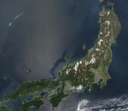 A May 2003 satellite image of Honshu | |
 | |
| Geography | |
| Location | Japanese archipelago |
| Coordinates | 36°N 138°E / 36°N 138°E |
| Archipelago | Japanese archipelago |
| Area | 227,960[1] km2 (88,020 sq mi) |
| Area rank | 7th |
| Length | 1,300 km (810 mi) |
| Width | 50–230 km (31–143 mi) |
| Coastline | 10,084 km (6265.9 mi) |
| Highest elevation | 3,776 m (12388 ft) |
| Highest point | Mount Fuji |
| Administration | |
| Prefectures | |
| Largest settlement | |
| Demographics | |
| Population | 104,000,000[2] (2017) |
| Pop. density | 447/km2 (1158/sq mi) |
| Ethnic groups | Japanese |
| Additional information | |
| Time zone | |
Honshu had a population of 104 million as of 2017[update], constituting 81.3% of the entire population of Japan,[11] and mostly concentrated in the coastal areas and plains. Approximately 30% of the total population resides in the Greater Tokyo Area on the Kantō Plain. As the historical center of Japanese cultural and political power,[12] the island includes several past Japanese capitals, including Kyōto, Nara, and Kamakura. Much of the island's southern shore forms part of the Taiheiyō Belt, a megalopolis that spans several of the Japanese islands.[12] Honshu contains Japan's highest mountain, Mount Fuji, and its largest lake, Lake Biwa.[13]
Most of Japan's industry is located in a belt running along Honshu's southern coast, from Tokyo to Nagoya, Kyōto, Osaka, Kobe, and Hiroshima;[12] by contrast, the economy along the northwestern Sea of Japan coast is largely based on fishing and agriculture.[14] The island is linked to the other three major Japanese islands by a number of bridges and tunnels. The island primarily shares two climates, with Northern Honshu having a mainly humid continental climate while the south has a humid subtropical climate.[15]
Etymology edit
The name of the island, Honshū (本州), directly translates to "main province" or "original land" in English.
History edit
Early history edit
Humans first arrived in Honshu approximately 37,000 years ago, and likely earlier. The first humans to arrive in Honshu were stone age hunter-gatherers from Northeast Asia, likely following the migration of ice age megafauna. Surviving artifacts from this time period include finely-crafted stone blades, similar to those found in Siberia.[16]
Meiji Restoration edit
World War II edit
Honshu was the target of devastating air raids during the Pacific War of World War II. The first air raid to strike Honshu and the other home islands was the Doolittle Raid. With the introduction of the Boeing B-29 Superfortress, the firebombing of Tokyo culminated in Operation Meetinghouse, the most destructive air raid in human history, which destroyed 16 square miles (41 km2; 10,000 acres) of central Tokyo, leaving an estimated 100,000 civilians dead, and over one million homeless.[17] The war ended with the atomic bombings of Hiroshima and Nagasaki shortly before Japan's surrender and signing of the Japanese Instrument of Surrender on September 2, 1945, on board the USS Missouri (BB-63) in Tokyo Bay.
Geography edit

The island is roughly 1,300 km (810 mi) long and ranges from 50 to 230 km (31 to 143 mi) wide, and its total area is 227,960 km2 (88,020 sq mi),[1] making it slightly larger than the island of Great Britain. Its land area has been increasing with land reclamation and coastal uplift in the north due to plate tectonics with a convergent boundary. Honshu has 10,084 kilometres (6,266 mi) of coastline.[7]
Mountainous and volcanic, Honshu experiences frequent earthquakes (Such as the Great Kantō earthquake, which heavily damaged Tokyo in September 1923; and the earthquake of March 2011, which moved the northeastern part of the island by varying amounts of as much as 5.3 m (17 ft)[18][19] while causing devastating tsunamis). The highest peak is the active volcano Mount Fuji at 3,776 m (12,388 ft), which makes Honshu the world's 7th highest island. There are many rivers, including the Shinano River, Japan's longest. The Japanese Alps span the width of Honshu, from the 'Sea of Japan' coast to the Pacific shore. The climate is generally humid subtropical in western Japan and humid continental in the north.
Population edit
Honshu has a total population of 104 million people, according to a 2017 estimate, 81.3% of the entire population of Japan.[11] The largest city is Tokyo (population: 13,988,129),[20] the capital of Japan and part of the Greater Tokyo Area, the most populous metropolitan area in the world.
Extreme points edit
Bridges and tunnels edit
Honshu is connected to the islands of Hokkaidō, Kyūshū and Shikoku by tunnels and bridges. Three bridge systems have been built across the islands of the Inland Sea between Honshu and Shikoku (Akashi Kaikyo Bridge and the Ōnaruto Bridge; Shin-Onomichi Bridge, Innoshima Bridge, Ikuchi Bridge, Tatara Bridge, Ōmishima Bridge, Hakata–Ōshima Bridge, and the Kurushima Kaikyō Bridge; Shimotsui-Seto Bridge, Hitsuishijima Bridge, Iwakurojima Bridge, Yoshima Bridge, Kita Bisan-Seto Bridge, and the Minami Bisan-Seto Bridge), the Seikan Tunnel connects Honshu with Hokkaidō, and the Kanmonkyo Bridge and Kanmon Tunnel connects Honshu with Kyūshū.
Flora and fauna edit
These are notable flora and fauna of Honshu.
Notable flora and fauna[21] Name Type Notes Japanese black bear Fauna A subspecies of the Asian black bear. It is typically herbivorous and lives in Honshu and Kyushu. Japanese macaque Fauna (Macaca fuscata or snow monkey), is a terrestrial Old World monkey species that is native to Japan. Japanese golden eagle Fauna (Aquila chrysaetos japonica), a subspecies of the golden eagle, inhabits Honshu and Hokkaido all year round. Japanese wolf Fauna Aka Honshu Wolf is an extinct subspecies of the wolf. Sika Deer Fauna Cervus nippon (Japanese deer), is overabundant in Honshu. Japanese dwarf flying squirrel Fauna (Nihon momonga) is one of two species of Old World flying squirrels in the genus Pteromys. Japanese raccoon dog Fauna (Nyctereutes viverrinus, also called tanuki), is a species of canid endemic to Japan. Japanese giant salamander Fauna (Andrias japonicus) this fully aquatic salamander is endemic to Japan and called Ōsanshōuo (Giant Salamander) Takydromus tachydromoides Fauna The Japanese grass lizard, is a wall lizard species of the genus Takydromus. Japanese serow Fauna (kamoshika, lit. "coarse pelt deer"): (Capricornis crispus) is a Japanese goat-antelope found in dense woodland primarily in northern and central Honshu. Japanese giant flying squirrel Fauna (musasabi, Petaurista leucogenys) is native to Japan where it inhabits sub-alpine forests and boreal evergreen forests on Honshu, Shikoku and Kyushu. Japanese boar Fauna (Sus scrofa leucomystax, aka white-moustached pig, Nihon-inoshishi (ニホンイノシシ)), is a subspecies of wild boar native to all of Japan, save for Hokkaido and the Ryukyu Islands. Japanese bush warbler Fauna (uguisu (鶯), is an Asian passerine bird more often heard than seen. It is a year-round resident of Japan (except Hokkaido where it is only in summer). Sasakia charonda Fauna National butterfly of Japan (ō-murasaki, "great purple") Copper pheasant Fauna (Syrmaticus soemmerringii) a large pheasant with a rich coppery chestnut plumage is endemic to Japan. Green pheasant Fauna (Phasianus versicolor), aka Japanese green pheasant, is an omnivorous bird native to the Japanese archipelago, to which it is endemic. Grey Heron Fauna (Ardea cinerea) Long legged wading bird. Japanese scops owl Fauna (Otus semitorques) is a resident breeder in Japan and found in other countries in East Asia. Doryrhamphus japonicus Fauna Doryrhamphus japonicus, or the Honshu pipefish, is a species of flagtail pipefish Brahmaea japonica Fauna (Japanese owl moth) a species of moth of the Brahmaeidae family native to Japan. Japanese spider crab Fauna (Macrocheira kaempferi) a marine crab with the largest leg-span of any arthropod. They live off the southern coasts of Honshū from Tokyo Bay to Kagoshima Prefecture. Chum salmon Fauna (aka white salmon (白鮭 シロサケ) is native to middle and northern Honshu, Hokkaido and the North Pacific. Silurus biwaensis Fauna The giant Lake Biwa catfish or Biwako-o'namazu, endemic to Lake Biwa. Oncorhynchus kawamurae Fauna A species of landlocked Pacific trout in Japan. It is endemic to Lake Tazawa, Akita Prefecture, but was translocated to Lake Saiko. Akita Inu Fauna (秋田犬, Akita-inu) is a historic dog breed of large size originating from the mountains in Akita Prefecture (northern Honshu). Kai Ken Fauna The Kai Ken (甲斐犬) is a rare breed of dog native to Japan. It is originally from Kai Province in Yamanashi Prefecture. Kishu Fauna Kishu Ken are a rare dog breed that was selectively bred for the hunting of wild boar and deer in the mountainous Mie prefecture and Wakayama prefecture. Shiba Inu Fauna The Shiba Inu (柴犬), is an original and distinct spitz breed hunting dog, native to Japan. Japanese rose Flora (Rosa rugosa), a species of rose native to eastern Asia and Japan. Hydrangea hirta Flora A species of flowering plant in the family Hydrangeaceae that is native to East Asia and common in the Pacific side of Honshu. Tsuga sieboldii Flora (Tsuga sieboldii or simply tsuga (栂)), is a conifer native to the Japanese islands of Honshū, Kyūshū, Shikoku and Yakushima.
Geologic activity edit
Being on the Ring of Fire, the island of Honshu is seismically active, and is home to 40 active volcanoes.
In 2011, an earthquake of magnitude 9.0–9.1 occurred off the coast of Honshu, generating tsunami waves up to 40.5 meters (133 ft) high and killing 19,747. It was the most powerful earthquake ever recorded in Japan, and the fourth most powerful earthquake in the world since modern record-keeping began in 1900.[22][23][24] The tsunami subsequently led to the meltdown of 3 nuclear reactors at the Fukushima Daiichi Nuclear Power Plant, leading to the Fukushima nuclear disaster.
Parks edit

| Minami Alps National Park | 南アルプス |
| Chūbu-Sangaku National Park | 中部山岳 |
| Hakusan National Park | 白山 |
| Myōkō-Togakushi Renzan National Park | 妙高戸隠連山 |
| Daisen-Oki National Park | 大山隠岐 |
| Chichibu Tama Kai National Park | 秩父多摩甲斐 |
| Fuji-Hakone-Izu National Park | 富士箱根伊豆 |
| Jōshin'etsu-kōgen National Park | 上信越高原 |
| Nikkō National Park | 日光国立公園 |
| Ogasawara National Park | 小笠原 |
| Ise-Shima National Park | 伊勢志摩 |
| Sanin Kaigan National Park | 山陰海岸 |
| Yoshino-Kumano National Park | 吉野熊野 |
| Setonaikai National Park | 瀬戸内海 |
| Bandai-Asahi National Park | 磐梯朝日 |
| Sanriku Fukkō National Park | 三陸復興 |
| Towada-Hachimantai National Park | 十和田八幡平 |
| Oze National Park | 尾瀬 |
Economy edit
Honshu island generates around US$3.5 trillion or more than 80% of Japan's GDP.[25]
Agriculture edit
Fruit, vegetables, grains, rice and cotton make up the main produce grown in Honshu.[26] The Tohoku region, spanning the north-eastern part of the island, is notable for its rice production, with 65% of cultivated land being rice paddy fields – almost a quarter of all paddy fields in Japan.[27] Chiba Prefecture is famous for its peanuts, also being the largest producer in Japan.[28] Rare species of the lichen genus Menegazzia are found only in Honshu.[29]
Industry edit
Most of Japan's tea and silk is from Honshu.[26] Japan's three largest industrial regions are all located on Honshu: the Keihin region, the Hanshin Industrial Region, and the Chūkyō Industrial Area.
Minerals and fuels edit
Honshu is home to a large portion[30] of Japan's minimal mineral reserves,[31] including small oil and coal deposits. Several coal deposits are located in the northern part of the island,[32] concentrated in Fukushima Prefecture and Niigata Prefecture, though Honshu's coal production is negligible in comparison to Hokkaido and Kyushu.[33] Most of Japan's oil reserves are also located in northern Honshu, along the west coast, spanning Niigata, Yamagata, and Akita Prefectures.[34]
Most of Japan's copper, lead, zinc and chromite is located on Honshu, along with smaller, scattered deposits of gold, silver, arsenic, sulfur and pyrite.[35]
Transportation edit
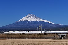
The Tokaido Shinkansen, opened in 1964 between Tokyo and Shin-Ōsaka, is Japan's first high-speed rail line.[36] It is the world's oldest high-speed rail line and one of the most heavily used.[37][38] The San'yō Shinkansen, connects the two largest cities in western Japan, Shin-Osaka in Osaka with Hakata Station in Fukuoka. Both the Tokaido Shinkansen and the Sanyo Shinkansen help form a continuous high-speed railway through the Taiheiyō Belt megalopolis.
Administrative regions and prefectures edit
The island is divided into five nominal regions and contains 34 prefectures, including metropolitan Tokyo. Administratively, some smaller islands are included within these prefectures, notably including the Ogasawara Islands, Sado Island, Izu Ōshima, and Awaji Island.
The regions and their prefectures are:
- Tōhoku region consists of six prefectures.
- Kantō region consists of seven prefectures, including the capital of Japan which is the Tokyo Metropolis.
- Chūbu region consists of nine prefectures.
- Kansai region consists of seven prefectures.
- Chūgoku region consists of five prefectures.
See also edit
References edit
- ^ a b Farjon, Aljos; Filer, Denis (2013). An Atlas of the World's Conifers: An Analysis of their Distribution, Biogeography, Diversity and Conservation Status. BRILL. p. 268. ISBN 9789004211810.
- ^ a b "Tokyo Metropolis' Population overview – Reiwa 3 January 1" (in Japanese). Tokyo Metropolitan Government. Retrieved October 22, 2021.
- ^ "Maps ETC - Asia -> Japan". University of South Florida. Retrieved 25 June 2023.
- ^ "Ōyamatotoyoakizushima". Kokugakuin University. Retrieved 29 June 2023.
- ^ "Akitsushima". Isahaya Shrine. Retrieved 29 June 2023.
- ^ "離島とは(島の基礎知識) (what is a remote island?)". MLIT (Ministry of Land, Infrastructure, Transport and Tourism) (in Japanese). Ministry of Land, Infrastructure, Transport and Tourism. 22 August 2015. Archived from the original (website) on 2007-11-13. Retrieved 9 August 2019.
MILT classification 6,852 islands(main islands: 5 islands, remote islands: 6,847 islands)
- ^ a b "Honshu". Encyclopædia Britannica. Retrieved 19 February 2016.
- ^ Japan Civil Registry Database 2013
- ^ See Japan Census of 2000; the editors of List of islands by population appear to have used similar data from the relevant statistics bureaux and totalled up the various administrative districts that make up each island, and then done the same for less populous islands. An editor of this article has not repeated that work. Therefore this plausible and eminently reasonable ranking is posted as unsourced common knowledge.
- ^ "Islands By Land Area". Islands.unep.ch. Archived from the original on 2018-02-20. Retrieved 2010-08-01.
- ^ a b Boquet, Yves (2017). The Philippine Archipelago. Springer. p. 16. ISBN 9783319519265.
- ^ a b c Dolan, Ronald; Worden, Robert (1992). Japan: a country study. Federal Research Division, Library of Congress.
- ^ "Honshu | Facts, History, & Points of Interest". Encyclopedia Britannica. Retrieved 2021-04-14.
- ^ Kodansha Encyclopedia of Japan
- ^ Köppen, Wladimir (1884). "Die Wärmezonen der Erde, nach der Dauer der heissen, gemässigten und kalten Zeit und nach der Wirkung der Wärme auf die organische Welt betrachtet" [The thermal zones of the earth according to the duration of hot, moderate and cold periods and to the impact of heat on the organic world)] (PDF). Meteorologische Zeitschrift. 20 (3). Translated by Volken, E.; Brönnimann, S (published 2011): 351–360. Bibcode:2011MetZe..20..351K. doi:10.1127/0941-2948/2011/105. S2CID 209855204. Retrieved 2016-09-02 – via ingentaconnect.com/content/schweiz/mz/2011/00000020/00000003/art00009.
- ^ "About Japan: A Teacher's Resource | Early Japan (50,000 BC - 710 AD) | Japan Society".
- ^ Long, Tony (9 March 2011). "March 9, 1945: Burning the Heart Out of the Enemy". Wired.
1945: In the single deadliest air raid of World War II, 330 American B-29s rain incendiary bombs on Tokyo, touching off a firestorm that kills upwards of 100,000 people, burns a quarter of the city to the ground, and leaves a million homeless.
- ^ "Map of Horizontal Land Movement caused by 2011/3/11 M9.0 earthquake" (PDF) (in Japanese). Geospatial Information Authority of Japan. March 19, 2011. Retrieved 15 November 2012.
- ^ "Quake shifted Japan by over two meters". Deutsche Welle. March 14, 2011. Retrieved March 14, 2011.
- ^ "Tokyo Population 2021 (Demographics, Maps, Graphs)". worldpopulationreview.com. Retrieved 2021-10-22.
- ^ Japanese Wiki page ja:北海道
- ^ "New USGS number puts Japan quake at fourth largest". CBS News. Associated Press. 14 March 2011. Archived from the original on 7 April 2011. Retrieved 15 March 2011.
- ^ Branigan, Tania (13 March 2011). "Tsunami, earthquake, nuclear crisis – now Japan faces power cuts". The Guardian. London. Archived from the original on 11 June 2022. Retrieved 15 March 2011.
- ^ "Japan quake – seventh largest in recorded history". 11 March 2011. Archived from the original on 31 March 2011. Retrieved 11 March 2011.
- ^ Regions and Cities > Regional Statistics > Regional Economy > Gross Domestic Product, Large regions TL2, OECD.Stats. Accessed on 30 August 2022.
- ^ a b "Honshu". infoplease.com. 2012. Retrieved 2014-11-23.
- ^ "Regions of Japan" (PDF). Web Japan. Retrieved 2021-10-22.
- ^ "Peanuts | Authentic Japanese product". japan-brand.jnto.go.jp. Retrieved 2021-10-22.
- ^ Bjerke JW (2004). "Revision of the lichen genus Menegazzia in Japan, including two new species". The Lichenologist. 36 (1): 15–25. doi:10.1017/S0024282904013878. ISSN 0024-2829. S2CID 85436634.
- ^ Natural Resources of Japan. General Headquarters, Supreme Commander for the Allied Powers, Natural Resources Section. 1947. pp. 42–48.
- ^ "Japan – Resources and power". Encyclopedia Britannica. Retrieved 2021-10-22.
- ^ "Catalogue of Geological Maps|Geological Survey of Japan/ AIST". www.gsj.jp. Retrieved 2021-10-22.
- ^ Natural Resources of Japan. General Headquarters, Supreme Commander for the Allied Powers, Natural Resources Section. 1947. p. 44.
- ^ Natural Resources of Japan. General Headquarters, Supreme Commander for the Allied Powers, Natural Resources Section. 1947. p. 43.
- ^ Natural Resources of Japan. General Headquarters, Supreme Commander for the Allied Powers, Natural Resources Section. 1947. pp. 44–45.
- ^ "Shinkansen – Bullet Trains in Japan". Trainspread.com. 2020. Archived from the original on March 21, 2020.
- ^ Kasai, Yoshiyuki (4 September 2010). "Bullet Train & Maglev System to Cross the Pacific". Envoy Media. Archived from the original on 31 March 2012. Retrieved 16 July 2022.
- ^ "Central Japan Railway Company". Central Japan Railway Company (in Japanese). Retrieved 2022-07-16.
External links edit
 Honshu travel guide from Wikivoyage
 Media related to Honshu at Wikimedia Commons