


Summary
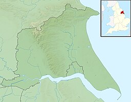
Hornsea Mere is the largest freshwater lake in Yorkshire,[1] England, and lies to the west of Hornsea in the East Riding of Yorkshire.[2] The mere was used as a base for the Royal Naval Air Service and then latterly, the Royal Air Force during the First World War.
| Hornsea Mere | |
|---|---|
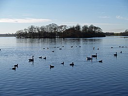 Swan Island, Hornsea Mere | |
 Hornsea Mere | |
| Location | Southgate, Hornsea, East Riding of Yorkshire |
| Coordinates | 53°54′20″N 0°11′10″W / 53.90556°N 0.18611°W |
| Basin countries | United Kingdom |
| Max. length | 2 miles (3.2 km) |
| Max. width | 0.75 miles (1.2 km) |
| Surface area | 467 acres (1.89 km2) |
| Max. depth | 12 feet (3.7 m) |
| Surface elevation | 26 feet (8 m) |
Description edit
It covers an area of 467 acres (1.89 km2), is 2 miles (3.2 km) long, 0.75 miles (1.2 km) at its widest point and 12 feet (3.7 m) at its deepest.[3][4] The average depth of the lake is 4 feet 11 inches (1.5 m) and the mere itself lies only 26 feet (8 m) above sea level.[5] The mere is fed by several small streams and a sluice gate at the eastern end of the mere controls the outflow, which travels only 0.68 miles (1.1 km) eastwards to the North Sea.[6][7]
Hornsea Mere is a centre for bird-watching and a tourist attraction offering rowing, sailing, boat trips and fishing. It is a designated Site of Special Scientific Interest and a Special Protection Area for birds;[8] it accommodates many species throughout the year, and is of international importance for a migratory population of gadwall.[6] Its shallowness results in a diverse range of swamp and fen plants.
It was featured in the BBC television programme Seven Natural Wonders.[9]
Hornsea Mere is owned by Wassand Hall, situated to the west of the mere, and was purchased by the Hall's estate for £50 in the 16th century.[10]
The mere is the base for Hornsea Sailing Club.[11]
RNAS Hornsea Mere edit
A Royal Naval Air Service seaplane base was opened on the mere in September 1917.[12] Initially, numbers 248 and 251 squadrons operated from RNAS Hornsea Mere with a headquarters at Killingholme. No. 251 Squadron operated non-water based aircraft so did not actually fly from Hornsea despite being based there.[13]
The RNAS base was located on Kirkholme Nab, a small 6-acre (2.4 ha) peninsula that sticks out westwards from the eastern shore. The RNAS installed two Bessonneau hangars and two slipways from Kirkholme Nab which allowed a dozen seaplanes to be operated from the base.[14][12] Various flights flew from here in coastal protection and submarine attack operations. These flights were eventually grouped together to form No. 248 Squadron who were commanded by No. 79 (Operations) Wing (who also commanded No. 251 Squadron, hence their allocation at Hornsea Mere).[15]
A number of brick buildings left behind by the RAF in 1919 are still in use today, employed by the boatyard and the cafe which operate there.[16][17] Despite being vacated by the RAF, the mere and the former RNAS buildings were used as a starting point for aerial practice runs on the bombing range at RAF Cowden on the East Yorkshire coast.[18]
References edit
- ^ "Special Protection Area - Hornsea Mere". Joint Nature Conservation Committee. 2001. Retrieved 27 July 2008.
- ^ "295" (Map). Bridlington, Driffield & Hornsea. 1:25,000. Explorer. Ordnance Survey. 2015. ISBN 9780319245477.
- ^ Winn, Christopher (2010). I never knew that about Yorkshire. London: Ebury. p. 38. ISBN 978-0-09-193313-5.
- ^ Chrystal, Paul (2017). The Place Names of Yorkshire; Cities, Towns, Villages, Rivers and Dales, some Pubs too, in Praise of Yorkshire Ales (1 ed.). Catrine: Stenlake. p. 105. ISBN 9781840337532.
- ^ "Hornsea Mere". environment.data.gov.uk. Retrieved 1 November 2018.
- ^ a b May, Linda; Spears, Brian; O'Malley, Michael (12 March 2010). "An assessment of nutrient sources and water quality improvement measures in Hornsea Mere" (PDF). nora.nerc.ac.uk. p. 5. Retrieved 1 November 2018.
- ^ "Hornsea Mere" (PDF). environment-agency.gov.uk. June 2016. p. 13. Retrieved 1 November 2018.
- ^ "Hornsea Mere" (PDF). designatedsites.naturalengland.org.uk. Retrieved 1 November 2018.
- ^ "Yorkshire and Lincolnshire - Hornsea Mere". Seven Wonders. BBC. Retrieved 24 September 2009.
- ^ "Cycle ride at Hornsea Mere". Gazette & Herald. 16 June 2011. Retrieved 27 June 2012.
- ^ "Hornsea Sailing Club". Hornsea Sailing Club. Retrieved 12 May 2010.
- ^ a b Chorlton 2014, p. 44.
- ^ Historic England. "RNAS Hornsea Mere (913357)". Research records (formerly PastScape). Retrieved 1 November 2018.
- ^ Halpenny, Bruce Barrymore (1982). Action stations 4: Military Airfields of Yorkshire (2 ed.). Cambridge: Patrick Stephens. p. 92. ISBN 0-85059-532-0.
- ^ Chorlton 2014, pp. 44–45.
- ^ Chorlton 2014, p. 45.
- ^ Brigham, T; Buglass, J; George, R (February 2008). "Rapid coastal zone assessment survey: Yorkshire and Lincolnshire" (PDF). historicengland.org.uk. p. 194. Retrieved 1 November 2018.
- ^ Delve, Ken (2006). Northern England : Co. Durham, Cumbria, Isle of Man, Lancashire, Merseyside, Manchester, Northumberland, Tyne & Wear, Yorkshire. Marlborough: Crowood Press. p. 294. ISBN 1-86126-809-2.
Sources edit
- Chorlton, Martyn (2014). Forgotten Aerodromes of World War I. Manchester: Crecy. ISBN 9780859791816.
External links edit
- "Hornsea Mere"; East Riding of Yorkshire Council. Retrieved 27 June 2012