


Summary
Ishwarganj (Bengali: ঈশ্বরগঞ্জ) is an administrative area in north-eastern Bangladesh. It is an upazila in Mymensingh District.
Ishwarganj
ঈশ্বরগঞ্জ | |
|---|---|
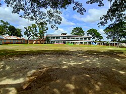 Mollikpur Laksmiganj High School | |
 | |
| Coordinates: 24°39′0″N 90°30′0″E / 24.65000°N 90.50000°E | |
| Country | |
| Division | Mymensingh |
| District | Mymensingh |
| Headquarters | Ishwarganj |
| Government | |
| • Type | Upazila Parishad |
| • Chairman | A. K. M. Faridullah |
| • MP (Mymensingh-8) | Mahmud Hasan Sumon |
| Area | |
| • Total | 280.43 km2 (108.27 sq mi) |
| Population (2011) | |
| • Total | 376,348 |
| • Density | 1,300/km2 (3,500/sq mi) |
| Time zone | UTC+6 (BST) |
| Postal code | 2280 |
| Website | iswarganj |
History edit
Bhulsoma Mosque was established in 1600, and the Naluapara Mosque in 1625.[1]
In 1936, Pitalganj was established as a thana. It was renamed to Ishwarganj in honour of boatman Ishwari Patni.[2] On 16 October 1971, during the Bangladesh Liberation War, six Bengali fighters were killed by Pakistani troops. Ishwarganj was liberated on 9 December 1971. The thana was upgraded to an upazila in 1983.
Geography edit
Ishwarganj has a total area of 280.43 km2.[1] It borders Gauripur Upazila to the north, Nandail Upazila to the south, Kendua Upazila to the east, and Trishal Upazila to the west. It is 147 km from Dhaka and 24 km from Mymensingh.
The Kanchamatia River flows through the upazila into the Narasunda River.
Demographics edit
According to the 2011 Bangladesh census, Ishwarganj Upazila had 81,070 households and a population of 376,348. 108,368 (28.79%) were under 10 years of age. Ishwarganj has a literacy rate (age 7 and over) of 41.01%, compared to the national average of 51.8%, and a sex ratio of 1010 females per 1000 males. 34,231 (9.10%) lived in urban areas.[4][3]
According to the 1991 Bangladesh census, Ishwarganj had a population of 306,977 in 56,296 households. 143,379 persons were aged 18 or older. Males constituted 50.8% of the population and females 49.2%. Ishwarganj has an average literacy rate of 22.2% (age 7+ years), compared to the national average of 32.4%.[5]
Points of interest edit
Nearby places of interest include the Atharabari Railway Station, Luxmigonj Bazar, Mizebag, Mirzapur, Tarundia, Uchakhila, Boro hit, Sohagi Railway Station and Uchakhila Bazar.
Atharabari has been known for its Rayerbazar for centuries.
Khalbala Bazar offers locally-made jute products.
Administration edit
Ishwarganj Upazila is divided into Ishwarganj Municipality and 11 union parishads: Atharabari, Barahit, Iswarganj, Jatia, Magtula, Maijbagh, Rajibpur, Sarisha, Sohagi, Tarundia, and Uchakhila. The union parishads are subdivided into 293 mauzas and 294 villages.[6]
Ishwarganj Municipality is subdivided into 9 wards and 13 mahallas.[6]
Ishwarganj's Member of the Parliament is Fakhrul Imam. Its Upazila Chairman is Mahmud Hasan Sumon. The Vice Chairman is Aminul Islam Bhuyan ( Moni ) [BNP]. The female Vice Chairman is Shefali Hamid. [BNP]. Its Upazila Nirbahi Officer (UNO) is Hafiza Jasmin.
List of chairmen edit
| Name |
|---|
| Ahmad Husayn Bhuiyan |
| Saumyendra Kishore Chowdhury |
| Mahmud Hasan Sumon |
Economy edit
The economy of the region centers on agriculture, accounting for 70.52% of income. 70,718 acres are under cultivation. Other sectors include business (10.22%) and services (3.84%).
Education edit
Ishwaraganj's educational institutes include:
- Ishwarganj Degree College[7]
- Ishwarganj Bisweswari Pilot High School[8]
- Abdul Khaleque Moksuda High School
- Uchakhila Higher Secondary School and college
- Ishwarganj Mohila College
- Atharabari College
- Alinogor Technical & Commercial College
- Atharabari M.C. High School
- Barohit High School
- Charjhithor High School
- Charnikhla High School
- Ishwargonj Ideal College
- Jatia High School
- Kasimpur High School
- Konapara High School
- Madhupur M.L. High School
- Maizbag Pas Para High School
- Mollik pur High School, (Laxmigonj)
- Moricharchor High School
- Postail High School
- Rajibpue AU High School
- Shakhua Adarsha Bidya Niketon High school
- Shohagi Union High School
- Tarundia Jagat Memorial High School
- Protishruti Model High School
- D.S. Kamil Madrasha
- Kazir Bolsha Dakhil Madrasha
- Mohespur Dakil Madrasha
- Pitambar Para Alia Madrasha, (Laxmigonj)
- Shakhwa Mozidia Dakhil Madrasha
- Uchakhila Keramotia S.A Madrasha
- Dhitpur High School
- Sree Nogor Dakhil Madrasha
- Rawlar Char Alim Madrasha
- Kumaruli High School
- Fanur Ashraful Ulom Dhakil Madrasha
- Madhupur abbasia DS Dhakil Madrasha
Notable people edit
- Abdul Hye Mashreki, litterateur, was born in Dattapara village in 1909.[9]
- Fakhrul Imam, politician
- Md. Abdus Sattar, parliamentarian
- Shah Nurul Kabir, politician
- Zainul Abedin, politician
See also edit
References edit
- ^ a b Md. Azizur Rahman Bhuiyan (2012). "Ishwarganj Upazila". In Sirajul Islam; Miah, Sajahan; Khanam, Mahfuza; Ahmed, Sabbir (eds.). Banglapedia: the National Encyclopedia of Bangladesh (Online ed.). Dhaka, Bangladesh: Banglapedia Trust, Asiatic Society of Bangladesh. ISBN 984-32-0576-6. OCLC 52727562. OL 30677644M. Retrieved 22 April 2024.
- ^ উপজেলা প্রশাসনের পটভূমি. Iswarganj Upazila (in Bengali).
- ^ a b "Bangladesh Population and Housing Census 2011 Zila Report – Mymensingh" (PDF). bbs.gov.bd. Bangladesh Bureau of Statistics.
- ^ "Community Tables: Mymensingh district" (PDF). bbs.gov.bd. 2011.
- ^ "Population Census Wing, BBS". Archived from the original on 2005-03-27. Retrieved November 10, 2006.
- ^ a b "District Statistics 2011: Mymensingh" (PDF). Bangladesh Bureau of Statistics. Archived from the original (PDF) on 13 November 2014. Retrieved 14 July 2014.
- ^ "Ishwarganj Degree College - ঈশ্বরগঞ্জ ডিগ্রী কলেজ". www.idc.edu.bd. Archived from the original on 2018-08-03. Retrieved 2020-01-26.
- ^ "::Welcome To Our Web Portal ::". www.bphs.edu.bd.
- ^ Ishaq, Muhammad, ed. (1978). Bangladesh District Gazetteers: Mymensingh. Bangladesh Government Press. p. 273. OCLC 708216.