


Summary
Jhang (جھنگ; Punjabi pronunciation: [ˈt͡ʃə̀ŋ.gᵊ]; Urdu pronunciation: [d͡ʒʱəŋɡ]) is the capital city of Jhang District in the central portion of the province of Punjab, Pakistan. Situated on the east bank of the Chenab river, it is the 18th largest city of Pakistan by population.[2]
Jhang
جھنگ | |
|---|---|
 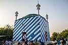  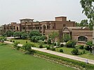 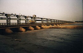 Clockwise from top:
Shrine of Sultan Bahoo; Shrine of Heer and Ranjha; Chenab College; Trimmu Barrage and Chenab Bridge | |
 Jhang Location of Jhang in Pakistan  Jhang Jhang (Pakistan) | |
| Coordinates: 31°16′10″N 72°18′58″E / 31.26944°N 72.31611°E | |
| Country | Pakistan |
| Province | Punjab |
| Division | Faisalabad |
| District | Jhang |
| Area | |
| • Total | 28.27 km2 (10.92 sq mi) |
| Population | |
| • Total | 414,131 |
| • Rank | 16th, Pakistan |
| • Density | 15,000/km2 (38,000/sq mi) |
| Time zone | UTC+5 (PST) |
| Postal code | 35200 |
| Calling code | 047 |
Etymology edit
The historical name of the city and district is Jhang Sial.[3] The word Jhang is derived from the Sanskrit word jāṅgala which means rough or forested terrain; the word Jungle also shares the same root. Jhang Sial was the historic name of the city, literally meaning the "terrain of the Sials".[3][4][5][6]
History edit
The city of Jhang was built in 1288 by Rai Sial, a chief of the Sial tribe.[4][6][3] The Sial tribe, his kin, ruled over this region ever since then until the last Sial ruler of Jhang, Ahmad Khan (1812 to 1822) was defeated by Ranjit Singh after a fierce fighting.[3][7]
Under the collective rule of the Sial Khans of Jhang and other Sial sub-tribes such as the Rajbana and Bharwana, in the zenith of their power, the Sial country of Jhang extended up to the Muzafargarh boundary in the south, and the entirety of Chiniot, Kamalia and Kabirwala ilakas. The territory extended to parts of Bhakkar and Sargodha. The Garh Mahraja and Ahmadpur Sial ilakas were added to the possessions of the Rajbana Sial tribe who drove out the Baloch tribes to the Thal and defeated the Nawab of Multan by the mid 17th century.[3][5]
Under the British Raj, the towns of Jhang and Mighiana, lying two miles (3.2 km) apart, became a joint municipality, then known as Jhang-Maghiana.[8]
Geography edit
Jhang Sadr is located at 31.27 latitude and 72.33 longitude and is situated at an elevation of 158 meters above sea level.
Jhang is situated at the East bank of Chenab which has confluence with Jhelum at Trimmu Barrage near the town of Athara Hazari. The city was endangered in the 2014 floods but it was not flooded as the flood water was redirected towards Athara Hazari.[9] there are three river in jhang such as chenab river jhelum river and river ravi is also touch with the boundary of District Jhang near Ahmadpur Sial. Maghiana lies on the edge of the highlands, overlooking the alluvial valley of the Chenab, while the older town of Jhang occupies the lowlands at its foot.[8]
Demographics edit
The population of city in 1998 Census of Pakistan was recorded as 293,366. According to the 2017 Census of Pakistan, the population of city rose to 414,131 with a growth of 41.17% in 19 years.[1]
| Religious group |
1881[11][12][13] | 1891[14]: 68 [15] | 1901[16]: 44 [17]: 26 | 1911[18]: 23 [19]: 19 | 1921[20]: 25 [21]: 21 | 1931[22]: 26 | 1941[10]: 32 | 2017[23] | ||||||||
|---|---|---|---|---|---|---|---|---|---|---|---|---|---|---|---|---|
| Pop. | % | Pop. | % | Pop. | % | Pop. | % | Pop. | % | Pop. | % | Pop. | % | Pop. | % | |
| Islam |
10,941 | 50.58% | 11,334 | 48.66% | 11,684 | 47.92% | 12,707 | 49.04% | 14,760 | 48.97% | 18,042 | 50.07% | 24,506 | 48.96% | 427,008 | 99.43% |
| Hinduism |
10,187 | 47.1% | 11,355 | 48.75% | 12,189 | 49.99% | 12,395 | 47.83% | 14,389 | 47.74% | 16,724 | 46.41% | 23,286 | 46.52% | 36 | 0.01% |
| Sikhism |
495 | 2.29% | 573 | 2.46% | 484 | 1.99% | 796 | 3.07% | 970 | 3.22% | 1,243 | 3.45% | 2,215 | 4.43% | — | — |
| Jainism |
0 | 0% | 0 | 0% | 0 | 0% | 4 | 0.02% | 7 | 0.02% | 0 | 0% | 5 | 0.01% | — | — |
| Christianity |
— | — | 28 | 0.12% | 25 | 0.1% | 12 | 0.05% | 13 | 0.04% | 26 | 0.07% | 39 | 0.08% | 1,836 | 0.43% |
| Zoroastrianism |
— | — | 0 | 0% | 0 | 0% | 0 | 0% | 0 | 0% | 0 | 0% | — | — | — | — |
| Judaism |
— | — | 0 | 0% | 0 | 0% | 0 | 0% | 0 | 0% | 0 | 0% | — | — | — | — |
| Buddhism |
— | — | 0 | 0% | 0 | 0% | 0 | 0% | 0 | 0% | 0 | 0% | — | — | — | — |
| Ahmadiyya |
1881pop | 0% | — | — | — | — | — | — | — | — | — | — | — | — | 561 | 0.13% |
| Others | 6 | 0.03% | 0 | 0% | 0 | 0% | 0 | 0% | 0 | 0% | 0 | 0% | 0 | 0% | 0 | 0% |
| Total population | 21,629 | 100% | 23,290 | 100% | 24,382 | 100% | 25,914 | 100% | 30,139 | 100% | 36,035 | 100% | 50,051 | 100% | 429,441 | 100% |
Administration edit
Jhang Saddar is the administrative center of Jhang Tehsil (a subdivision of the district). The tehsil itself is divided into 55 Union councils.[24]
Education edit
- Virtual University of Pakistan (Jhang Campus)
- Lahore College for Women University (Jhang Campus)
- University of Veterinary and Animal Sciences (Jhang Campus)
- Government Post Graduate College
- Chenab College Jhang
- University of Jhang
- Punjab Group of Colleges
- Superior Group of Colleges
- Dar-e-Arqam Schools
- Cambridge Grammar School
- Beaconhouse School System
- The City School
Notable people edit
Scientists edit
- Abdus Salam, first Pakistani Nobel Laureate (Physics).
- Yash Pal, Indian scientist.
- Har Gobind Khorana, Indian American biochemist
Politicians edit
- Khan Arif Khan Rajbana, former federal and provincial minister, honourable Chief Whip of All-India Muslim League and a close associate of the Quaid-e-Azam
- Syeda Abida Hussain, former Pakistani Ambassador to USA and Federal minister.
- Mian Muhammad Azam, former member of the Provincial Assembly of the Punjab.
- Faisal Saleh Hayat, former Interior Minister of Pakistan and FIFA official.
- Nazir Sultan, former Member National Assembly.
- Mahboob Sultan, Federal minister.
- Ghulam Bibi Bharwana, Member National Assembly.
- Najaf Abbas, former member of National Assembly and Provincial Assembly.
- Waqas Akram, former minister of state for Labour and Manpower
- Haq Nawaz Jhangvi, Pakistani cleric, founder of Sipah-e-Sahaba Pakistan and namesake of Lashkar-e-Jhangvi
- Azam Tariq, Pakistani politician, religious leader, member of national assembly, leader of sunni-Deoband Muslim organization 'Sipah-e-Sahaba Pakistan'[25]
- Masroor Nawaz Jhangvi, Pakistani Islamic cleric and politician, Member of Provincial Assembly (MPA) Punjab, son of Haq Nawaz Jhangvi
- Zahoor Ahmed Sajid, former Member of Provincial Assembly.
Police Officers edit
- Tariq Saleem Dogar, Former IGP Punjab
Sports personalities edit
- Aleem Dar, cricketer and umpire
- Ghulam Shabber, UAE cricket player
Literary personalities edit
- Majeed Amjad, Urdu poet
- Nasir Abbas Nayyar, Pakistani Urdu language columnist
- Ishtiaq Ahmad, Urdu fiction writer
Religious figures edit
- Sultan Bahu, founder of the Sarwari Qadiri Sufi order
- Shah Jeewna, founder of Qalandariyya Sufi order
Business people edit
- Sheikh Waqas Akram, founder of Shalimar Transport
Sister cities edit
Jhang has one sister city:
References edit
- ^ a b "Pakistan: Provinces and Major Cities - population of Jhang city per 2017 census". Citypopulation.de website. Archived from the original on 29 June 2020. Retrieved 22 May 2023.
- ^ "Pakistan City & Town Population List". Tageo.com website. Retrieved 22 May 2023.
- ^ a b c d e Punjab Government (1883). Gazetteer Of The Jhang District. pp. Chap. II. — History. 27.
- ^ a b Wikeley, J. M. Punjabi Musalmans. Robarts - University of Toronto. Lahore Book House.
- ^ a b "Gazetteer - Punjab District Gazetteers, Jhang District, with Map, 1929 - South Asia Archive". www.southasiaarchive.com. Retrieved 22 September 2020.
- ^ a b "HISTORY OF JHANG". Jhang on Punjab Portal, Government of Pakistan website. Retrieved 22 May 2023.
- ^ "Government of Pakistan, Map of Jhang" (PDF).
- ^ a b Jhang District article in the Imperial Gazetteer of India, v. 14, pp. 125 - 134
- ^ Shamsul Islam (10 September 2014). "Panicked residents flee Jhang city". The Express Tribune (newspaper). Retrieved 22 May 2023.
- ^ a b "CENSUS OF INDIA, 1941 VOLUME VI PUNJAB". Retrieved 9 January 2024.
- ^ "Census of India, 1881 Report on the Census of the Panjáb Taken on the 17th of February 1881, vol. I." 1881. JSTOR saoa.crl.25057656. Retrieved 31 March 2024.
- ^ "Census of India, 1881 Report on the Census of the Panjáb Taken on the 17th of February 1881, vol. II". 1881. p. 520. JSTOR saoa.crl.25057657. Retrieved 31 March 2024.
- ^ "Census of India, 1881 Report on the Census of the Panjáb Taken on the 17th of February 1881, vol. III". 1881. p. 250. JSTOR saoa.crl.25057658. Retrieved 31 March 2024.
- ^ Baines, Jervoise Athelstane; India Census Commissioner (1891). "Census of India, 1891. General tables for British provinces and feudatory states". JSTOR saoa.crl.25318666. Retrieved 9 January 2024.
- ^ Edward Maclagan, Sir (1891). "The Punjab and its feudatories, part II--Imperial Tables and Supplementary Returns for the British Territory". JSTOR saoa.crl.25318669. Retrieved 9 January 2024.
- ^ "Census of India 1901. Vol. 1A, India. Pt. 2, Tables". 1901. JSTOR saoa.crl.25352838. Retrieved 9 January 2024.
- ^ "Census of India 1901. [Vol. 17A]. Imperial tables, I-VIII, X-XV, XVII and XVIII for the Punjab, with the native states under the political control of the Punjab Government, and for the North-west Frontier Province". 1901. JSTOR saoa.crl.25363739. Retrieved 9 January 2024.
- ^ Edward Albert Gait, Sir; India Census Commissioner (1911). "Census of India, 1911. Vol. 1., Pt. 2, Tables". Calcutta, Supt. Govt. Print., India, 1913. JSTOR saoa.crl.25393779. Retrieved 9 January 2024.
- ^ "Census of India 1911. Vol. 14, Punjab. Pt. 2, Tables". 1911. JSTOR saoa.crl.25393788. Retrieved 9 January 2024.
- ^ "Census of India 1921. Vol. 1, India. Pt. 2, Tables". 1921. JSTOR saoa.crl.25394121. Retrieved 9 January 2024.
- ^ "Census of India 1921. Vol. 15, Punjab and Delhi. Pt. 2, Tables". 1921. JSTOR saoa.crl.25430165. Retrieved 9 January 2024.
- ^ "CENSUS OF INDIA, 1931 VOLUME XVII PUNJAB PART II TABLES". Retrieved 9 January 2024.
- ^ "Final Results (Census-2017)". Retrieved 27 January 2023.
- ^ Tehsils & Unions in the District of Jhang – Government of Pakistan Archived 12 February 2008 at the Wayback Machine
- ^ "Azam Tariq gunned down in Islamabad". 7 October 2003.
- ^ 1881-1941: Data for the entirety of the town of Jhang, which included Maghiana, Jhang Municipality and Jhang Civil Lines.[10]: 32
- ^ 1931-1941: Including Ad-Dharmis
External links edit
- Punjab Government (Jhang District profile) Archived
- Jhang Portal (in Urdu language)
- Jhang Portal (in English)