
KNOWPIA
WELCOME TO KNOWPIA

Kalawit 
Summary
Kalawit, officially the Municipality of Kalawit (Cebuano: Lungsod sa Kalawit; Subanen: Benwa Kalawit; Chavacano: Municipalidad de Kalawit; Tagalog: Bayan ng Kalawit), is a 4th class municipality in the province of Zamboanga del Norte, Philippines. According to the 2020 census, it has a population of 23,812 people.[3]
Kalawit | |
|---|---|
| Municipality of Kalawit | |
 Flag  Seal | |
| Nickname: Carabao Capital of Mindanao | |
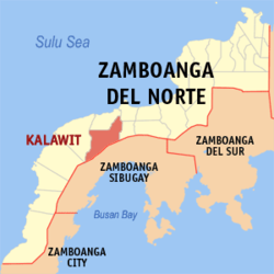 Map of Zamboanga del Norte with Kalawit highlighted | |
OpenStreetMap .mw-parser-output .locmap .od{position:absolute}.mw-parser-output .locmap .id{position:absolute;line-height:0}.mw-parser-output .locmap .l0{font-size:0;position:absolute}.mw-parser-output .locmap .pv{line-height:110%;position:absolute;text-align:center}.mw-parser-output .locmap .pl{line-height:110%;position:absolute;top:-0.75em;text-align:right}.mw-parser-output .locmap .pr{line-height:110%;position:absolute;top:-0.75em;text-align:left}.mw-parser-output .locmap .pv>div{display:inline;padding:1px}.mw-parser-output .locmap .pl>div{display:inline;padding:1px;float:right}.mw-parser-output .locmap .pr>div{display:inline;padding:1px;float:left}html.skin-theme-clientpref-night .mw-parser-output .od,html.skin-theme-clientpref-night .mw-parser-output .od .pv>div,html.skin-theme-clientpref-night .mw-parser-output .od .pl>div,html.skin-theme-clientpref-night .mw-parser-output .od .pr>div{background:#000;color:#fff}html.skin-theme-clientpref-night .mw-parser-output .locmap{filter:grayscale(0.6)}@media(prefers-color-scheme:dark){html.skin-theme-clientpref-os .mw-parser-output .locmap{filter:grayscale(0.6)}html.skin-theme-clientpref-os .mw-parser-output .od,html.skin-theme-clientpref-os .mw-parser-output .od .pv>div,html.skin-theme-clientpref-os .mw-parser-output .od .pl>div,html.skin-theme-clientpref-os .mw-parser-output .od .pr>div{background:#000;color:#fff}}  Kalawit Location within the Philippines | |
| Coordinates: 7°54′18″N 122°31′41″E / 7.905092°N 122.527947°E | |
| Country | Philippines |
| Region | Zamboanga Peninsula |
| Province | Zamboanga del Norte |
| District | 3rd district |
| Barangays | 14 (see Barangays) |
| Government | |
| • Type | Sangguniang Bayan |
| • Mayor | Salvador P. Antojado Jr. |
| • Vice Mayor | Merly C. Masugbo |
| • Representative | Adrian Michael A. Amatong |
| • Municipal Council | Members |
| • Electorate | 21,478 voters (2022) |
| Area | |
| • Total | 217.89 km2 (84.13 sq mi) |
| Elevation | 133 m (436 ft) |
| Highest elevation | 378 m (1,240 ft) |
| Lowest elevation | 93 m (305 ft) |
| Population (2020 census)[3] | |
| • Total | 23,812 |
| • Density | 110/km2 (280/sq mi) |
| • Households | 5,763 |
| Economy | |
| • Income class | 4th municipal income class |
| • Poverty incidence | 56.47 |
| • Revenue | ₱ 126.1 million (2020) |
| • Assets | ₱ 236.7 million (2020) |
| • Expenditure | ₱ 106.5 million (2020) |
| • Liabilities | ₱ 55.4 million (2020) |
| Service provider | |
| • Electricity | Zamboanga del Norte Electric Cooperative (ZANECO) |
| Time zone | UTC+8 (PST) |
| ZIP code | 7124 |
| PSGC | 097227000 |
| IDD : area code | +63 (0)65 |
| Native languages | Subanon Cebuano Chavacano Tagalog |
| Website | kalawit |
It was created by virtue of Republic Act No. 6851 on February 10, 1990.[5]
Geography edit
Barangays edit
Kalawit is politically subdivided into 14 barangays. Each barangay consists of puroks while some have sitios.
- Batayan
- Botong
- Concepcion
- Daniel Maing (Dominolog)
- Fatima (Lacsutan)
- Gatas
- Kalawit (Poblacion)
- Marcelo
- New Calamba
- Palalian
- Paraiso
- Pianon
- San Jose
- Tugop
Climate edit
| Climate data for Kalawit, Zamboanga del Norte | |||||||||||||
|---|---|---|---|---|---|---|---|---|---|---|---|---|---|
| Month | Jan | Feb | Mar | Apr | May | Jun | Jul | Aug | Sep | Oct | Nov | Dec | Year |
| Mean daily maximum °C (°F) | 29 (84) |
29 (84) |
30 (86) |
30 (86) |
29 (84) |
29 (84) |
28 (82) |
28 (82) |
29 (84) |
28 (82) |
29 (84) |
29 (84) |
29 (84) |
| Mean daily minimum °C (°F) | 22 (72) |
22 (72) |
23 (73) |
24 (75) |
24 (75) |
24 (75) |
24 (75) |
24 (75) |
24 (75) |
24 (75) |
24 (75) |
23 (73) |
24 (74) |
| Average precipitation mm (inches) | 96 (3.8) |
79 (3.1) |
117 (4.6) |
127 (5.0) |
239 (9.4) |
301 (11.9) |
286 (11.3) |
283 (11.1) |
255 (10.0) |
272 (10.7) |
188 (7.4) |
115 (4.5) |
2,358 (92.8) |
| Average rainy days | 17.3 | 16.0 | 19.7 | 21.6 | 29.0 | 29.0 | 29.7 | 29.1 | 28.5 | 28.9 | 25.3 | 20.0 | 294.1 |
| Source: Meteoblue[6] | |||||||||||||
Demographics edit
| Year | Pop. | ±% p.a. |
|---|---|---|
| 1990 | 12,340 | — |
| 1995 | 17,352 | +6.60% |
| 2000 | 21,372 | +4.57% |
| 2007 | 21,758 | +0.25% |
| 2010 | 22,157 | +0.66% |
| 2015 | 23,633 | +1.24% |
| 2020 | 23,812 | +0.15% |
| Source: Philippine Statistics Authority[7][8][9][10] | ||
Economy edit
References edit
- ^ Municipality of Kalawit | (DILG)
- ^ "2015 Census of Population, Report No. 3 – Population, Land Area, and Population Density" (PDF). Philippine Statistics Authority. Quezon City, Philippines. August 2016. ISSN 0117-1453. Archived (PDF) from the original on May 25, 2021. Retrieved July 16, 2021.
- ^ a b Census of Population (2020). "Region IX (Zamboanga Peninsula)". Total Population by Province, City, Municipality and Barangay. Philippine Statistics Authority. Retrieved 8 July 2021.
- ^ "PSA Releases the 2018 Municipal and City Level Poverty Estimates". Philippine Statistics Authority. 15 December 2021. Retrieved 22 January 2022.
- ^ "Republic Act No. 6851 - An Act Creating the Municipality of Kalawit in the Province of Zamboanga del Norte". Chan Robles Virtual Law Library. 10 February 1990. Retrieved 28 January 2016.
- ^ "Kalawit: Average Temperatures and Rainfall". Meteoblue. Retrieved 30 April 2020.
- ^ Census of Population (2015). "Region IX (Zamboanga Peninsula)". Total Population by Province, City, Municipality and Barangay. Philippine Statistics Authority. Retrieved 20 June 2016.
- ^ Census of Population and Housing (2010). "Region IX (Zamboanga Peninsula)" (PDF). Total Population by Province, City, Municipality and Barangay. National Statistics Office. Retrieved 29 June 2016.
- ^ Censuses of Population (1903–2007). "Region IX (Zamboanga Peninsula)". Table 1. Population Enumerated in Various Censuses by Province/Highly Urbanized City: 1903 to 2007. National Statistics Office.
{{cite encyclopedia}}: CS1 maint: numeric names: authors list (link) - ^ "Province of Zamboanga del Norte". Municipality Population Data. Local Water Utilities Administration Research Division. Retrieved 17 December 2016.
- ^ "Poverty incidence (PI):". Philippine Statistics Authority. Retrieved December 28, 2020.
- ^ "Estimation of Local Poverty in the Philippines" (PDF). Philippine Statistics Authority. 29 November 2005.
- ^ "2003 City and Municipal Level Poverty Estimates" (PDF). Philippine Statistics Authority. 23 March 2009.
- ^ "City and Municipal Level Poverty Estimates; 2006 and 2009" (PDF). Philippine Statistics Authority. 3 August 2012.
- ^ "2012 Municipal and City Level Poverty Estimates" (PDF). Philippine Statistics Authority. 31 May 2016.
- ^ "Municipal and City Level Small Area Poverty Estimates; 2009, 2012 and 2015". Philippine Statistics Authority. 10 July 2019.
- ^ "PSA Releases the 2018 Municipal and City Level Poverty Estimates". Philippine Statistics Authority. 15 December 2021. Retrieved 22 January 2022.
External links edit
- Kalawit Profile at PhilAtlas.com
- Philippine Standard Geographic Code
- Philippine Census Information