


Summary
Karnasuvarna or Karnasubarna was an ancient city, located in the present day Berhampore CD block in the Berhampore subdivision of Murshidabad district, West Bengal, India. It was the capital of Gauda Kingdom.[1]
Kānsonā | |
 Remains of Raktamrittika Vihara, c. 600 CE | |
 Shown within West Bengal | |
| Alternative name | Karnasubarna |
|---|---|
| Location | West Bengal, India |
| Coordinates | 24°01′49″N 88°11′27″E / 24.03028°N 88.19083°E |
| Type | Settlement |
| History | |
| Founded | 7th century AD |
| Site notes | |
| Excavation dates | 1929–30, 1962 |
| Archaeologists |
|
| Ownership | Archaeological Survey of India, University of Calcutta |
Geography edit


5miles
River
River
River
River
M: municipal town, CT: census town, R: rural/ urban centre, H: historical centres
Owing to space constraints in the small map, the actual locations in a larger map may vary slightly
Area overview edit
The area shown in the map alongside, covering Berhampore and Kandi subdivisions, is spread across both the natural physiographic regions of the district, Rarh and Bagri.[2][3] The headquarters of Murshidabad district, Berhampore, is in this area.[4] The ruins of Karnasubarna, the capital of Shashanka, the first important king of ancient Bengal who ruled in the 7th century, is located 9.6 kilometres (6.0 mi) south-west of Berhampore.[5][6][7] The entire area is overwhelmingly rural with over 80% of the population living in the rural areas.[8]
Note: The map alongside presents some of the notable locations in the subdivisions. All places marked in the map are linked in the larger full screen map.
History edit
Karnasuvarna (meaning 'made beautiful by Karna' or 'Gold of Ear', for 'karna' also means ear, and 'suvarna' means both beautiful and Gold, as evident from the Bangla name 'Kānsonā', where 'Kān' is ear and 'sonā' is Gold) was the capital of Gauda Kingdom during the reign of Raja Shashanka, the first important king of ancient Bengal who ruled in the 7th century. karnasuvarna was also known as KanaSona (কানাসুনা) by local people. According to folklore , it was the capital of Mahabharata king Karna .After Shashanka's death it was the Jayaskandhavara (camp of victory) of Bhaskaravarman, the king of Kamarupa probably for a short period. This is evident from his Nidhanpur copper-plate grant. In the mid-7th century, it was the capital of Jayanaga according to his Vappa Ghoshavata copper-plate grant. The ruins of Karnasuvarna have been located at Kansona in the present Murshidabad district in the Indian state of West Bengal.[9][10] It is 9.6 kilometres (6.0 mi) south-west of Berhampore, headquarters of Murshidabad district.[11]
In the List of Monuments of National Importance in West Bengal the following are shown as ASI listed monuments:[12]
- Mounds known as Devil’s Mound and Raja Karna’s Palace at Rangamati (Item No. 118).
- Nil Kuthi Mound at Mouza Chowk, Chandpara (Item No. 128).
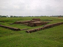
Excavations at Rajbaridanga edit
The famous Chinese traveler Xuanzang mentioned in his travelogues about Lo-to-mo-chi (Raktamrittika) Mahavihara, an important centre of learning of Vajrayana Buddhists near Karnasuvarna. It has been identified with Rajbaridanga. The archaeological site of Rajbaridanga is about 2.4 km from Karnasuvarna railway station in the bank of the Bhagirathi River. Local transport like cycle vans, e-rickshaws (Toto) are available. This site was first excavated by a team from the Department of Archaeology, University of Calcutta in 1962 under the direction of S.R. Das.[13] Amongst the findings, the most significant one was a monastic sealing bearing the legend Shri Rakta(m)rttika (Ma)havaiharik arya bhikshu (samgha)s(y)a (of the community of venerable monks residing in the Shri Raktamrittika Mahavihara). The other significant findings are terracotta figurines and ornamental stucco mouldings including human heads. Two other sites close by have been excavated at Rakshashidanga (in 1929–30 by K.N. Dixit of the Archaeological Survey of India) and Nil Kuthi.[14]
Rakshasi Danga and Rajbari Danga edit
Mounds locally known as Rakshasi Danga (Demoness’ Ground) and Rajbari Danga (Raja’s Palace Ground) have been excavated by the Archaeological Survey of India and the Archaeological Department of the University of Calcutta. The discovery of terracotta seals “bearing the legend Raktamrittika Mahavihara has identified the location of the monastery bearing the same name described in the accounts of Hiuen Tsang”, Chinese Buddhist monk and scholar who visited the place in the 7th century AD. The entire area contains “vestiges of ancient remains” from 2nd century AD to 15-16th century AD.[15]
Nilkuthi Mound edit
Nilkuthi Mound, adjacent to Rajbari Danga, is at a higher level, has yielded antiquities sporadically.[16]
Transport edit
Karna Subarna railway station (earlier known as Chiruti) is on the Barharwa-Azimganj-Katwa loop of Eastern Railway.
Bus services are available to district headquarters Baharampur from Karnasubarna.
Healthcare edit
Karnasuvarna Block Primary Health Centre, with 15 beds, is a government medical facility in Berhampore CD block.[17]
Gallery edit
-
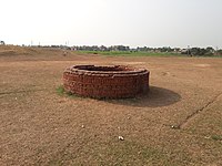 Well, Archaeological site of Karnasuvarna
 -
 Karnasuvarna, Rajbari Danga
 -
 Karnasuvarna ground
 -
 ASI Board at karnasuvarna


References edit
- ^ Majumdar, R. C. (1971). History of Ancient Bengal. Calcutta: G. Bhardwaj & Co. pp. 6–8. OCLC 961157849.
- ^ "District Census Handbook: Murshidabad, Series 20 Part XII A" (PDF). Physiography, Page 13. Directorate of Census Operations, West Bengal, 2011. Retrieved 24 July 2017.
- ^ "Murshidabad". Geography. Murshidabad district authorities. Retrieved 24 July 2017.
- ^ "Murshidabad". Murshidabad district authorities. Retrieved 12 September 2017.
- ^ Ray, Nihar Ranjan, Bangalir Itihas Adi Parba, (in Bengali), 1980 edition, pp. 160-161, Paschim Banga Niraksharata Durikaran Samiti
- ^ Sengupta, Nitish, History of the Bengali-speaking People, p.25, UBS Publishers’ Distributors Pvt. Ltd.
- ^ Majumdar, Dr. R.C., History of Ancient Bengal, first published 1971, reprint 2005, pp. 5-6, Tulshi Prakashani, Kolkata, ISBN 81-89118-01-3.
- ^ "District Census Handbook, Murshidabad, Series 20, Part XII B" (PDF). District Primary Census Abstract page 26. Directorate of Census Operations West Bengal. Retrieved 2 July 2021.
- ^ Ray, Nihar Ranjan, Bangalir Itihas Adi Parba, (in Bengali), 1980 edition, pp. 160–161, Paschim Banga Niraksharata Durikaran Samiti
- ^ Sengupta, Nitish, History of the Bengali-speaking People, p.25, UBS Publishers’ Distributors Pvt. Ltd.
- ^ Majumdar, Dr. R.C., History of Ancient Bengal, first published 1971, reprint 2005, pp. 5–6, Tulshi Prakashani, Kolkata, ISBN 81-89118-01-3.
- ^ "List of Ancient Monuments and Archaeological Sites and Remains of West Bengal - Archaeological Survey of India". Item no. 108. ASI. Retrieved 16 July 2021.
- ^ Ghosh, A., ed. (1965). "Indian Archaeology 1962–63 – A Review" (PDF). Archaeological Survey of India. p. 46. Retrieved 26 October 2009.
- ^ "Karnasuvarna". Rangan Datta, free-lance travel writer and photographer. Retrieved 23 September 2009.[permanent dead link]
- ^ "Mounds known as the Devil's Mound and Raja Karna's Palace". ASI, Kolkata Circle. Retrieved 3 June 2018.
- ^ "Nilkuthi Mound Mouza Chawk, Chandpara". ASI, Kolkata Circle. Retrieved 3 June 2018.
- ^ "Health & Family Welfare Department". Health Statistics. Government of West Bengal. Retrieved 19 September 2017.
External links edit
 Media related to Karnasuvarna at Wikimedia Commons
 Murshidabad travel guide from Wikivoyage