


Summary
Khan Na Yao (Thai: คันนายาว, pronounced [kʰān nāː jāːw]) is one of the 50 districts (khet) of Bangkok, Thailand. It is bounded by other Bangkok districts (from north clockwise): Bang Khen, Khlong Sam Wa, Min Buri, Saphan Sung, and Bueng Kum.
Khan Na Yao
คันนายาว | |
|---|---|
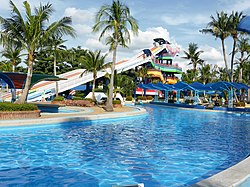 Slider and swimming pool of Siam Park City | |
 Khet location in Bangkok | |
| Country | Thailand |
| Province | Bangkok |
| Seat | Khan Na Yao |
| Khwaeng | 2 |
| Khet established | 21 November 1997 |
| Area | |
| • Total | 25.980 km2 (10.031 sq mi) |
| Population (2017) | |
| • Total | 96,751[2] |
| • Density | 3,724.05/km2 (9,645.2/sq mi) |
| Time zone | UTC+7 (ICT) |
| Postal code | 10230 |
| Geocode | 1043 |
History edit
Khan Na Yao was separated from Bueng Kum on 14 October 1997 announcement, effective 21 November 1997, together with Saphan Sung.[3]
Its name means "long paddy-field ridge", describing the geography of the district in the past; Khan Na Yao was an agricultural district. Until now, the rice fields and its ridges are long gone; they are part of the present-day Seri Thai road.
Administration edit
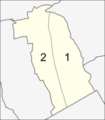
The district is divided into two sub-districts (khwaeng).
| No. | Name | Thai | Area (km2) |
Map |
|---|---|---|---|---|
1. |
Khan Na Yao | คันนายาว | 12.917 |
|
2. |
Ram Inthra | รามอินทรา | 13.063
| |
| Total | 25.980
| |||
Places edit
- Wat Rat Sattha Tham
- Navatanee Golf Course
- Siam Park City
- Fashion Island
- Bangchan Industrial Estate
District council edit
The District Council for Khan Na Yao has seven members, who each serve four-year terms. Elections were last held on 30 April 2006. The Thai Rak Thai Party won seven seats.
References edit
- ^ Administrative Strategy Division, Strategy and Evaluation Department, Bangkok Metropolitan Administration (2021). สถิติกรุงเทพมหานครประจำปี 2563 [Bangkok Statistics 2020] (PDF) (in Thai). Retrieved 27 November 2021.
{{cite web}}: CS1 maint: multiple names: authors list (link) - ^ "Population and House Report for Year 2017 (see page 2 for data of this district)". Department of Provincial Administration, Ministry of Internal Affairs. Retrieved 2018-04-01. (Search page)
- ^ ประกาศกระทรวงมหาดไทย เรื่อง เปลี่ยนแปลงพื้นที่เขตบางเขน เขตลาดพร้าว เขตบึงกุ่ม เขตประเวศ และตั้งเขตสายไหม เขตคันนายาว เขตสะพานสูง (PDF). Royal Gazette (in Thai). 114 (พิเศษ 108 ง): 6. 1997-11-18. Archived from the original (PDF) on November 7, 2011.
External links edit
- BMA website with the tourist landmarks of Khan Na Yao
- Khan Na Yao district office (Thai only)