
KNOWPIA
WELCOME TO KNOWPIA

Khirbat Zawiya 
Summary
Al-Zawiya (Arabic: الزاوية), was a Palestinian Arab village in the District of Baysan. It was depopulated by the Israel Defense Forces during the 1948 Arab-Israeli War on May 15–18, 1948 under Operation Gideon. It was located 11.5 km northeast of Baysan. The Crusader Castle Belvoir is located close to the village.
Al-Zawiya
الزاوية | |
|---|---|
| Etymology: The corner | |
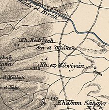 1870s map 1870s map 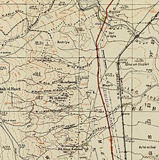 1940s map 1940s map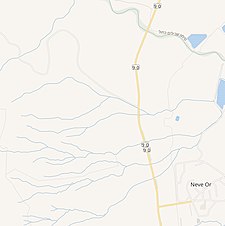 modern map modern map  1940s with modern overlay map 1940s with modern overlay mapA series of historical maps of the area around Khirbat Zawiya (click the buttons) | |
 Al-Zawiya Location within Mandatory Palestine | |
| Coordinates: 32°35′50″N 35°32′26″E / 32.59722°N 35.54056°E | |
| Palestine grid | 201/222 |
| Geopolitical entity | Mandatory Palestine |
| Subdistrict | Baysan |
| Date of depopulation | May 15th-18th, 1948 |
History edit
It was classified as a hamlet in the Palestine Index Gazetteer.[1]
References edit
- ^ Khalidi, 1992, p. 67
Bibliography edit
- Khalidi, W. (1992). All That Remains: The Palestinian Villages Occupied and Depopulated by Israel in 1948. Washington D.C.: Institute for Palestine Studies. ISBN 0-88728-224-5.
- Morris, B. (2004). The Birth of the Palestinian Refugee Problem Revisited. Cambridge University Press. ISBN 978-0-521-00967-6.
External links edit
- Welcome To al-Zawiya, Khirbat
- Khirbat al-Zawiya, Zochrot
- Survey of Western Palestine, map 9: IAA, Wikimedia commons