
KNOWPIA
WELCOME TO KNOWPIA

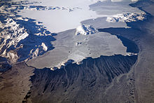
Kiglapait Mountains 
Summary
The Kiglapait Mountains lie north of Nain, in northern Labrador, south of the Torngat and Kaumajet Mountains. Not as high as those ranges, they still boast very rugged terrain and many peaks with high prominence values. The name means "dog-tooth."

| Rank | Name | m | ft |
|---|---|---|---|
| 1 | Man O'War Peak | 1050 | 3445 |
| 2 | Peak 3400 (14E/2) | 1036+ | 3400+ |
| 3 | Peak 3300 (14E/1) | 1006+ | 3300+ |
| 4 | Peak 3300 (14E/2) | 1006+ | 3300+ |
| 5 | Peak 3200 (14E/1) | 975+ | 3200 |
| 6 | Peak 3100 (14E/1) | 945+ | 3100+ |
| 7 | Peak 3000#1 (14D/16) | 914+ | 3000+ |
| 8 | Aupalukitak Mountain | 914+ | 3000+ |
| 9 | Mount Thoresby | 914+ | 3000+ |
| 10 | Peak 3000#2 (14D/16) | 914+ | 3000+ |
External links edit
- "Kiglapait Mountains 2500-foot Peaks". Peakbagger.com.
- Photo gallery, Aerial photos of Kiglapait Mountains by Doc Searls
57°06′00″N 61°34′57″W / 57.10000°N 61.58250°W