


Summary
Kitcharao, officially the Municipality of Kitcharao (Cebuano: Lungsod sa Kitcharao; Tagalog: Bayan ng Kitcharao), is a 4th class municipality in the province of Agusan del Norte, Philippines. According to the 2020 census, it has a population of 21,278 people.[3]
Kitcharao | |
|---|---|
| Municipality of Kitcharao | |
 Flag  Seal | |
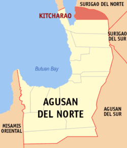 Map of Agusan del Norte with Kitcharao highlighted | |
OpenStreetMap .mw-parser-output .locmap .od{position:absolute}.mw-parser-output .locmap .id{position:absolute;line-height:0}.mw-parser-output .locmap .l0{font-size:0;position:absolute}.mw-parser-output .locmap .pv{line-height:110%;position:absolute;text-align:center}.mw-parser-output .locmap .pl{line-height:110%;position:absolute;top:-0.75em;text-align:right}.mw-parser-output .locmap .pr{line-height:110%;position:absolute;top:-0.75em;text-align:left}.mw-parser-output .locmap .pv>div{display:inline;padding:1px}.mw-parser-output .locmap .pl>div{display:inline;padding:1px;float:right}.mw-parser-output .locmap .pr>div{display:inline;padding:1px;float:left}html.skin-theme-clientpref-night .mw-parser-output .od,html.skin-theme-clientpref-night .mw-parser-output .od .pv>div,html.skin-theme-clientpref-night .mw-parser-output .od .pl>div,html.skin-theme-clientpref-night .mw-parser-output .od .pr>div{background:#000;color:#fff}html.skin-theme-clientpref-night .mw-parser-output .locmap{filter:grayscale(0.6)}@media(prefers-color-scheme:dark){html.skin-theme-clientpref-os .mw-parser-output .locmap{filter:grayscale(0.6)}html.skin-theme-clientpref-os .mw-parser-output .od,html.skin-theme-clientpref-os .mw-parser-output .od .pv>div,html.skin-theme-clientpref-os .mw-parser-output .od .pl>div,html.skin-theme-clientpref-os .mw-parser-output .od .pr>div{background:#000;color:#fff}}  Kitcharao Location within the Philippines | |
| Coordinates: 9°28′N 125°35′E / 9.46°N 125.58°E | |
| Country | Philippines |
| Region | Caraga |
| Province | Agusan del Norte |
| District | 2nd district |
| Founded | August 29, 1963 |
| Barangays | 11 (see Barangays) |
| Government | |
| • Type | Sangguniang Bayan |
| • Mayor | Aristotle E. Montante |
| • Vice Mayor | Leo D. Galua |
| • Representative | Ma. Angelica Amante-Matba |
| • Municipal Council | Members |
| • Electorate | 14,542 voters (2022) |
| Area | |
| • Total | 171.92 km2 (66.38 sq mi) |
| Elevation | 168 m (551 ft) |
| Highest elevation | 772 m (2,533 ft) |
| Lowest elevation | 38 m (125 ft) |
| Population (2020 census)[3] | |
| • Total | 21,278 |
| • Density | 120/km2 (320/sq mi) |
| • Households | 4,969 |
| Economy | |
| • Income class | 4th municipal income class |
| • Poverty incidence | 23.89 |
| • Revenue | ₱ 115.1 million (2020) |
| • Assets | ₱ 520.2 million (2020) |
| • Expenditure | ₱ 102.4 million (2020) |
| • Liabilities | ₱ 91.8 million (2020) |
| Service provider | |
| • Electricity | Agusan del Norte Electric Cooperative (ANECO) |
| Time zone | UTC+8 (PST) |
| ZIP code | 8609 |
| PSGC | 160206000 |
| IDD : area code | +63 (0)85 |
| Native languages | Agusan Butuanon Cebuano Higaonon Mamanwa Tagalog |
| Website | www |
History edit
Kitcharao was created on June 22, 1963, under Republic Act No. 3842,[5] sponsored by Congressman Guillermo R. Sánchez. It was once a barrio of Jabonga. Through the initiative of the then Vice Mayor Francisco M. Tuozo of Jabonga, a resolution was sponsored petitioning Congress for the creation of the Municipality of Kitcharao.
The inhabitants of the municipality came from various regions in Luzon and the Visayas, hence the presence of Ilocanos, Tagalogs, Leyteños, Hiligaynons, Warays, Cebuanos, Boholanos, and indigenous people known as the Mamanwas.
On August 29, 1963, the first Municipal Officials were inducted to the office by then Governor Democrito O. Plaza. Félix Q. Basadre, Sr. was the appointed Mayor, Marceliano Morada as Vice Mayor and the councilors Mariano M. Napalan, Sr., Gaudencio Pojas, Pencionico Bermúdez, Juan Tidalgo, Agustín Patagan and Uldarico Atuel.
The same set of Municipal Officials was elected in the ensuing regular election in November 1963.[6]
In 2005, Barangays Crossing and Songkoy were created.[7]
Geography edit
According to the Philippine Statistics Authority, the municipality has a land area of 171.92 square kilometres (66.38 sq mi) [8] constituting 6.30% of the 2,730.24-square-kilometre- (1,054.15 sq mi) total area of Agusan del Norte.
Climate edit
| Climate data for Kitcharao, Agusan del Norte | |||||||||||||
|---|---|---|---|---|---|---|---|---|---|---|---|---|---|
| Month | Jan | Feb | Mar | Apr | May | Jun | Jul | Aug | Sep | Oct | Nov | Dec | Year |
| Mean daily maximum °C (°F) | 27 (81) |
27 (81) |
28 (82) |
29 (84) |
30 (86) |
29 (84) |
29 (84) |
29 (84) |
29 (84) |
29 (84) |
28 (82) |
28 (82) |
29 (83) |
| Mean daily minimum °C (°F) | 23 (73) |
23 (73) |
23 (73) |
23 (73) |
24 (75) |
25 (77) |
24 (75) |
24 (75) |
24 (75) |
24 (75) |
24 (75) |
23 (73) |
24 (74) |
| Average precipitation mm (inches) | 210 (8.3) |
161 (6.3) |
123 (4.8) |
85 (3.3) |
148 (5.8) |
186 (7.3) |
164 (6.5) |
157 (6.2) |
141 (5.6) |
190 (7.5) |
223 (8.8) |
200 (7.9) |
1,988 (78.3) |
| Average rainy days | 21.0 | 16.8 | 18.5 | 18.2 | 24.9 | 27.7 | 28.4 | 27.0 | 26.1 | 27.6 | 24.6 | 22.0 | 282.8 |
| Source: Meteoblue[9] | |||||||||||||
Barangays edit
Kitcharao is politically subdivided into 11 barangays.[10] Each barangay consists of puroks while some have sitios.
| PSGC | Barangay | Population | ±% p.a. | |||
|---|---|---|---|---|---|---|
| 2020[3] | 2010[11] | |||||
| 160206001 | Bangayan | 5.9% | 1,254 | 1,134 | 1.01% | |
| 160206002 | Canaway | 5.9% | 1,259 | 1,183 | 0.62% | |
| 160206010 | Crossing | 15.4% | 3,274 | 3,103 | 0.54% | |
| 160206003 | Hinimbangan | 1.4% | 299 | 458 | −4.17% | |
| 160206004 | Jaliobong | 7.3% | 1,551 | 1,755 | −1.23% | |
| 160206005 | Mahayahay | 12.4% | 2,632 | 2,290 | 1.40% | |
| 160206006 | Poblacion | 10.3% | 2,198 | 1,882 | 1.56% | |
| 160206007 | San Isidro | 5.8% | 1,227 | 1,067 | 1.41% | |
| 160206008 | San Roque | 9.2% | 1,947 | 1,785 | 0.87% | |
| 160206009 | Sangay | 4.9% | 1,038 | 903 | 1.40% | |
| 160206011 | Songkoy | 9.3% | 1,980 | 1,817 | 0.86% | |
| Total | 21,278 | 17,377 | 2.05% | |||
Demographics edit
| Year | Pop. | ±% p.a. |
|---|---|---|
| 1970 | 9,960 | — |
| 1975 | 10,524 | +1.11% |
| 1980 | 11,785 | +2.29% |
| 1990 | 13,598 | +1.44% |
| 1995 | 14,679 | +1.44% |
| 2000 | 15,950 | +1.80% |
| 2007 | 21,426 | +4.15% |
| 2010 | 17,377 | −7.34% |
| 2015 | 18,659 | +1.36% |
| 2020 | 21,278 | +2.62% |
| Source: Philippine Statistics Authority[12][11][13][14] | ||
In the 2020 census, Kitcharao had a population of 21,278.[3] The population density was 120 inhabitants per square kilometre (310/sq mi).
Economy edit
Transportation edit
The Kitcharao Land Transport Terminal serves multicabs, buses, vans and jeepneys bound for Butuan/Surigao.
References edit
- ^ Municipality of Kitcharao | (DILG)
- ^ "2015 Census of Population, Report No. 3 – Population, Land Area, and Population Density" (PDF). Philippine Statistics Authority. Quezon City, Philippines. August 2016. ISSN 0117-1453. Archived (PDF) from the original on May 25, 2021. Retrieved July 16, 2021.
- ^ a b c d Census of Population (2020). "Caraga". Total Population by Province, City, Municipality and Barangay. Philippine Statistics Authority. Retrieved July 8, 2021.
- ^ "PSA Releases the 2018 Municipal and City Level Poverty Estimates". Philippine Statistics Authority. December 15, 2021. Retrieved January 22, 2022.
- ^ "Republic Act No. 3842 - An Act Creating the Municipality of Kitcharao in the Province of Agusan". Chan Robles Virtual Law Library. June 22, 1963. Archived from the original on May 19, 2014. Retrieved October 16, 2016.
- ^ Municipality of Kitcharao (September 13, 2010). "History of Kitcharao". Retrieved September 13, 2010.
- ^ National Statistical Coordination Board (February 27, 2006). "2006 Factsheet". Archived from the original on May 28, 2006. Retrieved June 24, 2006.
- ^ "Province: Agusan del Norte". PSGC Interactive. Quezon City, Philippines: Philippine Statistics Authority. Retrieved November 12, 2016.
- ^ "Kitcharao: Average Temperatures and Rainfall". Meteoblue. Retrieved February 2, 2020.
- ^ "Municipal: Kitcharao". PSGC Interactive. Quezon City, Philippines: Philippine Statistics Authority. Retrieved January 8, 2016.
- ^ a b Census of Population and Housing (2010). "Caraga" (PDF). Total Population by Province, City, Municipality and Barangay. National Statistics Office. Retrieved June 29, 2016.
- ^ Census of Population (2015). "Caraga". Total Population by Province, City, Municipality and Barangay. Philippine Statistics Authority. Retrieved June 20, 2016.
- ^ Censuses of Population (1903–2007). "Caraga". Table 1. Population Enumerated in Various Censuses by Province/Highly Urbanized City: 1903 to 2007. National Statistics Office.
{{cite encyclopedia}}: CS1 maint: numeric names: authors list (link) - ^ "Province of Agusan del Norte". Municipality Population Data. Local Water Utilities Administration Research Division. Retrieved December 17, 2016.
- ^ "Poverty incidence (PI):". Philippine Statistics Authority. Retrieved December 28, 2020.
- ^ "Estimation of Local Poverty in the Philippines" (PDF). Philippine Statistics Authority. November 29, 2005.
- ^ "2003 City and Municipal Level Poverty Estimates" (PDF). Philippine Statistics Authority. March 23, 2009.
- ^ "City and Municipal Level Poverty Estimates; 2006 and 2009" (PDF). Philippine Statistics Authority. August 3, 2012.
- ^ "2012 Municipal and City Level Poverty Estimates" (PDF). Philippine Statistics Authority. May 31, 2016.
- ^ "Municipal and City Level Small Area Poverty Estimates; 2009, 2012 and 2015". Philippine Statistics Authority. July 10, 2019.
- ^ "PSA Releases the 2018 Municipal and City Level Poverty Estimates". Philippine Statistics Authority. December 15, 2021. Retrieved January 22, 2022.
External links edit
- Philippine Standard Geographic Code
- Community Website of Kitcharao Archived January 27, 2019, at the Wayback Machine