


Summary
Lime is an unincorporated community and ghost town in the northwest United States, located in Baker County, Oregon.[1] Five miles (8 km) north of Huntington on Interstate 84 (& U.S. Route 30), it is near the confluence of Marble Creek and the Burnt River on the Union Pacific Railroad. The historic Oregon Trail passes through Lime.[2]
Lime, Oregon | |
|---|---|
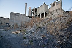 Abandoned cement plant at Lime, circa 2012 | |
 Lime Location in the United States  Lime Location in Oregon | |
| Coordinates: 44°24′24″N 117°18′41″W / 44.40667°N 117.31139°W | |
| Country | United States |
| State | Oregon |
| County | Baker |
| Elevation | 2,234 ft (681 m) |
| Time zone | UTC-8 (Pacific (PST)) |
| • Summer (DST) | UTC-7 (PDT) |
| Area code(s) | 458 and 541 |
| GNIS feature ID | 1167713[1] |
History edit
The Lime post office was established 125 years ago in 1899.[3] The deposits of limestone in the area were manufactured into lime that supplied a large area of Eastern Oregon and western Idaho.[3][4] The Acme Cement Plaster Company built a plant at Lime in 1916 to produce plaster.[3] The Sun Portland Cement Company bought the plant in 1921 and built another facility for producing Portland cement.[3] In 1926, the company merged with Oregon Portland Cement Company from Portland; by the 1960s, the Lime facility produced 1,200,000 barrels a year.[3] In 1940, the community at its peak had a population of 18.[5] The town began to decline when the post office closed in 1964.
As the nearby limestone deposits were depleted, limestone was brought from the Nelson area near Durkee.[3] A new plant was built at Nelson in 1979 and the facility at Lime was closed in 1980.[3] Oregon Portland Cement Company merged with the Ash Grove Cement Company in 1983.[3][6]
In 1999, Baker County took possession of the site of the closed factory for back taxes. In 2018, the plant was scheduled for demolition; crews arrived that April to begin the work.[7]
See also edit
References edit
- ^ a b "Lime". Geographic Names Information System. United States Geological Survey. November 28, 1980. Retrieved November 15, 2016.
- ^ Friedman, Ralph (2002) [1993]. The Other Side of Oregon (2nd ed.). Caldwell, Idaho: The Caxton Printers, Ltd. p. 46. ISBN 0-87004-352-8.
- ^ a b c d e f g h McArthur, Lewis A.; Lewis L. McArthur (2003) [1928]. Oregon Geographic Names (7th ed.). Portland, Oregon: Oregon Historical Society Press. p. 578. ISBN 0-87595-277-1.
- ^ Bailey, Barbara Ruth (1982). Main Street: Northeastern Oregon. Oregon Historical Society. p. 32. ISBN 0-87595-073-6.
- ^ Writers' Program of the Work Projects Administration in the State of Oregon (1940). Oregon: End of the Trail. American Guide Series. Portland, Oregon: Binfords & Mort. p. 251. OCLC 4874569.
- ^ Merriman, Ed (November 27, 2009). "Durkee Doldrums: Locals Fear Ash Grove Layoffs Will Doom Businesses". Baker City Herald. Retrieved January 4, 2010.
- ^ Collins, Chris. "Tumbling Down Contractor expects to finish demolition project by the first of June". Baker City Herald. Retrieved August 1, 2018.
External links edit
- Images of abandoned cement plant at Lime from Flickr
- Cockle, Richard (April 22, 2012). "Grand Idea to Turn Eastern Oregon Eyesore into Utopia Sparks Skepticism But Also Sliver of Hope". The Oregonian.