


Summary
Greece has many islands,[Note 1] with estimates ranging from somewhere around 1,200[1] to 6,000,[2] depending on the minimum size to take into account. The number of inhabited islands is variously cited as between 166[3] and 227.[2]
The largest Greek island by both area and population is Crete, located at the southern edge of the Aegean Sea. The second largest island in area is Euboea or Evvia, which is separated from the mainland by the 60m-wide Euripus Strait, and is administered as part of the Central Greece region. After the third and fourth largest Greek islands, Lesbos and Rhodes, the rest of the islands are two-thirds of the area of Rhodes, or smaller.
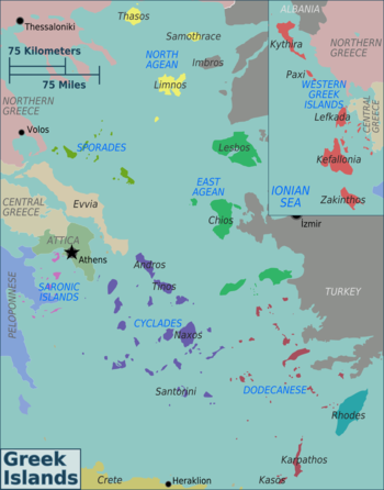
The Greek islands are traditionally grouped into the following clusters: the Argo-Saronic Islands in the Saronic Gulf near Athens; the Cyclades, a large but dense collection occupying the central part of the Aegean Sea; the North Aegean islands, a loose grouping off the west coast of Turkey; the Dodecanese, another loose collection in the southeast between Crete and Turkey; the Sporades, a small tight group off the coast of Euboea; and the Ionian Islands, chiefly located to the west of the mainland in the Ionian Sea. Crete with its surrounding islets and Euboea are traditionally excluded from this grouping.
This article excludes the Peloponnese, which has technically been an island since the construction of the Corinth Canal in 1893, but is rarely considered to be an island due to its artificial origins.
Islands of Greece by size edit


The following are the 40 largest Greek islands listed by surface area.
| Island | Greek name | Area (miles2) |
Area (km2) |
Cluster | |
|---|---|---|---|---|---|
| 1 | Crete | Κρήτη | 3,219 | 8,336 | Cretan |
| 2 | Evia | Εύβοια | 1,417 | 3,670 | Euboean |
| 3 | Lesbos | Λέσβος | 630 | 1,633 | North Aegean Islands |
| 4 | Rhodes | Ρόδος | 541 | 1,401 | Dodecanese |
| 5 | Chíos | Χίος | 325 | 842.3 | North Aegean Islands |
| 6 | Kefalonia | Κεφαλονιά | 302 | 781 | Ionian Islands |
| 7 | Corfu | Κέρκυρα | 229 | 592.9 | Ionian Islands |
| 8 | Lemnos | Λήμνος | 184 | 477.6 | North Aegean Islands |
| 9 | Samos | Σάμος | 184 | 477.4 | North Aegean Islands |
| 10 | Naxos | Νάξος | 166 | 429.8 | Cyclades |
| 11 | Zakynthos | Ζάκυνθος | 157 | 406 | Ionian Islands |
| 12 | Thassos | Θάσος | 147 | 380.1 | North Aegean Islands |
| 13 | Andros | Άνδρος | 147 | 380.0 | Cyclades |
| 14 | Lefkada | Λευκάδα | 117 | 303 | Ionian Islands |
| 15 | Karpathos | Κάρπαθος | 116 | 300 | Dodecanese |
| 16 | Kos | Κως | 112 | 290.3 | Dodecanese |
| 17 | Kythira | Κύθηρα | 108 | 279.6 | Ionian Islands |
| 18 | Icaria | Ικαρία | 99 | 255 | North Aegean Islands |
| 19 | Skyros | Σκύρος | 81 | 209 | Sporades |
| 20 | Paros | Πάρος | 75 | 195 | Cyclades |
| 21 | Tinos | Τήνος | 75 | 194 | Cyclades |
| 22 | Samothrace | Σαμοθράκη | 69 | 178 | North Aegean Islands |
| 23 | Milos | Μήλος | 58 | 151 | Cyclades |
| 24 | Kea | Κέα | 51 | 132 | Cyclades |
| 25 | Amorgos | Αμοργός | 47 | 121 | Cyclades |
| 26 | Kalymnos | Κάλυμνος | 42.5 | 110 | Dodecanese |
| 27 | Ios | Ίος | 41.7 | 108 | Cyclades |
| 28 | Kythnos | Κύθνος | 38.4 | 99.4 | Cyclades |
| 29 | Astypalaia | Αστυπάλαια | 37.2 | 96.4 | Dodecanese |
| 30 | Ithaca | Ιθάκη | 37.1 | 96.2 | Ionian Islands |
| 31 | Salamis | Σαλαμίνα | 37.1 | 96.2 | Argo-Saronic |
| 32 | Skopelos | Σκόπελος | 37.1 | 96.2 | Sporades |
| 33 | Mykonos | Μύκονος | 33.0 | 85.5 | Cyclades |
| 34 | Syros | Σύρος | 32.0 | 83.6 | Cyclades |
| 35 | Aegina | Αίγινα | 31.9 | 82.6 | Argo-Saronic |
| 36 | Santorini | Σαντορίνη | 29.4 | 76.2 | Cyclades |
| 37 | Serifos | Σέριφος | 29.0 | 75.2 | Cyclades |
| 38 | Sifnos | Σίφνος | 28.6 | 73.9 | Cyclades |
| 39 | Kasos | Κάσος | 26.8 | 69.5 | Dodecanese |
| 40 | Alonnisos | Αλόννησος | 24.7 | 64.1 | Sporades |
Islands of Greece by population edit
| Island | Population |
|---|---|
| Crete | 636,504 |
| Evia | 191,206 |
| Rhodes | 125,113 |
| Lesbos | 83,755 |
| Corfu | 102,071 |
| Chios | 50,361 |
| Zakynthos | 41,180 |
| Salamis | 37,220 |
| Kefalonia | 36,064 |
| Kos | 37,089 |
| Samos | 32,642 |
| Lefkada | 21,900 |
| Syros | 21,507 |
| Naxos | 20,578 |
| Lemnos | 16,411 |
| Kalymnos | 17,752 |
| Santorini | 15,480 |
| Thasos | 13,104 |
| Paros | 14,520 |
| Aegina | 12,911 |
| Mykonos | 10,704 |
| Tinos | 8,934 |
| Andros | 8,826 |
| Icaria | 8,843 |
| Leros | 7,992 |
| Skiathos | 5,802 |
| Aitoliko | 4,935 |
| Karpathos | 6,567 |
| Milos | 5,302 |
| Skopelos | 4,518 |
| Kythira | 3,644 |
| Ithaca | 2,862 |
| Patmos | 3,283 |
| Skyros | 3,052 |
| Samothrace | 2,596 |
| Sifnos | 2,777 |
| Alonnisos | 3,138 |
| Symi | 2,603 |
| Kea | 2,335 |
| Paxos | 2,466 |
| Poros | 3,261 |
| Spetses | 3,748 |
Islands of the Aegean Sea edit
Argo-Saronic Islands edit

This list includes Argo-Saronic islands, which are located in the Saronic Gulf. The largest Argo-Saronic island is Salamis. The main islands are in bold. Uninhabited islands are indicated, including those that may have been inhabited in the past:
- Aegina (87.41 km2 (33.75 sq mi)), 37°43′48″N 23°29′24″E / 37.73000°N 23.49000°E
- Agios Georgios (uninhabited), 37°28′26″N 23°55′34″E / 37.47389°N 23.92611°E
- Agios Georgios Salaminos (St. George's Island, uninhabited), 37°57′47″N 23°32′22″E / 37.962926260802554°N 23.539466052244535°E[4]
- Agios Ioannis Diaporion (uninhabited)
- Agios Thomas Diaporion (uninhabited), 37°48′37.30″N 23°14′46.40″E / 37.8103611°N 23.2462222°E
- Agistri (13.37 km2 (5.16 sq mi)), 37°42′N 23°20′E / 37.700°N 23.333°E
- Alexandros Hydras, 37°17′03″N 23°22′08″E / 37.28429°N 23.36875°E
- Atalanti Island, 37°56′06″N 23°34′21″E / 37.93500°N 23.57250°E
- Dia (uninhabited)
- Dokos (13.537 km2 (5.227 sq mi)), 37°19′59.21″N 23°19′16.82″E / 37.3331139°N 23.3213389°E
- Falkonera (uninhabited), 36°50′31″N 23°53′06″E / 36.842°N 23.885°E
- Fleves (uninhabited), 37°46′10″N 23°45′44″E / 37.7694°N 23.76222°E
- Hydra (64.443 km2 (24.882 sq mi)), 37°20′06″N 23°28′21″E / 37.33500°N 23.47250°E
- Katramoniso (Nisís Idhroúsa, uninhabited), 37°50′08″N 23°44′44″E / 37.83555°N 23.74566°E[5]
- Kyra Aiginis (Nisída Kyrá) (uninhabited), 37°42′12″N 23°15′44″E / 37.70329°N 23.2621°E
- Laousses Islets (Nísoi Laoúses, uninhabited), 37°49′06″N 23°27′27″E / 37.81828°N 23.45756°E
- Leros Salaminos (uninhabited), 37°59′33″N 23°32′17″E / 37.992576702438996°N 23.538185826815862°E
- Modi Porou (uninhabited), 37°30′37″N 23°31′52″E / 37.51031°N 23.53117°E
- Moni Aiginas (uninhabited), 37°41′31″N 23°26′06″E / 37.69197°N 23.43504°E
- Patroklos (uninhabited), 37°39′02.50″N 23°57′01.50″E / 37.6506944°N 23.9504167°E
- Pera Island (Arta), 37°53′46″N 23°29′54″E / 37.89623°N 23.49831°E
- Platia (uninhabited), 37°48′41″N 23°22′59″E / 37.81142°N 23.38318°E
- Platia Aeginis (uninhabited), 37°34′34″N 23°30′26″E / 37.57622°N 23.50711°E
- Poros (49.582 km2 (19.144 sq mi)), 37°31′N 23°29′E / 37.517°N 23.483°E
- Psili (uninhabited)
- Psyttaleia (uninhabited), 37°56′24″N 23°35′17″E / 37.94°N 23.588°E
- Revythousa (uninhabited), 37°57′41″N 23°24′05″E / 37.96139°N 23.40139°E
- Romvi (Nisida Romvi) (uninhabited), 37°30′34″N 22°51′54″E / 37.50955°N 22.865°E
- Salamis (96.16 km2 (37.13 sq mi)), 37°56′N 23°30′E / 37.933°N 23.500°E
- Spetses (27.121 km2 (10.471 sq mi)), 37°15′N 23°08′E / 37.250°N 23.133°E
- Spetsopoula (uninhabited), 37°13′N 23°10′E / 37.22°N 23.17°E
- Stavronisi Hydras (uninhabited), 37°15′13″N 23°26′46″E / 37.25367°N 23.44622°E
- Trikeri Hydras (uninhabited), 37°16′01″N 23°16′55″E / 37.26702°N 23.28198°E
- Velopoula (Nisída Velopoúla) (uninhabited), 36°54′58″N 23°27′41″E / 36.916°N 23.46148°E
- Ypsili Diaporion (uninhabited)
- Ypsili Argolidos (uninhabited)
Cretan island edit
The two lists below show the islands, islets, and rocks that surround the island of Crete that are in the Aegean Sea or Libyan Sea.
Cretan islands of the Aegean Sea edit


- Afendis Christos, 35°17′43″N 25°27′39″E / 35.2954°N 25.4609°E
- Agia Varvara, 35°17′51″N 25°28′04″E / 35.2975°N 25.4678°E
- Agioi Apostoloi, 35°31′09″N 23°59′59″E / 35.51917°N 23.99972°E
- Agioi Pandes, 35°11′53″N 25°43′51″E / 35.19793°N 25.73079°E[6]
- Agioi Theodoroi, 35°32′13″N 23°55′52″E / 35.537°N 23.931°E
- Agios Nikolaos, 35°21′57″N 24°15′49″E / 35.3658°N 24.2637°E
- Agriomandra, 35°07′53″N 25°49′53″E / 35.13139°N 25.83139°E
- Anavatis, 35°01′46″N 26°13′37″E / 35.02931°N 26.22698°E
- Arnaouti, 35°36′12″N 23°34′42″E / 35.60333°N 23.57833°E
- Avgo (uninhabited islet), 35°36′11″N 25°34′37″E / 35.603°N 25.577°E
- Crete, 35°12.6′N 24°54.6′E / 35.2100°N 24.9100°E
- Daskaleia (uninhabited islet), 35°18′01″N 26°18′37″E / 35.30028°N 26.31028°E
- Dia (Zeus, uninhabited), 35°26′53″N 25°13′12″E / 35.448°N 25.220°E
- Diapori, 35°25′18″N 24°52′32″E / 35.4217°N 24.8756°E
- Dionysades (group of islands), 35°21′N 26°11′E / 35.35°N 26.18°E
- Gianysada, 35°19′41″N 26°10′26″E / 35.328°N 26.174°E
- Dragonada, 35°20′42″N 26°10′41″E / 35.345°N 26.178°E
- Paximada, 35°22′37″N 26°10′26″E / 35.377°N 26.174°E
- Paximadaki, 35°21′29″N 26°10′41″E / 35.358°N 26.178°E
- Elasa, 35°16′23″N 26°20′24″E / 35.273°N 26.340°E
- Ftena Trachylia, 35°18′56″N 26°17′14″E / 35.31556°N 26.28722°E
- Glaronisi, 35°27′48″N 25°11′27″E / 35.4634°N 25.1908°E
- Gramvoussa, 35°36′40″N 23°34′45″E / 35.61111°N 23.57917°E
- Agria Gramvousa, 35°38′32″N 23°35′12″E / 35.64227°N 23.58667°E
- Imeri Gramvousa, 35°36′40″N 23°34′44″E / 35.61125°N 23.57901°E
- Grandes (group of islands), 35°12′22″N 26°17′53″E / 35.206°N 26.298°E
- Kalydon (Spinalonga), 35°17′51″N 25°44′17″E / 35.29750°N 25.73806°E
- Karavi (uninhabited), 35°18′27″N 26°19′10″E / 35.30750°N 26.31944°E
- Karga (uninhabited), 35°27′18″N 24°11′38″E / 35.455°N 24.194°E
- Katergo (uninhabited), 35°09′25″N 25°50′51″E / 35.15694°N 25.84750°E
- Kavaloi (three uninhabited islands), 35°01′44″N 26°13′52″E / 35.029°N 26.231°E
- Anavatis, 35°01′46″N 26°13′37″E / 35.02931°N 26.22698°E
- Kavallos, 35°01′38″N 26°13′42″E / 35.02733°N 26.22837°E
- Kefali, 35°01′50″N 26°14′08″E / 35.03065°N 26.23545°E
- Kolokytha, 35°15′50″N 25°45′36″E / 35.264°N 25.760°E
- Koursaroi, 35°28′54″N 23°33′52″E / 35.4817°N 23.5644°E
- Kyriamadi (Peninsula), 35°17′42″N 26°17′35″E / 35.295°N 26.293°E
- Lazaretta, 35°31′09″N 23°59′58″E / 35.51917°N 23.99944°E
- Leon (Islet), 35°29′27″N 24°09′02″E / 35.4908°N 24.1505°E
- Mavros (Uninhabited islet), 35°16′02″N 26°13′19″E / 35.26722°N 26.22194°E
- Megatzedes (Uninhabited islet), 35°16′24″N 26°13′25″E / 35.27333°N 26.22361°E
- Mochlos, 35°11′15″N 25°54′27″E / 35.18750°N 25.90750°E
- Nikolos, 35°12′16″N 25°43′20″E / 35.2044°N 25.7222°E
- Palaiosouda (Islet), 35°29′56″N 24°10′44″E / 35.499°N 24.179°E
- Peristeri (Islet), 35°24′53″N 24°49′35″E / 35.41472°N 24.82639°E
- Peristerovrachoi (Uninhabited rocks), 35°15′21″N 26°16′01″E / 35.25583°N 26.26694°E
- Petalida (Islet), 35°36′02″N 23°35′22″E / 35.60056°N 23.58944°E
- Petalouda (Uninhabited islet), 35°36′12″N 23°34′42″E / 35.60333°N 23.57833°E
- Pontikaki (Uninhabited islet), 35°34′54″N 23°28′21″E / 35.581667°N 23.4725°E
- Pondikonisi (Uninhabited islet), 35°35′10″N 23°28′37″E / 35.586°N 23.477°E
- Praso Kissamou (Islet), 35°28′27″N 23°33′22″E / 35.47417°N 23.55611°E
- Prosfora (Uninhabited islet), 35°13′40″N 26°06′18″E / 35.22778°N 26.10500°E
- Pseira, 35°11′25″N 25°51′35″E / 35.19028°N 25.85972°E
- Sideros (Uninhabited rock), 35°18′32″N 26°18′04″E / 35.309°N 26.301°E
- Souda (Islet), 35°29′20″N 24°09′07″E / 35.489°N 24.152°E
- Valenti (Rock), 35°35′41″N 23°34′30″E / 35.59472°N 23.57500°E
- Vryonisi (Uninhabited islet), 35°07′47″N 25°45′46″E / 35.1297°N 25.7628°E
Cretan islands of the Libyan Sea edit

Islands on the south coast of Crete are considered in the Libyan Sea.
- Agia Eirini, 35°02′05″N 25°58′27″E / 35.0347°N 25.9742°E
- Ammoudi tous Volakous, 35°11′32″N 24°08′36″E / 35.19222°N 24.14333°E
- Artemis (Uninhabited islet), 35°16′00″N 23°32′21″E / 35.26667°N 23.53917°E
- Aspros Volakas (rock), 35°05′48″N 24°37′01″E / 35.09667°N 24.61694°E
- Chrysi (uninhabited), 34°52′N 25°43′E / 34.87°N 25.71°E
- Elafonisi, 35°16′12″N 23°31′55″E / 35.27°N 23.532°E
- Fotia (Uninhabited islet), 35°00′50″N 25°52′26″E / 35.01389°N 25.87389°E
- Gaidouronisi (Uninhabited), 34°52′N 25°43′E / 34.87°N 25.71°E
- Gavdopoula, 34°53′N 24°01′E / 34.883°N 24.017°E
- Gavdos (Southernmost point of Greece), 34°50′N 24°05′E / 34.833°N 24.083°E
- Koufonisi (Lefki) (Uninhabited islet), 34°56′13″N 26°08′20″E / 34.937°N 26.139°E
- Loutro (Rocky islet), 35°11′48″N 24°04′58″E / 35.1966°N 24.0827°E
- Makroulo (Uninhabited islet), 34°57′11″N 26°07′41″E / 34.953°N 26.128°E
- Marmaro (Uninhabited islet), 34°56′55″N 26°07′39″E / 34.9487°N 26.1275°E
- Mavros Volakas (Large rock), 35°05′48″N 24°37′01″E / 35.09667°N 24.61694°E
- Megalonisi (Uninhabited islet), 34°55′23″N 24°48′00″E / 34.923°N 24.8°E
- Mikronisi (Islet), 34°55′39″N 24°48′22″E / 34.9275°N 24.8062°E
- Papadoplaka (Reef islet), 34°55′10″N 24°47′09″E / 34.9194°N 24.7858°E
- Paximadia (Two small uninhabited islands), 35°00′29″N 24°35′28″E / 35.008°N 24.591°E
- Prasonisi, Gavdou (Islet), 35°00′29″N 24°35′28″E / 35.008°N 24.591°E
- Prasonisi, Rethymno (Islet), 35°05′50″N 24°35′43″E / 35.0972°N 24.5953°E
- Psarocharako (Rock), 34°58′52″N 25°30′08″E / 34.98111°N 25.50222°E
- Psyllos (Uninhabited islet), 35°06′55″N 25°48′07″E / 35.11528°N 25.80194°E
- Schistonisi (Islet), 35°13′18″N 23°40′18″E / 35.22167°N 23.67167°E
- Strongyli (Uninhabited islet), 34°57′29″N 26°07′59″E / 34.958°N 26.133°E
- Thetis (Islet), 34°57′13″N 25°09′26″E / 34.95361°N 25.15722°E
- Trachilos (Uninhabited islet), 34°55′08″N 26°07′52″E / 34.919°N 26.131°E
- Trafos (Islet), 34°56′12″N 24°49′29″E / 34.9366°N 24.8247°E
- Treis Volakous (Rocks), 35°12′00″N 24°07′58″E / 35.20000°N 24.13278°E
Cyclades islands edit
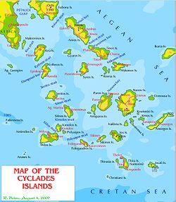
The Cyclades islands comprise around 220 islands and islets. The main islands are indicated in bold below.[7][8]
- Agios Nikolaos (Macheres), 37°59′15″N 24°01′59″E / 37.9875°N 24.03294°E
- Amorgos (141 km2 (54 sq mi)), 36°51′N 25°54′E / 36.850°N 25.900°E[8]
- Ananes, 36°33′06″N 24°08′46″E / 36.55167°N 24.14611°E
- Anafi (40.4 km2 (15.6 sq mi)), 36°22′01″N 25°46′59″E / 36.367°N 25.783°E[8]
- Andros (380 km2 (150 sq mi)), 37°50′11″N 24°53′53″E / 37.83639°N 24.89806°E[8]
- Aniros (Anydros)
- Ano Antikeros
- Antimilos, 36°47′13″N 24°14′19″E / 36.78694°N 24.23861°E
- Antiparos, 37°0′34″N 25°3′39″E / 37.00944°N 25.06083°E[8]
- Anydros Amorgou
- Askania, 36°14′05″N 25°12′48″E / 36.23463°N 25.21327°E[8]
- Christiana (uninhabited), 36°15′N 25°12′E / 36.250°N 25.200°E
- Delos, 37°23′36″N 25°16′16″E / 37.39333°N 25.27111°E[8]
- Despotiko (uninhabited), 36°58′N 25°00′E / 36.96°N 25.00°E
- Donousa (13.8 km2 (5.3 sq mi)), 37°06′0″N 25°48′59″E / 37.10000°N 25.81639°E[8]
- Eschati, 36°13′16″N 25°13′43″E / 36.221177°N 25.228570°E
- Folegandros (32.2 km2 (12.4 sq mi)), 36°37′N 24°54′E / 36.617°N 24.900°E[8]
- Glaronisi, 37°35′09″N 24°45′06″E / 37.58593°N 24.75163°E[9]
- Gyaros, 37°37′38″N 24°43′12″E / 37.62722°N 24.72000°E[8]
- Hristiana
- Htapodia Mykonou
- Ios (108 km2 (42 sq mi)), 36°43′0″N 25°20′11″E / 36.71667°N 25.33639°E[8]
- Iraklia, 36°50′N 25°27′E / 36.833°N 25.450°E[8]
- Kalogiros
- Kardiotissa, 36°38′N 25°01′E / 36.63°N 25.02°E[8]
- Kato Antikeros, 36°50′47″N 25°41′00″E / 36.84641°N 25.68336°E[8]
- Kato Koufonisi, 36°54′48″N 25°34′50″E / 36.9134°N 25.58068°E[8]
- Kea (132 km2 (51 sq mi)), 37°37′23″N 24°20′12″E / 37.62306°N 24.33667°E[8]
- Keros, 36°53′N 25°39′E / 36.89°N 25.65°E[8]
- Kimolos, 36°48′31″N 24°33′47″E / 36.80861°N 24.56306°E[8]
- Kitriani, 36°54′13″N 24°43′34″E / 36.90371°N 24.72623°E[8]
- Koufonisia, 36°56′N 25°36′E / 36.933°N 25.600°E[8]
- Kramvonisi
- Kythnos (99.4 km2 (38.4 sq mi)), 37°23′9″N 24°25′41″E / 37.38583°N 24.42806°E[8]
- Liadi Island, 36°54′13″N 26°10′04″E / 36.90349°N 26.16778°E[8]
- Makares, 37°04′37″N 25°42′02″E / 37.07683°N 25.70055°E[8]
- Makronissos, 37°42′04″N 24°07′29″E / 37.70111°N 24.12472°E
- Megalo, 37°50′55″N 24°45′02″E / 37.84851°N 24.75058°E[8]
- Milos (151 km2 (58 sq mi)), 36°41′N 24°25′E / 36.683°N 24.417°E[8]
- Mykonos, 37°27′32″N 25°21′51″E / 37.45889°N 25.36417°E[8]
- Naxos (429.8 km2 (165.9 sq mi)), 37°05′15″N 25°24′14″E / 37.08750°N 25.40389°E[8]
- Nea Kameni, 36°24′N 25°24′E / 36.400°N 25.400°E[8]
- Nikouria, 36°53′08″N 25°54′32″E / 36.88566°N 25.90892°E[8]
- Nisida Prasini, 37°04′46″N 25°42′21″E / 37.07955°N 25.70586°E[8]
- Ofidousa, 36°32′44″N 26°08′42″E / 36.54561°N 26.14506°E[8]
- Pahia Anaphis
- Palea Kameni, 36°23′51″N 25°22′46″E / 36.39750°N 25.37944°E
- Paros (195 km2 (75 sq mi)), 37°4′N 25°12′E / 37.067°N 25.200°E[8]
- Polyaigos, 36°45′5″N 24°38′11″E / 36.75139°N 24.63639°E
- Rhineia, 37°24′32″N 25°13′44″E / 37.409°N 25.229°E
- Saliagos, 37°02′53″N 25°05′38″E / 37.048°N 25.094°E
- Santorini (Thera), 36°25′N 25°26′E / 36.417°N 25.433°E[8]
- Schoinoussa, 36°52′N 25°31′E / 36.867°N 25.517°E[8]
- Serifopoula, 37°15′22″N 24°36′00″E / 37.256°N 24.6°E
- Serifos, 37°09′N 24°30′E / 37.150°N 24.500°E[8]
- Sifnos, 36°59′21″N 24°40′7″E / 36.98917°N 24.66861°E[8]
- Sikinos, 36°40′32″N 25°6′58″E / 36.67556°N 25.11611°E[8]
- Skilonisi, 37°07′32″N 25°50′00″E / 37.12549°N 25.83347°E[8]
- Stroggyli Parou, 36°57′00″N 24°57′40″E / 36.95004°N 24.96105°E[8]
- Syros, 37°26′18″N 24°54′44″E / 37.43833°N 24.91222°E[8]
- Therasia, 36°26′N 25°20′E / 36.43°N 25.33°E[8]
- Tinos (194 km2 (75 sq mi)), 37°36′48″N 25°08′21″E / 37.61333°N 25.13917°E[8]
- Vous, 37°08′31″N 24°33′43″E / 37.142°N 24.562°E
- Vrachoi Bouvais, 37°13′47″N 25°55′24″E / 37.22972°N 25.92333°E[8]
Dodecanese islands edit


There are 164 total Dodecanese Islands of which 26 are inhabited. There are 12 main islands, as listed in bold below:
- Agathonissi, 37°27.5′N 26°58′E / 37.4583°N 26.967°E
- Agioi Theodoroi Halkis
- Agreloussa
- Alimia, 36°16′N 27°42′E / 36.267°N 27.700°E
- Antitilos
- Anydros Patmou
- Arefoussa
- Arhangelos
- Arkoi, 37°23′N 26°44′E / 37.38°N 26.74°E
- Armathia, 35°26′12″N 26°51′49″E / 35.43667°N 26.86361°E
- Astakida
- Astypalaia, 36°33′N 26°21′E / 36.550°N 26.350°E
- Faradonesia
- Farmakonisi, 37°17′N 27°05′E / 37.283°N 27.083°E
- Fokionissia
- Fragos
- Gaidourosnissi Tilou
- Glaros Kinarou
- Gyali, 36°39′43″N 27°06′54″E / 36.662°N 27.115°E
- Halavra
- Halki, 36°14′N 27°34′E / 36.233°N 27.567°E
- Hiliomodi Patmou
- Hondro
- Htenies
- Imia (uninhabited), 37°03′03″N 27°09′04″E / 37.05083°N 27.15111°E
- Kalavros Kalymnou
- Kalolimnos, 37°03′40″N 27°05′15″E / 37.06111°N 27.08750°E
- Kalovolos
- Kalymnos, 36°59′24″N 26°59′06″E / 36.99000°N 26.98500°E
- Kamilonisi
- Kandeloussa
- Karavolas Rodhou
- Karpathos (300 km2 (120 sq mi)), 35°35′N 27°08′E / 35.583°N 27.133°E
- Kasos, 35°23′51″N 26°55′30″E / 35.39750°N 26.92500°E
- Kastellorizo (Megisti), 36°08′42″N 29°35′06″E / 36.14500°N 29.58500°E
- Kinaros, 36°58′49″N 26°17′23″E / 36.98028°N 26.28972°E
- Kos (290.3 km2 (112.1 sq mi)), 36°51′N 27°14′E / 36.850°N 27.233°E
- Koubelonisi
- Kouloundros
- Kouloura Leipson
- Kounoupoi
- Koutsomytis
- Leipsoi, 37°18′N 26°45′E / 37.300°N 26.750°E
- Leros, 37°09′N 26°51′E / 37.150°N 26.850°E
- Levitha, 37°00′40″N 26°27′35″E / 37.01111°N 26.45972°E
- Makronisi Leipson
- Makronissi Kasou
- Makry Aspronisi Leipson
- Makry Halkis
- Marathos, 37°22′03″N 26°43′30″E / 37.36750°N 26.72500°E
- Marmaras
- Mavra Levithas
- Megalo Aspronisi Leipson
- Megalo Glaronisi
- Megalo Sofrano
- Mesonisi Seirinas
- Mikro Glaronisi, 37°05′23″N 26°53′09″E / 37.08968°N 26.88578°E[10]
- Mikro Sofrano, 36°02′50″N 26°24′34″E / 36.04717°N 26.40941°E[11]
- Nerónisi, 37°28′37″N 26°59′48″E / 37.47698°N 26.99671°E[12]
- Nimos, 37°22′03″N 26°43′30″E / 37.36750°N 26.72500°E
- Nisídes Adelfoí, 36°25′12″N 26°36′32″E / 36.41998°N 26.60881°E
- Nisyros, 36°35′N 27°10′E / 36.583°N 27.167°E
- Paheia Nisyrou
- Patmos, 37°19.5′N 26°32.5′E / 37.3250°N 26.5417°E
- Pergoussa
- Piganoussa
- Pitta
- Plati Kasou
- Plati Pserimou
- Plati Symis
- Pontikoussa
- Prasonissi Rodhou
- Prasouda
- Pserimos, 36°56′0″N 27°8′0″E / 36.93333°N 27.13333°E
- Ro, 36°09′19″N 29°29′50″E / 36.15528°N 29.49722°E
- Rhodes (1,401 km2 (541 sq mi)), 36°10′N 27°56′E / 36.167°N 27.933°E
- Safonidi
- Saria, 35°52′N 27°13′E / 35.87°N 27.22°E
- Seirina
- Sesklio
- Stroggyli
- Strongyli Megistis (Easternmost point of Greece), 36°7′N 29°38′E / 36.117°N 29.633°E
- Strongyli Kritinias
- Strongyli Kasou
- Symi, 36°35′N 27°50′E / 36.583°N 27.833°E
- Syrna, 36°20.33′N 26°40.38′E / 36.33883°N 26.67300°E
- Telendos, 37°00′N 26°55′E / 37.000°N 26.917°E
- Tilos, 36°26′N 27°22′E / 36.433°N 27.367°E
- Tragonisi
- Zaforas, 36°04′24″N 26°24′02″E / 36.0732°N 26.4005°E
Euboea and surrounding islands edit
- Atalanti (uninhabited), 38°40′30″N 23°05′46″E / 38.675°N 23.096°E
- Euboea, 38°30′N 24°00′E / 38.500°N 24.000°E
- Hersonisi
- Kavalliani (uninhabited), 38°40′30″N 23°05′46″E / 38.675°N 23.096°E
- Lichades, 38°49′14″N 22°49′04″E / 38.8205°N 22.8177°E
- Lithari
- Mandilou
- Monoliá, 38°49′26″N 22°49′02″E / 38.82383°N 22.81723°E
- Megalos Petalios
- Petalioi (10 small uninhabited islands/islets), 38°00′42″N 24°15′49″E / 38.0116°N 24.2636°E
- Stouronisi, 38°10′15″N 24°09′39″E / 38.170722°N 24.160917°E
North Aegean islands edit
- Agios Efstratios, 39°31′N 25°00′E / 39.517°N 25.000°E
- Chios, 38°22′39″N 26°03′54″E / 38.37750°N 26.06500°E
- Icaria, 37°35′N 26°10′E / 37.583°N 26.167°E
- Lesbos, 39°12′36″N 26°16′48″E / 39.21000°N 26.28000°E
- Lemnos, 39°55′N 25°15′E / 39.917°N 25.250°E
- Oinousses, 38°31′N 26°13′E / 38.517°N 26.217°E
- Pasas, 38°30′30″N 26°17′10″E / 38.50833°N 26.28611°E
- Psara, 38°33′N 25°34′E / 38.550°N 25.567°E
- Antipsara, 38°32′31″N 25°30′43″E / 38.542°N 25.512°E
- Samos, 37°45′N 26°50′E / 37.750°N 26.833°E
- Samiopoula, 37°37′41″N 26°47′38″E / 37.628°N 26.794°E
- Fournoi Korseon (37°34′N 26°30′E / 37.567°N 26.500°E)
- Agios Minas (37°35′53″N 26°33′14″E / 37.598°N 26.554°E)
- Thymaina (37°35′N 26°26′E / 37.58°N 26.44°E)
There are also two North Aegean islands in the Thracian Sea:
- Samothrace, 40°29′N 25°31′E / 40.483°N 25.517°E
- Thassos, 40°41′N 24°39′E / 40.683°N 24.650°E
Sporades islands edit

The 30 islands in the Sporades are listed below with the four major islands in bold. The largest Sporades island is Skyros.
- Adelfoi Islets, 39°07′N 23°59′E / 39.12°N 23.98°E
- Agios Georgios Skopelou
- Alonissos (64 km2 (25 sq mi)), 39°9′N 23°50′E / 39.150°N 23.833°E
- Arkos (Skiathos Municipality), 39°09′02″N 23°31′04″E / 39.15049°N 23.51768°E
- Aspronisi (Skiathos Municipality)
- Dasia
- Erinia (Rineia Skyrou), 38°49′48″N 24°25′59″E / 38.83°N 24.433°E
- Gioura, 39°23′N 24°10′E / 39.39°N 24.17°E
- Grammeza, 39°20′30″N 24°08′17″E / 39.34177°N 24.13792°E
- Korakas Alonissou
- Kyra Panagia, 39°20′N 24°04′E / 39.33°N 24.07°E
- Lekhoussa, 39°13′45″N 23°59′56″E / 39.22907°N 23.99875°E
- Manolas Alonissou
- Maragos (Skiathos Municipality)
- Peristera, 39°11′N 23°58′E / 39.18°N 23.97°E
- Piperi, 39°20′53″N 24°19′26″E / 39.348°N 24.324°E
- Polemika Alonissou
- Praso Skantzouras
- Psathoura, 39°29′53″N 24°10′52″E / 39.498°N 24.181°E
- Repi, 39°08′49″N 23°31′44″E / 39.147°N 23.529°E
- Sarakino, 38°45′18″N 24°36′36″E / 38.755°N 24.610°E
- Skandili, 39°02′55″N 24°04′54″E / 39.04853°N 24.08154°E[5]
- Skantzoura, 39°05′N 24°07′E / 39.08°N 24.11°E
- Skiathos (49.9 km2 (19.3 sq mi) in Municipality), 39°10′N 23°29′E / 39.167°N 23.483°E
- Skopelos (96 km2 (37 sq mi)), 39°7′N 23°43′E / 39.117°N 23.717°E
- Skyropoula (Skyros Municipality), 38°50′N 24°22′E / 38.84°N 24.36°E
- Skyros (209 km2 (81 sq mi)), 38°53′N 24°31′E / 38.883°N 24.517°E
- Tsougria (Skiathos Municipality), 39°07′N 23°30′E / 39.12°N 23.50°E
- Troulonisi (Skiathos Municipality)
- Tsougriaki (Skiathos Municipality)
- Valaxa, 38°49′N 24°29′E / 38.82°N 24.49°E
Ionian Sea islands edit

Islands in the Ionian Sea are listed below. The seven largest and most popular islands are listed in bold.[13][14]
- Antikythera, 35°52′N 23°18′E / 35.867°N 23.300°E
- Antipaxos, 39°08′57.40″N 20°13′53.98″E / 39.1492778°N 20.2316611°E
- Arkoudi, 38°33′00″N 20°42′25″E / 38.550°N 20.707°E
- Atokos, 38°29′17″N 20°48′43″E / 38.488°N 20.812°E
- Cephalonia, 38°15′00″N 20°35′00″E / 38.25°N 20.58333°E
- Corfu, 39°35′N 19°52′E / 39.583°N 19.867°E
- Diaplo, 39°46′04″N 19°35′33″E / 39.76767°N 19.59261°E
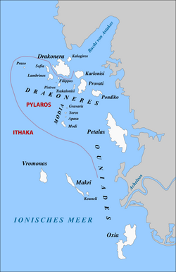
- Echinades
- Apasa, 38°25′53″N 21°1′29″E / 38.43139°N 21.02472°E
- Drakonera, 38°28′48″N 21°01′08″E / 38.480°N 21.019°E
- Filippos, 38°28′17″N 21°0′55″E / 38.47139°N 21.01528°E
- Girovaris or Gkravaris, 38°26′24″N 21°1′36″E / 38.44000°N 21.02667°E
- Kalogiros, 38°29′28″N 21°01′48″E / 38.491°N 21.030°E
- Karlonisi, 38°28′30″N 21°02′35″E / 38.475°N 21.043°E
- Kouneli or Makropoula, 38°21′6″N 21°3′17″E / 38.35167°N 21.05472°E
- Lamprinos, 38°28′23″N 21°00′18″E / 38.473°N 21.005°E
- Makri, 38°21′43″N 21°02′02″E / 38.362°N 21.034°E
- Modio or Modi, 38°25′25″N 21°1′20″E / 38.42361°N 21.02222°E
- Oxeia, 38°18′07″N 21°06′32″E / 38.302°N 21.109°E
- Petalas, 38°24′50″N 21°05′31″E / 38.414°N 21.092°E
- Pistros, 38°27′50″N 21°00′58″E / 38.464°N 21.016°E
- Pontikos, 38°27′18″N 21°03′58″E / 38.455°N 21.066°E
- Praso, 38°28′58″N 20°58′10″E / 38.48278°N 20.96944°E
- Provati, 38°27′48″N 21°2′53″E / 38.46333°N 21.04806°E
- Sofía, 38°28′44″N 21°00′04″E / 38.479°N 21.001°E
- Soros, 38°26′5″N 21°1′30″E / 38.43472°N 21.02500°E
- Tsakalonisi, 38°27′44″N 21°2′11″E / 38.46222°N 21.03639°E
- Vromonas, 38°22′08″N 20°59′42″E / 38.369°N 20.995°E
- Elafonissos, 36°29′15″N 22°57′45″E / 36.48750°N 22.96250°E
- Ereikoussa, 39°53′N 19°35′E / 39.883°N 19.583°E
- Ithaca, 38°22′N 20°43′E / 38.367°N 20.717°E
- Kalamos, 38°37′N 20°55′E / 38.617°N 20.917°E
- Kastos, 38°34′N 20°55′E / 38.567°N 20.917°E
- Kravia, 39°43′42″N 19°38′05″E / 39.72839°N 19.63481°E
- Kythira, 36°15′27″N 22°59′51″E / 36.25750°N 22.99750°E
- Kythros, 38°35′07″N 20°47′58″E / 38.58522°N 20.79953°E
- Lazaretto, 38°22′06″N 20°42′45″E / 38.3683°N 20.7126°E
- Lefkada, 38°43′N 20°39′E / 38.717°N 20.650°E
- Madouri (Uninhabited), 38°42′25″N 20°43′30″E / 38.707°N 20.725°E
- Makropoúla, 38°21′03″N 21°03′16″E / 38.35074°N 21.0544°E
- Mathraki, 39°46′N 19°31′E / 39.767°N 19.517°E
- Meganisi, 38°40′N 20°47′E / 38.667°N 20.783°E
- Modia Islets, 38°25′59″N 21°01′27″E / 38.43298°N 21.0243°E
- Nisída Ágios Nikólaos, 39°24′20″N 20°13′39″E / 39.40564°N 20.22747°E
- Omfori (Uninhabited, private), 38°30′00″N 20°30′00″E / 38.5000°N 20.5000°E
- Othonoi (westernmost point of Greece), 39°51′N 19°24′E / 39.850°N 19.400°E
- Paxi, 39°12′N 20°10′E / 39.200°N 20.167°E
- Provati, 38°27′47″N 21°02′49″E / 38.463°N 21.047°E
- Proti, 37°03′N 21°33′E / 37.050°N 21.550°E
- Sapientza, 36°46′18.3″N 21°42′18.1″E / 36.771750°N 21.705028°E
- Schiza (Uninhabited), 36°43′38″N 21°46′08″E / 36.72722°N 21.76889°E
- Skorpios, 38°41′31″N 20°44′35″E / 38.692°N 20.743°E
- Skorpidi (Private), 38°41′30″N 20°44′30″E / 38.6917°N 20.7417°E
- Sparti Lefkados, 38°42′57″N 20°44′38″E / 38.71585°N 20.74378°E
- Sphacteria, 36°55′48.49″N 21°39′56.61″E / 36.9301361°N 21.6657250°E
- Strofades, 37°15′N 21°00′E / 37.250°N 21.000°E
- Thilia, 38°39′28″N 20°43′59″E / 38.65789°N 20.733°E
- Vido, 39°38′30″N 19°55′30″E / 39.64167°N 19.92500°E
- Zakynthos, 37°48′N 20°45′E / 37.800°N 20.750°E
Islets close to mainland edit
The following islands are close to the mainland and not part of a sea:
- Alatas Trikeriou, 39°09′38″N 23°12′21″E / 39.16053°N 23.20578°E
- Ammouliani (Chalkidiki), 40°20′N 23°55.2′E / 40.333°N 23.9200°E
- Antitrikeri (Thessaly)
- Kelyfos, 40°03′42″N 23°43′34″E / 40.06174°N 23.7261°E
- Paleo Trikeri (Thessaly), 39°10′00″N 23°05′00″E / 39.16667°N 23.08333°E
- Trizonia island (Central Greece), 38°22′01″N 22°04′23″E / 38.367°N 22.073°E
Islands not in the sea edit
Lake and river islands edit

- Agios Achilleios (Small Prespa Lake), 40°46′59″N 21°05′03″E / 40.78294°N 21.08407°E
- Ioannina Island (Lake Pamvotida), 39°40′39″N 20°52′30″E / 39.67750°N 20.87500°E
- Vidronisi (Small Prespa Lake), 40°45′20″N 21°06′14″E / 40.75563°N 21.10377°E
- Anonymous islet (Limnothálassa Pápas lagoon, Western Achaia), 38°11′46″N 21°23′37″E / 38.19623°N 21.39368°E
Islands in an island edit
- Marathi Island (Marathi Lake (reservoir) in Mykonos), 37°28′00.8″N 25°21′31.9″E / 37.466889°N 25.358861°E
Lagoon islands edit
- Aitoliko Lagoon
- Aitoliko, 38°26′13″N 21°21′12″E / 38.43694348437774°N 21.353464108512995°E
- Missolonghi Lagoon
- Dolmas
- Kleisova, 38°20′57″N 21°26′09″E / 38.34924°N 21.43586°E
- Komma, 38°19′24″N 21°21′41″E / 38.32325°N 21.36138°E
- Prokopanistos
- Schinias
- Tourlida, 38°19′43″N 21°24′57″E / 38.3286795°N 21.4158223°E
- Vasiladi, 38°20′21″N 21°23′04″E / 38.33908°N 21.38439°E
See also edit
Notes edit
- ^ In Greek: Island-Νησί (Nisi), Islet-Νησάκι (Nisáki)
References edit
- ^ John S. Bowman; Sherry Marker; Peter Keraislands siotis; Heidi Sarna (2010). "Greece in depth". Frommer's Greece (7th ed.). Hoboken, NJ: Wiley Publishing. p. 12. ISBN 978-0-470-52663-7.
- ^ a b "Islands". Visit Greece - Official website of the Greek National Tourism Organisation. Hellenic Organization of Tourism (EOT; Ελληνικός Οργανισμός Τουρισμού). Retrieved 7 February 2022.
- ^ Poffley, Frewin (20 December 2012). Greek island hopping, 23rd ed. 2013. Thomas Cook Publishing. p. 15. ISBN 978-1-84848-569-3. OCLC 827800689.
- ^ Google Maps
- ^ a b "Islands of Greece". GeoNames. Retrieved 6 November 2021.
- ^ "Nisida Agio Pantes". GeoNames. Retrieved 10 November 2021.
- ^ "Tageo Worldwide Index for Greece Islands". Tageo, www.tageo.com. Retrieved 24 March 2020.(in English)
- ^ a b c d e f g h i j k l m n o p q r s t u v w x y z aa ab ac ad ae af ag ah ai aj ak al am an ao ap aq "Islands of the Cyclades". GeoNames. Retrieved 13 November 2021.
- ^ "Glaronisi, South Aegean". GeoNames. Retrieved 10 November 2021.
- ^ "Mikro Glaronisi". GeoNames. Retrieved 10 November 2021.
- ^ "Mikro Sofrano". GeoNames. Retrieved 10 November 2021.
- ^ "Nerónisi". GeoNames. Retrieved 10 November 2021.
- ^ "Ionian Islands of Greece". GeoNames. Retrieved 12 November 2021.
- ^ Kruse, Hellas, vol. ii. pt. ii. p. 455, seq.; Leake, Northern Greece, vol. iii. pp. 30, seq., 50, seq.; Mure, Tour in Greece, vol. i. p. 104.
- "List of all Greek island". the Island Voyager. 24 February 2021. Retrieved 12 November 2021.
- "List of Greek Islands". Sailing Heaven. 26 October 2015. Retrieved 12 November 2021.
- Richard Talbert (2000). Richard J. A. Talbert (ed.). Barrington Atlas Map-by-Map Directory (Two-Volumes). Princeton University Press. ISBN 0-691-04945-9., Barrington Atlas of the Greek and Roman World
External links edit
 Greek Islands travel guide from Wikivoyage