
KNOWPIA
WELCOME TO KNOWPIA

List of lighthouses in Washington 
Summary
This is a list of all lighthouses in the U.S. state of Washington as identified by the United States Coast Guard.[1] There are eighteen active lights in the state; three are standing but inactive, three were supplanted by automated towers, and two have been completely demolished. Two lights, one of them still active, serve as museums.
The Cape Disappointment Light was the first lighthouse in the state (lit 1856) and is still active.[2]
If not otherwise noted, focal height and coordinates are taken from the United States Coast Guard Light List,[3] while location and dates of activation, automation, and deactivation are taken from the United States Coast Guard Historical information site for lighthouses.[1]
| Name | Image | Location | Coordinates | Year first lit | Automated | Year deactivated | Current Lens | Focal Height |
|---|---|---|---|---|---|---|---|---|
| Admiralty Head Light | 
|
Coupeville | 48°09′39″N 122°40′52″W / 48.1608°N 122.6810°W[4] | 1861 (Former) 1903 (Current) |
Never | 1922 (Now a museum) |
None | 120 ft (37 m) |
| Alki Point Light | 
|
West Seattle | 47°34′35″N 122°25′14″W / 47.5763°N 122.4206°W | 1913 | 1984 | Active | VRB-25 | 39 ft (12 m) |
| Browns Point Light | 
|
Browns Point | 47°18′21″N 122°26′39″W / 47.3059°N 122.4443°W | 1887 (First) 1933 (Current) |
1963 | Active | VRB-25 | 38 ft (12 m) |
| Burrows Island Light | 
|
Anacortes (Burrows Island) |
48°28′40″N 122°42′49″W / 48.4779°N 122.7135°W | 1906 | 1972 | Active | Optic | 57 ft (17 m) |
| Bush Point Light | Coupeville | 48°01′51″N 122°36′25″W / 48.03087°N 122.60697°W | 1894 (Former) 1933 (Current) |
1933 | Active | Unknown | Unknown | |
| Cape Disappointment Light | 
|
Cape Disappointment | 46°16′33″N 124°03′08″W / 46.2758°N 124.0522°W | 1856 | 1973 | Active | Fourth-order Fresnel | 220 ft (67 m) |
| Cape Flattery Light | 
|
Tatoosh Island | 48°23′31″N 124°44′13″W / 48.3919°N 124.7370°W | 1857 | 1977 | 2009[2] (Replaced with skeleton tower) |
None | 165 ft (50 m) |
| Cattle Point Light | 
|
San Juan Island[5] | 48°27′02″N 122°57′48″W / 48.4506°N 122.9633°W | 1888 (Former) 1935 (Current) |
1950s | Active | Unknown | Unknown |
| Clover Island Light | 
|
Kennewick | 46°13′01″N 119°06′40″W / 46.217°N 119.111°W | 2010[6] | Always | Active | LED | 62 ft (19 m) |
| Destruction Island Light | 
|
Destruction Island | 47°40′28″N 124°29′13″W / 47.6745°N 124.4869°W[7] | 1892 | 1968 | 2008[7] | None | 165 ft (50 m)[8] |
| Dofflemyer Point Light | 
|
Boston Harbor | 47°08′26″N 122°54′26″W / 47.1405°N 122.9073°W | 1887[9] (Former) 1934[9] (Current) |
1987[9] | Active | Unknown | 30 ft (9.1 m) |
| Ediz Hook Light | 
|
Port Angeles (Air Station) |
48°08′24″N 123°24′08″W / 48.1401°N 123.4023°W | 1865[10] (First) 1908[10] (Last) |
Never | 1946[10] (Replaced with skeleton tower) |
None | Unknown |
| Grays Harbor Light | 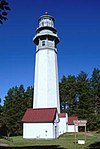
|
Westport | 46°53′18″N 124°07′01″W / 46.8882°N 124.1169°W | 1898 | 1945 | Active | Third-order Fresnel | 123 ft (37 m) |
| Lime Kiln Light | 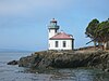
|
San Juan Island | 48°30′58″N 123°09′09″W / 48.5160°N 123.1524°W | 1919 | 1962 | Active | 375mm | 55 ft (17 m) |
| Marrowstone Point Light | 
|
Marrowstone (Fort Flagler State Park) |
48°06′06″N 122°41′16″W / 48.1016°N 122.6879°W | 1888[11] (Former) 1918[11] (Current) |
1962 | Active | Unknown | 28 ft (8.5 m) |
| Mukilteo Light | 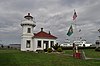
|
Mukilteo | 47°56′55″N 122°18′22″W / 47.9487°N 122.3062°W | 1906 | 1979 | Active (Also a museum) |
Fourth-order Fresnel | 33 ft (10 m) |
| New Dungeness Light | 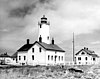
|
Sequim (Dungeness Spit) |
48°10′54″N 123°06′37″W / 48.1817°N 123.1103°W | 1857 | 1994[12] | Active | VRB-25 acrylic lens | 67 ft (20 m) |
| North Head Light | 
|
Ilwaco | 46°17′56″N 124°04′41″W / 46.2989°N 124.0780°W | 1898 | 1961 | Active | VRB-25 | 194 ft (59 m) |
| Patos Island Light | 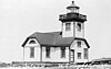
|
Patos Island | 48°47′20″N 122°58′17″W / 48.7890°N 122.9713°W | 1893[13] (Former) 1908[13] (Current) |
1974 | Active | Unknown | 52 ft (16 m) |
| Point No Point Light | 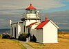
|
Hansville (Point No Point) |
47°54′44″N 122°31′36″W / 47.9122°N 122.5268°W | 1880 | 1977 | Active | Plastic | 27 ft (8.2 m) |
| Point Roberts Light | Point Roberts | 48°58′17″N 123°04′58″W / 48.9715°N 123.0827°W | Unknown | Unknown | Active? | Unknown | Unknown | |
| Point Robinson Light | 
|
Vashon (Point Robinson) |
47°23′17″N 122°22′28″W / 47.3881°N 122.3744°W | 1887[14] (Former) 1915[14] (Current) |
1978 | Active | Plastic | 40 ft (12 m) |
| Point Wilson Light | 
|
Port Townsend | 48°08′39″N 122°45′17″W / 48.1442°N 122.7548°W | 1879 (Former) 1914 (Current) |
1976 | Active | Fourth-order Fresnel | 51 ft (16 m) |
| Semiahmoo Harbor Light | 
|
Blaine | 48°59′32″N 122°47′02″W / 48.9923°N 122.7840°W | 1905 | Never | 1944 (Demolished) |
None | Unknown |
| Skunk Bay Light | Port Ludlow | Latitude: 47.91925, Longitude: -122.56981 | 1965 (Faux) |
Always | Active | Unknown | Unknown | |
| Slip Point Light | 
|
Clallam Bay | 48°15′52″N 124°15′04″W / 48.2645°N 124.251°W[15] | 1905[15] (First) 1951[15] (Last) |
1977[15] | 2000[15] (Removed) |
None | 55 ft (17 m)[16] |
| Smith Island Light | 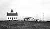
|
Smith Island | 48°19′06″N 122°50′38″W / 48.3184°N 122.8438°W | 1858[2] | 1957[2] | 1998[17] (Destroyed) |
None | 97 ft (30 m) |
| Turn Point Light | 
|
Stuart Island | 48°41′20″N 123°14′15″W / 48.6888°N 123.2374°W | 1893 (Former) 1936 (Current) |
1974 | Active | 300mm | 44 ft (13 m) |
| West Point Light | 
|
Seattle (West Point) |
47°39′43″N 122°26′09″W / 47.6620°N 122.4357°W | 1881 | 1985 | Active | VRB-25 | 27 ft (8.2 m) |
| Willapa Bay Light | 
|
Willapa Bay | 46°43′N 124°05′W / 46.71°N 124.08°W (Estimate) |
1858[18] | Never | 1938[18] (Demolished) |
None | 81 ft (25 m)[19] |
References edit
- ^ a b "Historic Light Station Information and Photography: Washington". United States Coast Guard Historian's Office. Archived from the original on 2017-05-01.
- ^ a b c d Rowlett, Russ. "Lighthouses of the United States: Washington". The Lighthouse Directory. University of North Carolina at Chapel Hill.
- ^ Light List, Volume VI, Pacific Coast and Pacific Islands (PDF). Light List. United States Coast Guard. 2012.
- ^ "Admiralty Head, WA". LighthouseFriends. Archived from the original on 2013-08-17.
- ^ "Cattle Point, WA". LighthouseFriends. Archived from the original on 2015-05-05.
- ^ "Clover Island Lighthouse & Lighthouse Plaza". portofkennewick.org. Retrieved October 4, 2017.
- ^ a b "Destruction Island, WA". LighthouseFriends.
- ^ Columbia River to Destruction Island (Map). 1:180,789. NOAA. 2004. 18500. Archived from the original on 2016-03-04. Retrieved 2012-05-07.
- ^ a b c "Dofflemyer Point, WA". LighthouseFriends. Archived from the original on 2015-05-05.
- ^ a b c "Ediz Hook, WA". LighthouseFriends. Archived from the original on 2010-02-02.
- ^ a b "Marrowstone Point, WA". LighthouseFriends.
- ^ "New Dungeness, WA". LighthouseFriends. Archived from the original on 2010-03-23.
- ^ a b "Patos Island, WA". LighthouseFriends.
- ^ a b "Point Robinson, WA". LighthouseFriends. Archived from the original on 2015-05-05.
- ^ a b c d e "Slip Point, WA". LighthouseFriends. Archived from the original on 2012-01-25.
- ^ Strait of Juan de Fuca Entrance (Map). 1:100,000. NOAA. 1998. Chart 18460. Archived from the original on 2015-05-27. Retrieved 2012-05-09.
- ^ Nelson, Sharlene (January 1999). "And, now there are three: The Demise of the Smith Island Light". Lighthouse Digest.
- ^ a b Harrison, Tim; Jones, Ray (2000). Lost Lighthouses. Guilford, Connecticut: Globe Pequot Press. p. 128.
willapa bay lighthouse.
- ^ Willapa Bay (Map). 1:40,000. US Dept. of Commerce. 1928. Chart 6185. Archived from the original on 2017-10-06. Retrieved 2012-05-10.