


Summary
Lower Longley is a rural locality situated on the borders of the Kingborough and Huon Valley local government areas, which straddles the Huon Highway and is made up primarily of acreage properties. Lower Longley had 131 inhabitants as of the 2011 Australian Census.[2] Despite being called Lower Longley, the suburb is physically higher than neighbouring Longley.
| Lower Longley Hobart, Tasmania | |||||||||||||||
|---|---|---|---|---|---|---|---|---|---|---|---|---|---|---|---|
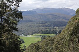 The highest point of the Huon Highway at Vinces Saddle in Lower Longley | |||||||||||||||
 | |||||||||||||||
| Population | 267 (SAL 2021)[1] | ||||||||||||||
| Postcode(s) | 7109 | ||||||||||||||
| LGA(s) | Huon Valley, Kingborough. | ||||||||||||||
| State electorate(s) | |||||||||||||||
| Federal division(s) | |||||||||||||||
| |||||||||||||||
History edit
The Lower Longley State School was opened some time before 1900, before being replaced by a newer school in 1941 after complaints of the conditions at the school being "disgraceful"[3][4] The school closed at some point.
Lower Longley has had numerous churches in its history, including a Wesleyan church opened 1890[5] however the last church in Lower Longley was burnt down in the 1967 fires and relocated afterwards to Sandfly to become St. Lukes.
In 1898 the township of Lower Longley was mostly destroyed in a severe fire[6]
Lower Longley includes a town hall[7] – the original of which was opened in 1907[8] by the Premier of Tasmania and later replaced after the 1967 bushfires which destroyed the original building. There remains an early 20th-century Methodist cemetery, orphaned following the loss of its church in the same fire.[9][10]
Lower Longely is home to the transmission sites for 87.8 Pulse FM Kingborough and Huon and 98.5 Huon FM on Mt Herringback. Mt Herringback in Lower Longely is also the main communications hub for the Huon Valley, with all Optus, Vodafone, Telstra, NBN and Tasmanet voice, SMS and data traffic for the Huon Valley passing through Mt Herringback.[11]
References edit
- ^ Australian Bureau of Statistics (28 June 2022). "Lower Longley (suburb and locality)". Australian Census 2021 QuickStats. Retrieved 28 June 2022.
- ^ "2011 Census QuickStats: Lower Longley". Censusdata.abs.gov.au. Retrieved 5 August 2013.
- ^ "21 Jun 1939 - LOWER LONGLEY SCHOOL Proposed Removal". Trove.nla.gov.au. 21 June 1939. Retrieved 5 August 2013.
- ^ "06 May 1941 - The Huon NEW SCHOOL AT LONGLEY Opening Ceremony". Trove.nla.gov.au. 6 May 1941. Retrieved 5 August 2013.
- ^ "29 Oct 1890 - OPENING OF NEW WESLEYAN CHURCH, LOWER LONGLEY. [". Trove.nla.gov.au. Retrieved 5 August 2013.
- ^ "03 Jan 1898 - THE BUSH FIRES. LONGLEY AND SANDELY IN ASHES. SE". Trove.nla.gov.au. Retrieved 5 August 2013.
- ^ "Kingborough Council - Council Venues for Hire - Tasmania". Kingborough.tas.gov.au. Retrieved 5 August 2013.
- ^ "25 Mar 1907 - LOWER LONGLEY. PREMIER OPENS NEW PUBLICHALL". Trove.nla.gov.au. 25 March 1907. Retrieved 5 August 2013.
- ^ "Tasmania -Lower Longley Methodist Headstones". Australian Cemeteries. Retrieved 5 August 2013.
- ^ "Kingborough Council - Cemeteries in Kingborough - Tasmania". Kingborough.tas.gov.au. Retrieved 5 August 2013.
- ^ "ACMA Register of Radiocommunications Licences - Mt Herringback". acma.gov.au. Retrieved 18 June 2018.
42°58′39″S 147°08′29″E / 42.97750°S 147.14139°E