Summary
Mashhad County (Persian: شهرستان مشهد) is in Razavi Khorasan province, Iran. Its capital is the city of Mashhad, which is also the capital of the province.[3]
Mashhad County
Persian: شهرستان مشهد | |
|---|---|
County | |
 Imam Reza | |
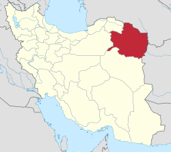
 Location of Mashhad County in Razavi Khorasan province (top right, green) | |
 Location of Razavi Khorasan province in Iran | |
| Coordinates: 36°21′31″N 59°49′38″E / 36.35861°N 59.82722°E[1] | |
| Country | |
| Province | Razavi Khorasan |
| Capital | Mashhad |
| Districts | Central, Ahmadabad, Razaviyeh |
| Area | |
| • Total | 9,169 km2 (3,540 sq mi) |
| Population (2016)[2] | |
| • Total | 3,372,660 |
| • Density | 370/km2 (950/sq mi) |
| Time zone | UTC+3:30 (IRST) |
| Mashhad County at GEOnet Names Server | |
At the 2006 census, the county's population was 2,848,637, in 746,652 households.[4] The following census in 2011 counted 3,069,941 people in 889,034 households,[5] by which time Torqabeh District had been separated from the county in the establishment of Binalud County (now Torqabeh and Shandiz County).[6] At the 2016 census, Mashhad County's population was 3,372,660, in 1,021,068 households.[2] It is the most populous county in the province and the second most populous in the country, behind Tehran County.
Administrative divisions edit
The population history and structural changes of Mashhad County's administrative divisions over three consecutive censuses are shown in the following table. The latest census shows three districts, 11 rural districts, and three cities.[2]
| Administrative Divisions | 2006[4] | 2011[5] | 2016[2] |
|---|---|---|---|
| Central District | 2,679,938 | 2,991,644 | 3,280,368 |
| Darzab RD | 12,886 | 12,192 | 13,112 |
| Kardeh RD | 7,096 | 6,115 | 5,354 |
| Kenevist RD | 29,184 | 22,538 | 27,987 |
| Miyan Velayat RD | 20,397 | 23,502 | 29,751 |
| Tabadkan RD | 71,170 | 83,159 | 105,285 |
| Tus RD | 128,405 | 77,880 | 97,695 |
| Mashhad (city) | 2,410,800 | 2,766,258 | 3,001,184 |
| Ahmadabad District | 51,267 | 28,118 | 32,988 |
| Piveh Zhan RD | 17,262 | 17,768 | 20,589 |
| Sarjam RD | 32,844 | 8,863 | 10,343 |
| Binalud (city)1 | |||
| Molkabad (city) | 1,161 | 1,487 | 2,056 |
| Razaviyeh District | 67,093 | 50,169 | 59,232 |
| Abravan RD | 13,561 | 14,209 | 14,905 |
| Meyami RD | 44,348 | 25,070 | 28,890 |
| Pain Velayat RD | 6,399 | 6,348 | 6,587 |
| Razaviyeh (city) | 2,785 | 4,542 | 8,850 |
| Torqabeh District2 | 50,339 | ||
| Shandiz RD | 15,431 | ||
| Torqabeh RD | 15,348 | ||
| Shandiz (city) | 6,402 | ||
| Torqabeh (city) | 13,158 | ||
| Total | 2,848,637 | 3,069,941 | 3,372,660 |
| RD: Rural District 1Became a city after the 2016 census[7] 2Became a part of Torqabeh and Shandiz County | |||
References edit
- ^ OpenStreetMap contributors (4 May 2023). "Mashhad County" (Map). OpenStreetMap. Retrieved 4 May 2023.
- ^ a b c d "Census of the Islamic Republic of Iran, 1395 (2016)". AMAR (in Persian). The Statistical Center of Iran. p. 09. Archived from the original (Excel) on 2 April 2022. Retrieved 19 December 2022.
- ^ Habibi, Hassan (21 June 1369). "Approval of the organization and chain of citizenship of the elements and units of the divisions of Khorasan province, centered in Mashhad". Lamtakam (in Persian). Ministry of Interior, Defense Political Commission of the Government Council. Archived from the original on 27 December 2023. Retrieved 27 December 2023.
- ^ a b "Census of the Islamic Republic of Iran, 1385 (2006)". AMAR (in Persian). The Statistical Center of Iran. p. 09. Archived from the original (Excel) on 20 September 2011. Retrieved 25 September 2022.
- ^ a b "Census of the Islamic Republic of Iran, 1390 (2011)". Syracuse University (in Persian). The Statistical Center of Iran. p. 09. Archived from the original (Excel) on 20 January 2023. Retrieved 19 December 2022.
- ^ Davodi, Parviz (3 December 2014). "Approval letter regarding the reforms of country divisions in Razavi Khorasan province, Mashhad County". Islamic Parliament Research Center (in Persian). Ministry of Interior, Council of Ministers. Archived from the original on 23 November 2015. Retrieved 10 May 2023.
- ^ "Introducing the city". Binalood. Archived from the original on 2 July 2016. Retrieved 4 May 2023.


