
KNOWPIA
WELCOME TO KNOWPIA

Montgomery Peak 
Summary
Montgomery Peak is a mountain in the White Mountains of California, USA. It is less than 1 mile (1.6 km) from Boundary Peak, the highest point in Nevada; and it is taller than Boundary Peak. Boundary Peak has a prominence of less than 300 feet. Montgomery can be climbed in combination with Boundary Peak. The two peaks are in the Inyo National Forest and White Mountains Wilderness.[1] Montgomery Peak is in Mono County (California), and Boundary Peak is in Esmeralda County, in Nevada.
| Montgomery Peak | |
|---|---|
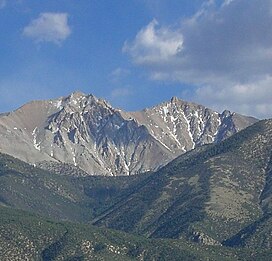 Montgomery Peak (right) and Boundary Peak | |
| Highest point | |
| Elevation | 13,447 ft (4,099 m) NAVD 88[1] |
| Prominence | 1,266 ft (386 m)[1] |
| Listing | |
| Coordinates | 37°50′18″N 118°21′24″W / 37.8382642°N 118.3567847°W[5] |
| Geography | |
 Montgomery Peak | |
| Location | |
| Parent range | White Mountains |
| Topo map | USGS Boundary Peak |
| Climbing | |
| Easiest route | Scramble, class 2[2] |
References edit
- ^ a b c "Montgomery Peak, California". Peakbagger.com. Retrieved 2009-02-17.
- ^ a b "Desert Peaks Section List" (PDF). Angeles Chapter, Sierra Club. Retrieved 2014-02-23.
- ^ "Great Basin Peaks Section List". Toiyabe Chapter, Sierra Club. Retrieved 2021-11-21.
- ^ "Western States Climbers Qualifying Peak List". Climber.org. Retrieved 2021-11-21.
- ^ "Montgomery Peak". Geographic Names Information System. United States Geological Survey, United States Department of the Interior. Retrieved 2009-02-17.