


Summary
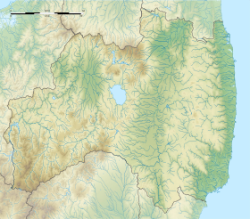
Mount Adatara (安達太良山, Adatara-yama) is a stratovolcano in Fukushima Prefecture, Japan.
| Mount Adatara | |
|---|---|
 Viewed from the SE. | |
| Highest point | |
| Elevation | 1,728 m (5,669 ft)[1] |
| Listing | Volcanoes in Japan |
| Coordinates | 37°38′39″N 140°17′10″E / 37.64417°N 140.28611°E |
| Naming | |
| Native name | 安達太良山 (Japanese) |
| Geography | |
 Mount Adatara Fukushima Prefecture, Honshu, Japan | |
| Parent range | Ōu Mountains |
| Geology | |
| Mountain type | Stratovolcano |
| Last eruption | AD 1900[2] |
It is located about 15 kilometres southwest of the city of Fukushima and east of Mount Bandai. Its last known eruption was in 1996.[1] An eruption in 1900 killed 72 workers at a sulfur mine located in the summit crater.[1]
History edit
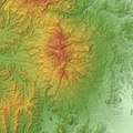
The mountain is actually multiple volcanoes forming a broad, forested massif. It abuts Mount Azuma, a dormant volcano to the north. The peak is called Minowa-yama. It is the highest peak in the Adatara range, which stretches about 9 km in a north-south direction.[3]
The active summit crater is surrounded by hot springs and fumaroles. Sulfur mining was carried out in the 19th century, and 72 mine workers were killed in an eruption in 1900. Poems about Mount Adatara by Kōtarō Takamura from his book "Chieko-sho" helped make it famous.
Gallery edit
-
 Massif of Adatara Volcano
 -
 Numanotaira Crater
 -
 Summit


See also edit
References edit
- ^ a b c "Adatara". Global Volcanism Program. Smithsonian Institution. Retrieved 2014-12-30.
- ^ Adatara Yama - Geological Survey of Japan
- ^ Takeda T., page 92.
- Sources
- Takeda, Toru; Hishinuma, Tomio; Kamieda, Kinuyo; Dale, Leigh; Oguma, Chiyoichi (August 10, 1988). Hello! Fukushima - International Exchange Guide Book (1988 ed.). Fukushima City: Fukushima Mimpo Press.
External links edit
- Adatarayama - Japan Meteorological Agency (in Japanese)
- Adatarayama: National catalogue of the active volcanoes in Japan - Japan Meteorological Agency
- Adatara Yama - Geological Survey of Japan
- Adatarayama: Global Volcanism Program - Smithsonian Institution