
KNOWPIA
WELCOME TO KNOWPIA

Mount Quincy Adams (Fairweather Range) 
Summary
Mount Quincy Adams (alternate Name Boundary Peak 163) is a mountain located on the border between United States and Canada. It is named after John Quincy Adams (1767–1848), the sixth president of the United States.
| Mount Quincy Adams | |
|---|---|
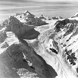 Mount Quincy Adams in upper left, with Mount Tlingit below/left of it. Aerial view by Austin Post. 1972 | |
| Highest point | |
| Elevation | 4,150 m (13,620 ft)[1] |
| Prominence | 410 m (1,350 ft)[1] |
| Listing | |
| Coordinates | 58°54′32″N 137°27′05″W / 58.90889°N 137.45139°W[2] |
| Geography | |
 Mount Quincy Adams  Mount Quincy Adams Mount Quincy Adams (British Columbia) | |
| Parent range | Fairweather Range |
| Topo map | USGS Mount Fairweather D-5 Canada NTS 114I14 Mount Root |
| Climbing | |
| First ascent | Bradford Washburn, H. Adams Carter, 1934[3] |
The southern and eastern flanks of the mountain are in Glacier Bay National Park, in Hoonah-Angoon Census Area, Alaska. The northern and northwestern flanks are in Tatshenshini-Alsek Park, in Stikine Region, British Columbia, making it the second highest peak in British Columbia. Mount Quincy Adams is flanked to the west by Mount Fairweather 4,671 m (15,325 ft).
References edit
- ^ a b "Mount Quincy Adams". Peakbagger.com. Retrieved 2006-10-10.
- ^ "Mount Quincy Adams". Geographic Names Information System. United States Geological Survey, United States Department of the Interior. Retrieved 2006-10-10.
- ^ "Mount Quincy Adams". Bivouac.com. Retrieved 2006-10-10.
External links edit
- Canadian Mountain Encyclopedia: Quincy Adams