


Summary
Mount Stone is a 6,612-foot (2,015 m) peak in the Olympic Mountains. It is the highest point in Mason County, Washington and exceeds 2,000 feet (610 m) in prominence.[1][2][3]
| Mount Stone | |
|---|---|
 Mount Stone | |
| Highest point | |
| Elevation | 6,612 ft (2,015 m) |
| Prominence | 2,132 ft (650 m) |
| Coordinates | 47°36′23″N 123°16′00″W / 47.60632°N 123.266607°W |
| Geography | |
 Mount Stone Location in Washington | |
| Location | Olympic National Park Mason County, Washington, U.S. |
| Parent range | Olympic |
| Topo map | USGS Mount Skokomish |
| Climbing | |
| Easiest route | Scrambling |
Mount Stone can be reached via the North Hamma Hamma Road. Climbing Mount Stone involves a class 3 rock scramble (5000 feet elevation gain, 11 miles roundtrip). This can be done either as a day climb or an overnight trip (camping is available at the Lake of the Angels, ~4900 feet). On a clear day one can view many of the major peaks of the Olympic Mountains, including The Brothers, Mount Washington, Mount Anderson, Mount Deception, Mount Constance, and Mount Olympus.
Climate edit
Based on the Köppen climate classification, Mount Stone is located in the marine west coast climate zone of western North America.[4] Most weather fronts originate in the Pacific Ocean, and travel northeast toward the Olympic Mountains. As fronts approach, they are forced upward by the peaks of the Olympic Range, causing them to drop their moisture in the form of rain or snowfall (Orographic lift). As a result, the Olympics experience high precipitation, especially during the winter months. During winter months, weather is usually cloudy, but, due to high pressure systems over the Pacific Ocean that intensify during summer months, there is often little or no cloud cover during the summer. Because of maritime influence, snow tends to be wet and heavy, resulting in avalanche danger. Precipitation runoff from the mountain drains into tributaries of the Duckabush, Hamma Hamma, and the Skokomish rivers.
Gallery edit
-
 Mount Stone from Mount Ellinor
 -
 Mount Stone seen from Mount Skokomish
 -
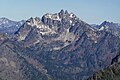
 Mount Stone from Mt. Lena


References edit
- ^ USGS 1:24,000 topographical quad "Mount Skokomish"
- ^ Martin, Andy (1994). County high points: For all western and northeastern states. Old Adit Press. ISBN 0962876216. List maintained at Peakbagger.com
- ^ John Roper (August 2, 1994). "THE HIGH POINTS OF THE 39 COUNTIES OF WASHINGTON". Retrieved 2013-04-21.
- ^ Peel, M. C.; Finlayson, B. L.; McMahon, T. A. (2007). "Updated world map of the Köppen−Geiger climate classification". Hydrol. Earth Syst. Sci. 11. ISSN 1027-5606.
External links edit
- U.S. Geological Survey Geographic Names Information System: Mount Stone
- Mount Stone, peakbagger.com
- Mount Stone, summitpost.org