


Summary
Nadezhdinsky District (Russian: Наде́ждинский райо́н) is an administrative[1] and municipal[7] district (raion), one of the twenty-two in Primorsky Krai, Russia. It is located on the southern coast of the krai. The area of the district is 1,595.7 square kilometers (616.1 sq mi).[4] Its administrative center is the rural locality (a selo) of Volno-Nadezhdinskoye.[3] Population: 39,161 (2010 Russian census);[5] 40,197 (2002 Census);[9] 43,012 (1989 Soviet census).[10] The population of Volno-Nadezhdinskoye accounts for 17.1% of the district's total population.[5]
Nadezhdinsky District
Надеждинский район | |
|---|---|
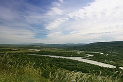 Razdolnaya River, Nadezhdinsky District | |
 Flag  Coat of arms | |
 Location of Nadezhdinsky District in Primorsky Krai | |
| Coordinates: 43°22′N 131°59′E / 43.367°N 131.983°E | |
| Country | Russia |
| Federal subject | Primorsky Krai[1] |
| Established | 1937[2] |
| Administrative center | Volno-Nadezhdinskoye[3] |
| Area | |
| • Total | 1,595.7 km2 (616.1 sq mi) |
| Population | |
| • Total | 39,161 |
| • Estimate (2018)[6] | 38,746 (−1.1%) |
| • Density | 25/km2 (64/sq mi) |
| • Urban | 0% |
| • Rural | 100% |
| Administrative structure | |
| • Inhabited localities[1] | 34 rural localities |
| Municipal structure | |
| • Municipally incorporated as | Nadezhdinsky Municipal District[7] |
| • Municipal divisions[7] | 0 urban settlements, 3 rural settlements |
| Time zone | UTC+10 (MSK+7 |
| OKTMO ID | 05623000 |
| Website | http://nadezhdinsky.ru/ |
Geography edit
The Razdolnaya River crosses the territory of the district. Despite the high density of the population, close location to the large city, and the developed road network, Nadezhdinsky District boasts the unique nature attractions such as the yew (Taxus cuspidata) grove with an area of 400,000 square meters (4,300,000 sq ft), and Korean pine forests.
History edit
The district was established in 1937.[2]
Economy edit
The favorable climatic conditions and closeness to Vladivostok (the administrative center of the krai) predetermined the district's specialization. There are seven agricultural enterprises which provide Vladivostok with meat, milk, eggs, vegetables, and potatoes. Mink, foxes, polecats, and deer are bred in the district.
For more than a hundred years, the brown coal deposits have been exploited in the territory of the district (Tavrichanskoye Deposit), and construction sand in the Razdolnaya River Valley has been the raw material for silicate brick production. The Razdolnensky Construction Materials Plant, which is one of the district's largest enterprises, is involved in the production of bricks. There are deposits of porous basalt, which is the raw material used by Terekhovsky Concrete Production Plant. Not far from Kiparisovo railway station are beds of sandstone which is the quartz-containing raw materials used by the glass industry. The largest glassworks in Primorsky Krai is located here.
Transportation edit
A federal road connects the settlement of Razdolnoye with Khasan, located on the North Korea–Russia border.
References edit
Notes edit
- ^ a b c Law #161-KZ
- ^ a b Official website of Nadezhdinsky District. Data About Nadezhdinsky District Archived April 17, 2013, at archive.today (in Russian)
- ^ a b Государственный комитет Российской Федерации по статистике. Комитет Российской Федерации по стандартизации, метрологии и сертификации. №ОК 019-95 1 января 1997 г. «Общероссийский классификатор объектов административно-территориального деления. Код 05 223», в ред. изменения №278/2015 от 1 января 2016 г.. (State Statistics Committee of the Russian Federation. Committee of the Russian Federation on Standardization, Metrology, and Certification. #OK 019-95 January 1, 1997 Russian Classification of Objects of Administrative Division (OKATO). Code 05 223, as amended by the Amendment #278/2015 of January 1, 2016. ).
- ^ a b Официальный сайт Законодательного Собрания Приморского края. Сборник "Муниципальные образования Приморского края" (Official website of the Legislative Assembly of Primorsky Krai. Municipal Formations of Primorsky Krai) (in Russian)
- ^ a b c Russian Federal State Statistics Service (2011). Всероссийская перепись населения 2010 года. Том 1 [2010 All-Russian Population Census, vol. 1]. Всероссийская перепись населения 2010 года [2010 All-Russia Population Census] (in Russian). Federal State Statistics Service.
- ^ "26. Численность постоянного населения Российской Федерации по муниципальным образованиям на 1 января 2018 года". Federal State Statistics Service. Retrieved January 23, 2019.
- ^ a b c Law #182-KZ
- ^ "Об исчислении времени". Официальный интернет-портал правовой информации (in Russian). June 3, 2011. Retrieved January 19, 2019.
- ^ Federal State Statistics Service (May 21, 2004). Численность населения России, субъектов Российской Федерации в составе федеральных округов, районов, городских поселений, сельских населённых пунктов – районных центров и сельских населённых пунктов с населением 3 тысячи и более человек [Population of Russia, Its Federal Districts, Federal Subjects, Districts, Urban Localities, Rural Localities—Administrative Centers, and Rural Localities with Population of Over 3,000] (XLS). Всероссийская перепись населения 2002 года [All-Russia Population Census of 2002] (in Russian).
- ^ Всесоюзная перепись населения 1989 г. Численность наличного населения союзных и автономных республик, автономных областей и округов, краёв, областей, районов, городских поселений и сёл-райцентров [All Union Population Census of 1989: Present Population of Union and Autonomous Republics, Autonomous Oblasts and Okrugs, Krais, Oblasts, Districts, Urban Settlements, and Villages Serving as District Administrative Centers]. Всесоюзная перепись населения 1989 года [All-Union Population Census of 1989] (in Russian). Институт демографии Национального исследовательского университета: Высшая школа экономики [Institute of Demography at the National Research University: Higher School of Economics]. 1989 – via Demoscope Weekly.
Sources edit
- Законодательное Собрание Приморского края. Закон №161-КЗ от 14 ноября 2001 г. «Об административно-территориальном устройстве Приморского края», в ред. Закона №673-КЗ от 6 октября 2015 г. «О внесении изменений в Закон Приморского края "Об административно-территориальном устройстве Приморского края"». Вступил в силу со дня официального опубликования. Опубликован: "Красное знамя Приморья", №69 (119), 29 ноября 2001 г. (Legislative Assembly of Primorsky Krai. Law #161-KZ of November 14, 2001 On the Administrative-Territorial Structure of Primorsky Krai, as amended by the Law #673-KZ of October 6, 2015 On Amending the Law of Primorsky Krai "On the Administrative-Territorial Structure of Primorsky Krai". Effective as of the official publication date.).
- Законодательное Собрание Приморского края. Закон №182-КЗ от 6 декабря 2004 г. «О Надеждинском муниципальном районе», в ред. Закона №123-КЗ от 13 ноября 2012 г. «О внесении изменений в отдельные законодательные акты Приморского края в связи с изменением наименований некоторых сельских населённых пунктов Приморского края». Вступил в силу со дня официального опубликования. Опубликован: "Ведомости Законодательного Собрания Приморского края", №76, 7 декабря 2004 г. (Legislative Assembly of Primorsky Krai. Law #182-KZ of December 6, 2004 On Nadezhdinsky Municipal District, as amended by the Law #123-KZ of November 13, 2012 On Amending Various Legislative Acts of Primorsky Krai Due to the Changes of Names of Some Rural Inhabited Localities of Primorsky Krai. Effective as of the day of the official publication.).
43°22′10″N 131°59′10″E / 43.36944°N 131.98611°E