


Summary
The Nandewar Range, a mountain range that is part of the Great Dividing Range, is located in the North West Slopes region of New South Wales, Australia. The range is situated approximately 30 km (19 mi) east of the township of Narrabri.
| Nandewar Range | |
|---|---|
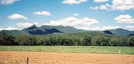 Mount Kaputar, the third peak from the left, is the range's highest peak. | |
| Highest point | |
| Peak | Mount Kaputar |
| Elevation | 1,508 m (4,948 ft) |
| Geography | |
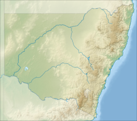 Nandewar Range Location in New South Wales | |
| Country | Australia |
| State | New South Wales |
| Range coordinates | 30°30′S 151°00′E / 30.5°S 151°E |
| Geology | |
| Age of rock | Cenozoic |
| Type of rock | Shield volcano |
John Oxley was the first European to see the range in 1818 as he explored the New South Wales.[1]
Location and features edit
The range is located on the western, inland, side of the New England region, and generally forms the watershed divide between the Namoi River and Gwydir River catchment basins to the south and north respectively.[citation needed] The Macdonald River starting south of Walcha drains west to Warrabah National Park where it changes its name to the Namoi then is added to by the Manilla River, Peel River and Mooki River. The Horton River runs north to the Gwydir. Both rivers together drain segments of the Nandewar Range.[citation needed]
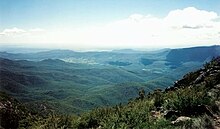
The eastern part of the Nandewar Range starts at the Great Dividing Range south of Uralla. The main road between Narrabri and Bingara crosses the range. At its western end, the Nandewar Range culminates at Mount Kaputar, a complex of volcanic origin, from which there are views of the flat inland plains of New South Wales.
The foothill areas of the Nandewar Range are used for grazing and cropping.[citation needed] There are forests in some of the higher areas. The Mount Kaputar area is included in Mount Kaputar National Park.

The range is occasionally dusted with light snow in winter.[2]
Geology edit
The range is the remnants of an eroded basaltic shield volcano that formed about 18 million years ago. Some of the exposed rocks in the area are 230 million years old.[3]
Etymology edit
The first is a volcanic plug called 'Ninghdoo' (pronounced locally as Ningy-doo) or 'Nungadhun'. The names Nandewar, Kaputar and Ninghdoo are the Gamilaraay language names for these features.
Peaks edit
Mountains within the Nandewar Range include;
- Bushy Mountain, (1,260 m or 4,134 ft)
- Castletop Mountain
- Gins Mountain
- Grattai Mountain, (1,301 m or 4,268 ft)[4]
- Mount Dowe, (1,457 m or 4,780 ft)[5]
- Mount Kaputar, (1,489 m or 4,885 ft)[6]
- Mount Lawler
- Mount Lindesay, (1,373 m or 4,505 ft)
- Mount Ningadhun, (1,013 m or 3,323 ft)[7]
- Mount Waa
- Mount Yulludunida
- Round Mountain
See also edit
References edit
- ^ Oxley, John (2014). "Journal of an Expedition in Australia — Part II". Journals of Two Expeditions into the Interior of New South Wales, by order of the British Government in the years 1817-18. The University of Adelaide. Archived from the original (ebook) on July 15, 2011. Retrieved 27 May 2015.
- ^ a b Hutton, Geoffrey (1981). Australia's Natural Heritage. Australian Conservation Foundation. p. 102. ISBN 0-85802-063-7.
- ^ Mount Kaputar National Park Park Guide (1994). New South Wales National Parks and Wildlife Service.
- ^ "Grattai Mountain - NSW". ExplorOz. I.T. Beyond Pty Ltd. 2015. Retrieved 27 May 2015.
- ^ "Mount Dowe - NSW". ExplorOz. I.T. Beyond Pty Ltd. 2015. Retrieved 27 May 2015.
- ^ "Mount Kaputar - NSW". ExplorOz. I.T. Beyond Pty Ltd. 2015. Retrieved 27 May 2015.
- ^ "Mount Ningadhun - NSW". ExplorOz. I.T. Beyond Pty Ltd. 2015. Retrieved 27 May 2015.