
KNOWPIA
WELCOME TO KNOWPIA

National Register of Historic Places listings in Alleghany County, Virginia 
Summary
This is a list of the National Register of Historic Places listings in Alleghany County, Virginia.

This is intended to be a complete list of the properties and districts on the National Register of Historic Places in Alleghany County, Virginia, United States. The locations of National Register properties and districts for which the latitude and longitude coordinates are included below, may be seen in an online map.[1]
There are 14 properties and districts listed on the National Register in the county, including 1 National Historic Landmark.
This National Park Service list is complete through NPS recent listings posted April 12, 2024.[2]
Current listings edit
| [3] | Name on the Register[4] | Image | Date listed[5] | Location | City or town | Description |
|---|---|---|---|---|---|---|
| 1 | Clifton Forge Commercial Historic District |  |
January 28, 1992 (#91002015) |
Roughly E. Ridgeway St. from Roxbury St. to Main St., and Main from Commercial Ave. to Railroad St.; also 321 Commercial Ave. 37°48′56″N 79°49′34″W / 37.815556°N 79.826111°W | Clifton Forge | 321 Commercial represents a boundary increase approved November 24, 2017 |
| 2 | Clifton Forge Residential Historic District | 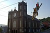 |
August 14, 2012 (#12000517) |
Roughly bounded by Memorial Park, Crown Hill Cemetery, Dry Creek, Keswick, Lowell, Main, and Pine Sts., and McCormick Boulevard 37°49′06″N 79°49′32″W / 37.818333°N 79.825556°W | Clifton Forge | |
| 3 | Clifton Furnace |  |
August 16, 1977 (#77001485) |
Southeast of Clifton Forge off U.S. Route 220 37°48′35″N 79°47′51″W / 37.809861°N 79.797500°W | Clifton Forge | |
| 4 | Douthat State Park Historic District | 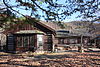 |
September 20, 1986 (#86002183) |
Douthat State Park Rd. 37°52′02″N 79°48′51″W / 37.867222°N 79.814167°W | Millboro | |
| 5 | Humpback Bridge | 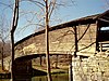 |
October 1, 1969 (#69000219) |
Over Dunlap Creek, south of the junction of U.S. Route 60 and Rumsey Rd. 37°48′02″N 80°02′49″W / 37.800556°N 80.047083°W | Callaghan | National Historic Landmark designation October 16, 2012 |
| 6 | Jefferson School |  |
December 27, 2010 (#10001061) |
A St. 37°48′57″N 79°49′08″W / 37.815972°N 79.818889°W | Clifton Forge | |
| 7 | Longdale Furnace Historic District |  |
August 3, 1995 (#95000898) |
Roughly along Longdale Furnace Rd., Iron Ore Ln., Church Rd., and Conner Lane 37°48′34″N 79°41′05″W / 37.809444°N 79.684722°W | Clifton Forge | |
| 8 | Luke Mountain Historic District |  |
June 26, 1998 (#98000737) |
Luke Mountain Rd. 37°47′36″N 80°00′18″W / 37.793333°N 80.005000°W | Covington | |
| 9 | Massie House |  |
July 8, 1982 (#82004669) |
U.S. Route 220 37°52′40″N 79°55′14″W / 37.877778°N 79.920556°W | Falling Spring | |
| 10 | Oakland Grove Presbyterian Church |  |
July 8, 1982 (#82004670) |
Selma Low Moor Rd. 37°48′07″N 79°51′37″W / 37.801944°N 79.860278°W | Selma | |
| 11 | Persinger House |  |
July 8, 1982 (#82004668) |
Llama Dr. 37°43′05″N 80°03′33″W / 37.718056°N 80.059167°W | Covington | |
| 12 | Rosedale Historic District |  |
June 26, 1998 (#98000738) |
Roughly bounded by U.S. Route 60, the Jackson River, and Luke's Mountain 37°47′42″N 80°00′00″W / 37.795000°N 80.000000°W | Covington | |
| 13 | Sweet Chalybeate Springs |  |
January 21, 1974 (#74002103) |
South of Earlhurst on State Route 311 37°38′40″N 80°14′20″W / 37.644444°N 80.238889°W | Sweet Chalybeate | |
| 14 | Wood Hall | July 26, 1982 (#82004667) |
Indian Draft Rd. 37°48′59″N 80°04′19″W / 37.816250°N 80.071944°W | Callaghan |
See also edit
Wikimedia Commons has media related to National Register of Historic Places in Alleghany County, Virginia.
References edit
- ^ The latitude and longitude information provided in this table was derived originally from the National Register Information System, which has been found to be fairly accurate for about 99% of listings. Some locations in this table may have been corrected to current GPS standards.
- ^ National Park Service, United States Department of the Interior, "National Register of Historic Places: Weekly List Actions", retrieved April 12, 2024.
- ^ Numbers represent an alphabetical ordering by significant words. Various colorings, defined here, differentiate National Historic Landmarks and historic districts from other NRHP buildings, structures, sites or objects.
- ^ "National Register Information System". National Register of Historic Places. National Park Service. April 24, 2008.
- ^ The eight-digit number below each date is the number assigned to each location in the National Register Information System database, which can be viewed by clicking the number.