
KNOWPIA
WELCOME TO KNOWPIA

National Register of Historic Places listings in Arches National Park 
Summary
This is a list of the National Register of Historic Places listings in Arches National Park.
This is intended to be a complete list of the properties and districts on the National Register of Historic Places in Arches National Park, Utah, United States. The locations of National Register properties and districts for which the latitude and longitude coordinates are included below, may be seen in a Google map.[1]
There are six properties and districts listed on the National Register in the park.
This National Park Service list is complete through NPS recent listings posted April 12, 2024.[2]
Current listings edit
| [3] | Name on the Register | Image | Date listed[4] | Location | City or town | Description |
|---|---|---|---|---|---|---|
| 1 | Courthouse Wash Pictographs |  |
April 1, 1976 (#76000207) |
1 mile northwest of Moab in Arches National Park on State Route 163 38°36′26″N 109°34′47″W / 38.607222°N 109.579722°W | Moab | |
| 2 | Julien Inscription Panel | October 6, 1988 (#88001184) |
Dark Angel vicinity 38°49′23″N 109°39′00″W / 38.823056°N 109.65°W | Moab | ||
| 3 | Old Spanish Trail | 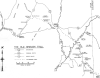 |
October 6, 1988 (#88001181) |
Visitor Center vicinity 38°36′44″N 109°37′14″W / 38.612222°N 109.620556°W | Moab | |
| 4 | Ringhoffer Inscription | October 6, 1988 (#88001185) |
Tower Arch 38°47′25″N 109°41′17″W / 38.790278°N 109.688056°W | Moab | ||
| 5 | Rock House-Custodian's Residence | 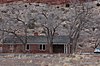 |
October 6, 1988 (#88001186) |
Arches National Park Visitor Center vicinity 38°37′04″N 109°36′55″W / 38.617778°N 109.615278°W | Moab | |
| 6 | Wolfe Ranch Historical District | 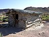 |
November 20, 1975 (#75000167) |
North of Moab in Arches National Park 38°44′15″N 109°31′19″W / 38.7375°N 109.521944°W | Moab |
See also edit
References edit
- Mehls, Steven F. and Mehls, Carol Drake. National Register of Historic Places Registration Form: Arches National Park Multiple Resource. National Park Service February 15, 1988 https://npgallery.nps.gov/NRHP/GetAsset/NRHP/64000857_text
- ^ The latitude and longitude information provided in this table was derived originally from the National Register Information System, which has been found to be fairly accurate for about 99% of listings. Some locations in this table may have been corrected to current GPS standards.
- ^ National Park Service, United States Department of the Interior, "National Register of Historic Places: Weekly List Actions", retrieved April 12, 2024.
- ^ Numbers represent an alphabetical ordering by significant words. Various colorings, defined here, differentiate National Historic Landmarks and historic districts from other NRHP buildings, structures, sites or objects.
- ^ The eight-digit number below each date is the number assigned to each location in the National Register Information System database, which can be viewed by clicking the number.
Wikimedia Commons has media related to National Register of Historic Places in Arches National Park.