
KNOWPIA
WELCOME TO KNOWPIA

National Register of Historic Places listings in Calhoun County, South Carolina 
Summary
This is a list of the National Register of Historic Places listings in Calhoun County, South Carolina.

This is intended to be a complete list of the properties on the National Register of Historic Places in Calhoun County, South Carolina, United States. The locations of National Register properties for which the latitude and longitude coordinates are included below, may be seen in a map.[1]
There are 18 properties listed on the National Register in the county.
This National Park Service list is complete through NPS recent listings posted April 12, 2024.[2]
Current listings edit
| [3] | Name on the Register[4] | Image | Date listed[5] | Location | City or town | Description |
|---|---|---|---|---|---|---|
| 1 | William Baker House |  |
March 8, 1978 (#78002494) |
East of Gaston off U.S. Route 21 33°49′50″N 80°59′46″W / 33.830556°N 80.996111°W | Gaston | |
| 2 | Col. J.A. Banks House |  |
November 24, 1980 (#80003655) |
104 Dantzler St. 33°39′45″N 80°46′42″W / 33.6625°N 80.778333°W | St. Matthews | |
| 3 | Buyck's Bluff Archeological Site | May 4, 1979 (#79002376) |
Address Restricted | St. Matthews | ||
| 4 | Calhoun County Courthouse | 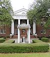 |
October 30, 1981 (#81000561) |
S. Railroad Ave. 33°39′47″N 80°46′46″W / 33.663056°N 80.779444°W | St. Matthews | |
| 5 | Calhoun County Library | 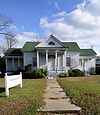 |
May 29, 1975 (#75001690) |
Railroad Ave. 33°40′01″N 80°46′28″W / 33.666944°N 80.774444°W | St. Matthews | |
| 6 | Cherokee Path, Sterling Land Grant | May 13, 1976 (#76001696) |
5 miles southeast of St. Matthews on South Carolina Highway 6 33°38′11″N 80°42′28″W / 33.636389°N 80.707778°W | St. Matthews | ||
| 7 | Culclasure-Geiger Farmstead | May 26, 2023 (#100008999) |
1250 Great Circle Dr. 33°44′56″N 80°53′03″W / 33.7489°N 80.8842°W | St. Matthews vicinity | ||
| 8 | Col. Olin M. Dantzler House |  |
March 30, 1973 (#73001680) |
412 E. Bridge St. 33°39′42″N 80°46′26″W / 33.6616°N 80.7740°W | St. Matthews | |
| 9 | Fort Motte Battle Site | November 9, 1972 (#72001195) |
Address Restricted | Fort Motte | ||
| 10 | Haigler House | 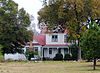 |
October 12, 2001 (#01001099) |
Winding Brook Dr. 33°33′45″N 80°40′52″W / 33.562454°N 80.6812°W | Cameron | |
| 11 | David Houser House |  |
November 25, 1980 (#80003656) |
West of St. Matthews on U.S. Route 176 33°40′37″N 80°50′08″W / 33.676944°N 80.835556°W | St. Matthews | |
| 12 | Lang Syne Plantation | July 18, 2014 (#14000429) |
Address Restricted | St. Matthews vicinity | ||
| 13 | Midway Plantation | 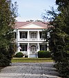 |
May 28, 1976 (#76001694) |
South of Fort Motte off U.S. Route 601 33°40′31″N 80°41′39″W / 33.675278°N 80.694167°W | Fort Motte | |
| 14 | Oakland Plantation |  |
May 30, 1975 (#75001689) |
South of Fort Motte 33°41′12″N 80°40′00″W / 33.686667°N 80.666667°W | Fort Motte | |
| 15 | Prehistoric Indian Village |  |
July 30, 1974 (#74001828) |
Address Restricted | St. Matthews | |
| 16 | Puritan Farm |  |
July 25, 1974 (#74001829) |
West of St. Matthews 33°39′48″N 80°48′56″W / 33.663333°N 80.815556°W | St. Matthews | |
| 17 | Ulmer-Summers House |  |
October 25, 1973 (#73001679) |
Old Orangeburg Rd. (South Carolina Highway 31) 33°33′44″N 80°42′55″W / 33.562222°N 80.715278°W | Cameron | |
| 18 | Zante Plantation |  |
June 29, 1976 (#76001695) |
Southeast of Fort Motte off South Carolina Highway 601 33°42′37″N 80°38′32″W / 33.710278°N 80.642222°W | Fort Motte |
See also edit
Wikimedia Commons has media related to National Register of Historic Places in Calhoun County, South Carolina.
References edit
- ^ The latitude and longitude information provided in this table was derived originally from the National Register Information System, which has been found to be fairly accurate for about 99% of listings. Some locations in this table may have been corrected to current GPS standards.
- ^ National Park Service, United States Department of the Interior, "National Register of Historic Places: Weekly List Actions", retrieved April 12, 2024.
- ^ Numbers represent an alphabetical ordering by significant words. Various colorings, defined here, differentiate National Historic Landmarks and historic districts from other NRHP buildings, structures, sites or objects.
- ^ "National Register Information System". National Register of Historic Places. National Park Service. March 13, 2009.
- ^ The eight-digit number below each date is the number assigned to each location in the National Register Information System database, which can be viewed by clicking the number.