


Summary
This is a list of the National Register of Historic Places listings in Cleveland, Ohio.

This is intended to be a complete list of the properties and districts on the National Register of Historic Places in Cleveland, Ohio, United States. Latitude and longitude coordinates are provided for many National Register properties and districts; these locations may be seen together in an online map.[1]
There are 432 properties and districts listed on the National Register in Cuyahoga County, including 4 National Historic Landmarks. The city of Cleveland is the location of 274 of these properties and districts, including 3 of the National Historic Landmarks; they are listed here, while the remainder are listed separately. Four properties and districts are split between Cleveland and other parts of the county, and are thus included on both lists. Another 8 properties in Cleveland were once listed but have been removed.
This National Park Service list is complete through NPS recent listings posted April 12, 2024.[2]
Current listings edit
| [3] | Name on the Register[4] | Image | Date listed[5] | Location | Description |
|---|---|---|---|---|---|
| 1 | Adelbert Hall |  |
October 30, 1973 (#73001405) |
Case Western Reserve University campus 41°30′18″N 81°36′30″W / 41.505°N 81.608333°W |
A Case Western Reserve University administration building built in 1881 to serve as the home of Western Reserve College. Designed by local architect Joseph Ireland in the Italianate, Romanesque, and Stick-Eastlake styles, it was named after Adelbert Stone, the drowned son of industrialist Amasa Stone. The building was gutted by a fire in June 1991, and restored in 1993.[6] |
| 2 | Allen Memorial Medical Library |  |
November 30, 1982 (#82001365) |
11000 Euclid Ave. 41°30′22″N 81°36′31″W / 41.506111°N 81.608611°W |
A Case Western Reserve University building on Euclid Avenue, designed in the Neoclassical Revival style by the Cleveland firm of Walker and Weeks and completed in 1926.[7][4] |
| 3 | Alta Public Library |  |
October 4, 2005 (#05001143) |
12510 Mayfield Rd. 41°30′29″N 81°35′46″W / 41.508056°N 81.596111°W |
This 1914 Neoclassical addition to Alta House (completed in 1899) was designed by George B. Post of New York City. Alta House burned in 1980 and was demolished in 1981, but the library survived undamaged. A new, smaller Alta House was finished in 1982, and the library underwent a major renovation in 2016. |
| 4 | Ansel Road Apartment Buildings Historic District |  |
July 2, 2008 (#08000589) |
1588 Ansel Rd to 9501 Wade Park Ave. 41°30′53″N 81°37′12″W / 41.514614°N 81.619961°W |
Four apartment buildings (six structures) on Ansel Road between Talbot and Wade Park Avenue, and one apartment building (two structures) on Wade Park Avenue, built overlooking Rockefeller Park between 1910 and 1928. Large and small buildings, for the wealthy and the working class, in a wide range of architectural styles are outstanding examples of early 20th century apartment living. |
| 5 | Archwood Avenue Historic District |  |
March 19, 1987 (#87000428) |
Archwood Ave. roughly bounded by W. 31st Pl. and W. 37th St. 41°27′10″N 81°42′25″W / 41.452778°N 81.706944°W |
|
| 6 | Archwood Congregational Church |  |
May 13, 1994 (#94000416) |
2800 Archwood Ave. 41°27′11″N 81°42′11″W / 41.453056°N 81.703056°W |
|
| 7 | Arnold Wooden Ware Co.-Arnold Wholesale Corp. Building | April 1, 2024 (#100009173) |
5207 Detroit Ave. 41°29′09″N 81°43′22″W / 41.4859°N 81.7229°W |
||
| 8 | The Astrup Company Building |  |
August 31, 2018 (#100002875) |
2937 W. 25th St. 41°28′44″N 81°41′59″W / 41.4789°N 81.6998°W |
|
| 9 | Audubon School | July 18, 2022 (#100007904) |
3055 Martin Luther King Jr. Dr. 41°28′31″N 81°36′35″W / 41.4754°N 81.6096°W |
||
| 10 | Baker Motor Vehicle Company Building |  |
February 21, 2007 (#07000071) |
7100-7122 Euclid Ave. 41°30′14″N 81°38′21″W / 41.503889°N 81.639167°W |
1910 electric automobile luxury showroom, garage, and repair facility designed by local architect Frank B. Meade and erected by the Baker Electric Motor Vehicle Company. A mix of Early Commercial and Mission Revival architecture, it was restored in 2008 and is now a startup business incubator. |
| 11 | Beehive School |  |
April 5, 1984 (#84002910) |
4345 Lee Rd. 41°26′06″N 81°33′53″W / 41.435081°N 81.564750°W |
Demolished about 2009.[8] |
| 12 | Dr. James Bell House |  |
October 16, 1986 (#86002878) |
1822 E. 89th St. 41°30′28″N 81°37′30″W / 41.507687°N 81.624947°W |
A 1901 Richardsonian Romanesque home in the Hough neighborhood designed by local architect George J. Hardway. It epitomizes the local reaction against the excesses of Victorian architecture. |
| 13 | Sarah Benedict House | 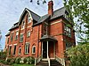 |
November 1, 1984 (#84000220) |
3751 Prospect Ave. 41°30′08″N 81°39′41″W / 41.502222°N 81.661389°W |
|
| 14 | Bingham Company Warehouse | 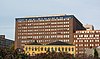 |
November 2, 1973 (#73001406) |
1278 W. 9th St. 41°29′56″N 81°42′05″W / 41.498889°N 81.701389°W |
Designed by Walker and Weeks and completed in 1916, this was formerly the largest single-unit warehouse in the world. It is an exemplar of the Commercial style of architecture. It was converted into The Bingham apartments in 2001. |
| 15 | H. Black and Company Building | 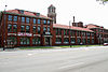 |
January 24, 2002 (#01001523) |
1900 Superior Avenue 41°30′24″N 81°40′45″W / 41.506667°N 81.679167°W |
Clothing manufacturing factory constructed in 1907 and designed by New York City architect Robert D. Kohn, this Mission Revival building was once a nationally-known model for beauty and worker comfort. It is now known as the Tower Press Building. It underwent a renovation in 2003. |
| 16 | Body Block |  |
September 18, 1998 (#98001178) |
4925-4955 Payne Ave., 1692-1696 E. 55th St. 41°30′46″N 81°39′09″W / 41.512778°N 81.652500°W |
Likely designed by local architect George Smith, this Queen Anne style block of apartments has an interior arcade and ground-floor retail. It anchored a major intersection in Goodrich–Kirtland Park for half a century. The structure underwent historic preservation and renovation from 1994 to 1995. |
| 17 | Bohemian National Hall |  |
May 28, 1975 (#75001359) |
4939 Broadway St. 41°28′20″N 81°39′23″W / 41.472222°N 81.656389°W |
Erected by 40 Czech cultural societies in 1896, this building, a mix of Renaissance Revival and Romanesque Revival architecture designed by the local firm of Steffens & Searles, was designed to serve the cultural, political, and social needs of Cleveland's Czech community. (At the time, Cleveland had the fourth-largest Czech population of any city in the world, behind Prague, Vienna, and Chicago). |
| 18 | Bomante House |  |
March 19, 1987 (#87000441) |
3000 Mapledale Ave. 41°27′17″N 81°42′09″W / 41.454722°N 81.702500°W |
This 1905 Swiss Chalet Revival style house was built for Frederick W. Bomonti, a famous Swiss American restaurateur in Cleveland. It is an exemplar of the type of architecture favored by Swiss Americans, a large and influential immigrant group in Cleveland in the late 1800s. |
| 19 | Broadway Avenue Historic District |  |
October 19, 1988 (#88001860) |
Broadway Ave. and E. 55th St. 41°28′02″N 81°39′05″W / 41.467222°N 81.651389°W |
Historic district of 43 buildings constructed between 1888 and 1930. The district runs on Broadway between Cable and Barkwill Avenues, and on E. 55th Street between Lufkin and Broadway Avenues, with a few buildings to either side. It is the heart of the Czech community in Cleveland, and was once the second largest shopping district in the city. |
| 20 | Brooklyn Bank Building |  |
July 19, 1984 (#84002912) |
3764 W. 25th St. 41°27′08″N 81°42′07″W / 41.452222°N 81.701944°W |
1904 bank building in an eclectic mix of styles, designed by noted local architect J. Milton Dyer during his most prolific, creative period. It is a contributing property to the Archwood Avenue Historic District and to the Brooklyn Centre Historic District, and is listed on the NRHP independently as well. |
| 21 | Brooklyn Centre Historic District |  |
March 4, 1999 (#99000238) |
Roughly bounded by Interstate 71, Pearl Rd., and Big Creek Valley 41°27′05″N 81°42′31″W / 41.451389°N 81.708611°W |
|
| 22 | Brownell School and Annex |  |
February 1, 2006 (#05001576) |
1300-1360 Sumner St. 41°29′52″N 81°40′49″W / 41.497778°N 81.680278°W |
Three brick public school buildings in the Queen Anne style, completed in 1885 (John Eisenmann), 1905 (Frank Seymour Barnum), and 1909 (Barnum). Several nationally and locally famous individuals were educated there, and it was the first home of Tri-C. The complex was sold to private investors in 1979, and underwent a significant interior remodel into office space from 1983 to 1985. |
| 23 | Bruce-Macbeth Engine Company |  |
February 14, 2018 (#100002120) |
2111 Center St. 41°29′41″N 81°42′20″W / 41.494813°N 81.705490°W |
|
| 24 | Bryant Building |  |
December 11, 2014 (#14001051) |
1261 Superior Ave. 41°30′15″N 81°41′08″W / 41.504167°N 81.685556°W |
Automobile salesroom and service center built by Mall Motor Co. in 1921 and designed by the local architectural firm of Christian, Schwarzenburg and Gaede. It was sold to Bryant Motor Co. in 1922, from which the building draws its name. The structure was significantly renovated by Masthead Brewing in 2016. |
| 25 | Building at 3101 Euclid Avenue |  |
August 7, 2017 (#100001438) |
3101 Euclid Avenue 41°30′10″N 81°40′00″W / 41.502886°N 81.666538°W |
|
| 26 | Caxton Building |  |
October 30, 1973 (#73001407) |
812 Huron Rd., SE. 41°29′54″N 81°41′10″W / 41.498333°N 81.686111°W |
|
| 27 | Cedar Glen Apartments |  |
June 17, 1994 (#94000594) |
11424-11432 Cedar Glen Parkway 41°29′57″N 81°36′15″W / 41.499167°N 81.604167°W |
A Georgian Revival luxury apartment building completed in 1927 on a bluff overlooking Cedar Glen Parkway. Designed by Samuel H. Weis (a.k.a. Samuel H. White), it was saved from demolition in 1993 and converted to condominiums. |
| 28 | Central YMCA |  |
November 1, 1984 (#84000221) |
2200 Prospect Ave. 41°29′59″N 81°40′26″W / 41.499722°N 81.673889°W |
|
| 29 | Cermak Building |  |
October 18, 1984 (#84000128) |
3503 E. 93rd St. 41°27′48″N 81°37′16″W / 41.463333°N 81.621111°W |
|
| 30 | Cleveland Arcade |  |
March 20, 1973 (#73001408) |
401 Euclid Ave. 41°29′58″N 81°41′36″W / 41.499444°N 81.693333°W |
|
| 31 | Cleveland Centre Historic District | 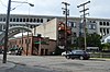 |
January 22, 2014 (#13001117) |
Roughly bounded by James and Riverbed Sts. and the Cuyahoga River 41°29′39″N 81°42′05″W / 41.494167°N 81.701389°W |
|
| 32 | Cleveland Club |  |
February 28, 2008 (#08000113) |
10660 Carnegie Ave. 41°30′02″N 81°36′47″W / 41.500556°N 81.613056°W |
|
| 33 | Cleveland Dental Manufacturing Company Building |  |
September 3, 2004 (#04000936) |
3307 Scranton Rd. 41°27′52″N 81°41′53″W / 41.464444°N 81.698056°W |
|
| 34 | Cleveland Discount Building |  |
October 2, 1991 (#91001416) |
815 Superior Ave., NE. 41°30′10″N 81°41′24″W / 41.502778°N 81.690000°W |
|
| 35 | Cleveland East Pierhead Light |  |
December 19, 1991 (#91001855) |
Eastern breakwater pierhead, entrance to Cleveland harbor 41°30′37″N 81°42′55″W / 41.510278°N 81.715278°W |
|
| 36 | Cleveland Grays Armory | 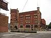 |
March 28, 1973 (#73001409) |
1234 Bolivar Rd. 41°29′56″N 81°40′56″W / 41.498889°N 81.682222°W |
|
| 37 | Cleveland Harbor Station, U.S. Coast Guard |  |
January 1, 1976 (#76001390) |
New West Pier 41°30′11″N 81°42′46″W / 41.503056°N 81.712778°W |
|
| 38 | Cleveland Home for Aged Colored People |  |
December 17, 1982 (#82001366) |
4807 Cedar Ave. 41°30′02″N 81°39′14″W / 41.500556°N 81.653889°W |
|
| 39 | Cleveland Jewish Center-Cory United Methodist Church | April 17, 2023 (#100008829) |
1117 East 105th St. 41°31′35″N 81°36′55″W / 41.5265°N 81.6154°W |
||
| 40 | Cleveland Mall |  |
June 10, 1975 (#75001360) |
Roughly T-shaped mall area between E. 9th and W. 3rd Sts. 41°30′14″N 81°41′36″W / 41.503889°N 81.693333°W |
|
| 41 | Cleveland Masonic Temple |  |
August 17, 2001 (#01000894) |
3615 Euclid Ave. 41°30′13″N 81°39′44″W / 41.503611°N 81.662222°W |
|
| 42 | Cleveland Municipal Stadium | 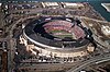 |
November 13, 1987 (#87002287) |
Erieview Dr. 41°30′24″N 81°41′50″W / 41.506667°N 81.697222°W |
Demolished from November 1996 to March 1997[9] |
| 43 | Cleveland Packard Building |  |
November 1, 1984 (#84000222) |
5100-5206 Prospect Ave. 41°30′09″N 81°39′11″W / 41.502500°N 81.653056°W |
|
| 44 | Cleveland Public Carnegie Library Hough Branch |  |
September 6, 2016 (#16000603) |
1765 Crawford Rd. 41°30′32″N 81°37′38″W / 41.508889°N 81.627222°W |
|
| 45 | Cleveland Public Square |  |
December 18, 1975 (#75001361) |
Superior Ave. and Ontario St. 41°29′59″N 81°41′38″W / 41.499722°N 81.693889°W |
|
| 46 | Cleveland State University-University Tower |  |
September 18, 2023 (#100009325) |
1860 East 22nd St. 41°30′12″N 81°40′32″W / 41.5032°N 81.6756°W |
AKA the Rhodes Tower |
| 47 | Cleveland Trust Company | 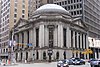 |
November 26, 1973 (#73001410) |
900 Euclid Ave. at E. 9th St. 41°30′00″N 81°41′09″W / 41.500000°N 81.685833°W |
1907 bank building designed by George B. Post featuring a striking glass rotunda, a tympanum sculpture, and interior murals. Interior renovated after 2013 into a grocery store and nightclub. |
| 48 | Cleveland Warehouse District |  |
September 30, 1982 (#82003558) |
Roughly bounded by Front and Superior Aves. and Railroad, Summit, 3rd, and 10th Sts.; also 1384-1410 W. 10th St. 41°30′00″N 81°42′03″W / 41.500000°N 81.700833°W |
10th St. addresses represent a boundary increase of February 21, 2007 |
| 49 | Cleveland West Pierhead Light |  |
August 4, 1983 (#83001950) |
Cleveland Harbor on Lake Erie 41°30′32″N 81°43′04″W / 41.508889°N 81.717778°W |
|
| 50 | Cleveland Worsted Mills Company |  |
August 8, 1985 (#85001695) |
5846-6116 Broadway 41°27′53″N 81°38′57″W / 41.464722°N 81.649167°W |
Destroyed by fire, July 4, 1993[10] |
| 51 | Clinton Apartments |  |
March 29, 2006 (#06000199) |
3607 Clinton Ave. 41°29′13″N 81°42′50″W / 41.486944°N 81.713889°W |
|
| 52 | Colonial and Euclid Arcades | 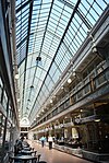 |
May 8, 1987 (#87000660) |
508 and 600 Euclid Ave. 41°29′56″N 81°41′21″W / 41.498889°N 81.689167°W |
|
| 53 | The Commodore Hotel |  |
September 2, 2016 (#16000594) |
11990 Ford Dr.; 11309-11325 Euclid Ave. 41°30′32″N 81°36′21″W / 41.508889°N 81.605833°W |
|
| 54 | Consolidated Fruit Auction Company Building |  |
August 17, 2021 (#100006833) |
601 Stone's Levee 41°29′31″N 81°41′31″W / 41.4920°N 81.6920°W |
|
| 55 | Cook Building |  |
November 1, 1984 (#84000224) |
4600-4800 Prospect Ave. 41°30′08″N 81°39′18″W / 41.502222°N 81.655000°W |
|
| 56 | Corlett Building |  |
October 29, 2003 (#03001101) |
1923-35 Euclid Ave. 41°30′06″N 81°40′39″W / 41.501667°N 81.677500°W |
Demolished[11] |
| 57 | The Courtland |  |
November 2, 2000 (#00001296) |
5403 Detroit Ave. 41°29′07″N 81°43′28″W / 41.485278°N 81.724444°W |
|
| 58 | Justus L. Cozad House |  |
January 18, 1974 (#74001435) |
11508 Mayfield Rd. 41°30′29″N 81°36′11″W / 41.508056°N 81.603056°W |
|
| 59 | Crawford-Tilden Apartments |  |
March 21, 1978 (#78002038) |
1831-1843 Crawford Rd. and 1878-1888 E. 84th St. 41°30′25″N 81°37′45″W / 41.506944°N 81.629167°W |
The structure, built in 1908, is notable partially because of the way it is situated on a triangular piece of land, not unlike the Flatiron Building. |
| 60 | Andrew Dall, Jr., and James Dall Houses |  |
July 19, 1984 (#84002913) |
2225 and 2229 E. 46th St. 41°29′52″N 81°39′14″W / 41.497778°N 81.653889°W |
|
| 61 | Detroit-Superior High Level Bridge |  |
January 18, 1974 (#74001437) |
Over the Cuyahoga River valley between Detroit Ave. and Superior Ave. 41°29′39″N 81°42′09″W / 41.494167°N 81.702500°W |
|
| 62 | Division Avenue Pumping Station |  |
January 18, 1974 (#74001438) |
Division Ave., at the foot of W. 45th St. 41°29′24″N 81°43′00″W / 41.490000°N 81.716667°W |
|
| 63 | Dixon Hall Apartments |  |
November 1, 1984 (#84000225) |
3814 Prospect Ave. 41°30′06″N 81°39′36″W / 41.501667°N 81.660000°W |
|
| 64 | Doan School |  |
August 23, 1984 (#84002915) |
1350 E. 105th St. 41°31′13″N 81°36′58″W / 41.520278°N 81.616111°W |
|
| 65 | Dunham Tavern |  |
July 25, 1974 (#74001439) |
6709 Euclid Ave. 41°30′17″N 81°38′19″W / 41.504722°N 81.638611°W |
|
| 66 | East 89th Street Historic District |  |
May 26, 1988 (#88000678) |
E. 89th St. roughly between Chester and Hough Aves. 41°30′30″N 81°37′31″W / 41.508333°N 81.625278°W |
|
| 67 | East Boulevard Apartment House |  |
August 24, 2017 (#100001506) |
2691 E. 116th St. 41°29′09″N 81°36′09″W / 41.485701°N 81.602623°W |
|
| 68 | East Boulevard Historic District |  |
November 29, 1995 (#95001366) |
Roughly bounded by East Boulevard, St. Clair Ave., E. 99th St. and University Cir. 41°31′27″N 81°37′16″W / 41.524167°N 81.621111°W |
|
| 69 | East Fourth Street Historic District |  |
July 9, 1987 (#87001179) |
Roughly on E. 4th St. between Euclid and Prospect Aves. 41°29′57″N 81°41′24″W / 41.499167°N 81.690000°W |
|
| 70 | The East Ohio Building |  |
January 23, 2013 (#12001212) |
1717 E. 9th St. 41°30′08″N 81°41′17″W / 41.502149°N 81.687945°W |
|
| 71 | East Ohio Gas Company Building |  |
February 20, 2003 (#03000043) |
1403 E. 6th St. 41°30′09″N 81°41′29″W / 41.502500°N 81.691389°W |
|
| 72 | Empire Junior High School | July 7, 2023 (#100009088) |
9113 Parmelee Ave. 41°31′56″N 81°37′26″W / 41.5322°N 81.6238°W |
||
| 73 | Jeremiah Ensworth House |  |
November 1, 1984 (#84000226) |
3214 Prospect Ave. 41°30′04″N 81°39′50″W / 41.501111°N 81.663889°W |
|
| 74 | Erie Railroad Cleveland Powerhouse |  |
July 19, 1984 (#84003614) |
1246 River Rd. 41°29′47″N 81°42′42″W / 41.496389°N 81.711667°W |
Demolished May 2014[12] |
| 75 | Erieview Historic District | February 1, 2021 (#100006084) |
Roughly bounded by Lakeside Ave., Chester Ave., East 9th St., and East 12th St. 41°30′13″N 81°41′18″W / 41.5037°N 81.6883°W |
||
| 76 | Erieview Tower |  |
September 25, 2017 (#100001655) |
1322 E. 12th St. 41°30′19″N 81°41′18″W / 41.505278°N 81.688333°W |
|
| 77 | Euclid Avenue Christian Church |  |
February 10, 2022 (#100007415) |
9990 Euclid Ave. 41°30′12″N 81°37′09″W / 41.5034°N 81.6192°W |
1908 Romanesque Revival church built by Disciples of Christ. Sold to East Mt. Zion Baptist Church in 1955. |
| 78 | Euclid Avenue Historic District |  |
June 28, 2002 (#02000702) |
Roughly bounded by Public Square, Euclid Ave. to E. 17th St., and E. 21st St.; also 205 St. Clair Ave., 1370 Ontario St., and 1796-1808 E. 13th St.; also 1835 to 1937 Prospect Ave. East 41°30′02″N 81°41′12″W / 41.500556°N 81.686667°W |
Second set of addresses represents a boundary increase of May 29, 2007; third set represents a boundary increase approved June 24, 2022. |
| 79 | Euclid Avenue Presbyterian Church |  |
March 12, 1980 (#80002977) |
11205 Euclid Ave. 41°30′30″N 81°36′27″W / 41.508333°N 81.6075°W |
|
| 80 | Euclid Avenue Temple-Liberty Hill Baptist Church | January 11, 2024 (#100009713) |
8206 Euclid Avenue 41°30′13″N 81°37′51″W / 41.5035°N 81.6307°W |
||
| 81 | The Euclid-Seventy-First Street Building |  |
August 8, 1996 (#96000866) |
7002-7030 Euclid Ave. 41°30′15″N 81°38′25″W / 41.504167°N 81.640278°W |
|
| 82 | Fairhill Road Village Historic District |  |
May 10, 1990 (#90000758) |
12309-12511 Fairhill Rd. 41°29′36″N 81°35′47″W / 41.493333°N 81.596389°W |
Extends into Cleveland Heights, elsewhere in Cuyahoga County[13] |
| 83 | Fairmont Creamery Company Ice Cream Building | 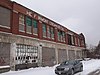 |
February 23, 2015 (#15000038) |
1720 Willey Ave. and 2306 W. 17th St. 41°28′50″N 81°41′45″W / 41.480556°N 81.695833°W |
|
| 84 | Federal Knitting Mills Building |  |
January 16, 2001 (#00001662) |
2860-2894 Detroit Ave.; also 2820 and 2811-21 Vermont Ave. 41°29′20″N 81°42′49″W / 41.488889°N 81.713611°W |
Vermont Ave. addresses represent a boundary increase of February 1, 2006 |
| 85 | Federal Reserve Bank of Cleveland | 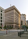 |
October 8, 1976 (#76001392) |
E. 6th St. and Superior Ave. 41°30′06″N 81°41′26″W / 41.501667°N 81.690556°W |
|
| 86 | Fenway Hall | 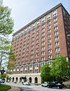 |
December 13, 2016 (#16000845) |
1986 Stokes Boulevard 41°30′14″N 81°36′48″W / 41.503889°N 81.613333°W |
13-story Georgian Revival residential hotel completed in 1923. It is the last surviving building of the Doan's Corners commercial and entertainment district. |
| 87 | First Church of Christ, Scientist |  |
February 20, 2003 (#03000042) |
2200 Overlook Rd. 41°30′12″N 81°35′58″W / 41.503333°N 81.599444°W |
|
| 88 | First Methodist Church | 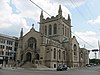 |
September 1, 1995 (#84003953) |
3000 Euclid Ave. 41°30′08″N 81°40′01″W / 41.502222°N 81.666944°W |
|
| 89 | Ford Motor Company Cleveland Plant |  |
March 17, 1976 (#76001393) |
11610 Euclid Ave. 41°30′38″N 81°36′10″W / 41.510556°N 81.602778°W |
|
| 90 | Forest City Bank Building |  |
August 31, 1992 (#86003827) |
1400 W. 25th St. 41°29′28″N 81°42′27″W / 41.491111°N 81.707500°W |
|
| 91 | Forest City Brewery |  |
May 3, 1976 (#76001394) |
6920-6922 Union Ave. 41°27′47″N 81°38′24″W / 41.463056°N 81.640000°W |
|
| 92 | Franklin Boulevard Historic District |  |
May 31, 1989 (#89000430) |
Franklin Boulevard from W. 52nd to W. 38th Sts. 41°29′08″N 81°42′56″W / 41.485556°N 81.715556°W |
|
| 93 | Franklin Boulevard-West Clinton Avenue Historic District |  |
December 6, 1993 (#93001334) |
5207-7625 Franklin Boulevard and 5802-7325 W. Clinton Ave.; also 6801-7003 and 7319-7405 Detroit Ave. 41°28′55″N 81°43′46″W / 41.481944°N 81.729444°W |
Detroit Avenue represents a boundary increase of December 5, 2006 |
| 94 | Phillip Gaensslen House |  |
November 1, 1984 (#84000227) |
3050 Prospect Ave. 41°30′03″N 81°39′58″W / 41.500833°N 81.666111°W |
|
| 95 | Garfield Memorial |  |
April 11, 1973 (#73001411) |
12316 Euclid Ave. in Lake View Cemetery 41°30′36″N 81°35′29″W / 41.51°N 81.591389°W |
Extends into Cleveland Heights, elsewhere in Cuyahoga County[14] |
| 96 | Dr. William Gifford House |  |
November 1, 1984 (#84000228) |
3047 Prospect Ave. 41°30′05″N 81°39′58″W / 41.501389°N 81.666111°W |
|
| 97 | Francis K. Glidden House |  |
February 8, 1988 (#88000054) |
1901 Ford Dr. 41°30′40″N 81°36′30″W / 41.511111°N 81.608333°W |
|
| 98 | Globe Iron Works Building |  |
March 17, 1994 (#94000245) |
2320 Center St. 41°29′45″N 81°42′32″W / 41.495833°N 81.708889°W |
|
| 99 | Globe Machine and Stamping Company |  |
January 14, 2013 (#12001180) |
1250 W. 76th St. 41°29′11″N 81°44′17″W / 41.48627°N 81.738047°W |
|
| 100 | Jacob Goldsmith House |  |
March 8, 1978 (#78002039) |
2200 E. 40th St. 41°29′53″N 81°39′26″W / 41.498056°N 81.657222°W |
Demolished in January 1989 after arson two months prior[15] |
| 101 | Gordon Square Building |  |
April 30, 1985 (#85000944) |
6500-6616 Detroit Ave. and 1396-1490 W. 65th St. 41°29′03″N 81°43′51″W / 41.484167°N 81.730833°W |
|
| 102 | Gordon Square Historic District |  |
October 25, 2002 (#02001209) |
Detroit Ave. and W. 65th St. 41°29′02″N 81°43′50″W / 41.483889°N 81.730556°W |
|
| 103 | Greyhound Bus Station |  |
June 2, 1999 (#91000302) |
1465 Chester Ave. 41°30′12″N 81°40′56″W / 41.503333°N 81.682222°W |
|
| 104 | Grossman Paper Box Company |  |
August 15, 2016 (#16000601) |
1729 Superior Ave. 41°30′23″N 81°40′52″W / 41.506389°N 81.681111°W |
|
| 105 | Halle Building | 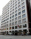 |
September 8, 1983 (#83001953) |
1228 Euclid Ave. 41°30′00″N 81°40′59″W / 41.500000°N 81.683056°W |
|
| 106 | Halle's Shaker Square |  |
February 9, 2005 (#05000029) |
13000 Shaker Boulevard 41°29′00″N 81°35′32″W / 41.483333°N 81.592222°W |
|
| 107 | Harp Apartments | 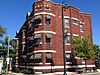 |
March 9, 2000 (#00000180) |
1389 W. 64th St. 41°29′05″N 81°43′45″W / 41.484722°N 81.729167°W |
|
| 108 | Harvard School |  |
May 22, 2002 (#02000550) |
6900 Harvard Ave. 41°26′54″N 81°38′28″W / 41.448333°N 81.641111°W |
|
| 109 | Nathaniel Hawthorne Elementary School | July 11, 2022 (#100007884) |
3575 West 130th St. 41°27′25″N 81°46′46″W / 41.4569°N 81.7794°W |
||
| 110 | Hay-McKinney and Bingham-Hanna House |  |
June 18, 1976 (#76001395) |
10825 E. Boulevard 41°30′48″N 81°36′38″W / 41.513333°N 81.610556°W |
|
| 111 | Herold Building |  |
January 29, 2013 (#12001245) |
310 Prospect Ave. 41°29′53″N 81°41′25″W / 41.498019°N 81.69022°W |
|
| 112 | Hessler Court Wooden Pavement |  |
March 3, 1975 (#75001362) |
11330 East Boulevard between Bellflower and Hessler Rds. 41°30′39″N 81°36′20″W / 41.510833°N 81.605556°W |
|
| 113 | James Hill House |  |
May 13, 1994 (#94000415) |
1840 W. 58th St. 41°28′54″N 81°43′36″W / 41.481667°N 81.726667°W |
|
| 114 | Hilliard Apartment Building |  |
March 17, 1987 (#86003502) |
2804-2906 Sackett Ave. 41°27′49″N 81°42′06″W / 41.463611°N 81.701667°W |
|
| 115 | Holy Rosary Church |  |
June 16, 1976 (#76001397) |
12021 Mayfield Rd. 41°30′32″N 81°35′56″W / 41.508889°N 81.598889°W |
|
| 116 | Hotel Statler | 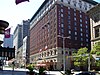 |
April 1, 1998 (#98000317) |
1127 Euclid Ave. 41°30′02″N 81°41′06″W / 41.500556°N 81.685°W |
|
| 117 | House of Wills |  |
December 17, 1982 (#82001367) |
2491 E. 55th St. 41°29′26″N 81°39′06″W / 41.490556°N 81.651667°W |
|
| 118 | Hoyt Block |  |
January 18, 1974 (#74001440) |
608 W. St. Clair St. 41°29′59″N 81°41′56″W / 41.499722°N 81.698889°W |
|
| 119 | Hruby Conservatory of Music |  |
November 29, 1979 (#79001807) |
5417 Broadway St. 41°28′05″N 81°39′07″W / 41.468056°N 81.651944°W |
|
| 120 | Hubbard Cooke Block | 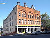 |
December 22, 2014 (#14001073) |
2206-2220 Superior Viaduct 41°29′36″N 81°42′22″W / 41.493333°N 81.706111°W |
|
| 121 | Joseph Ireland House | 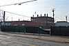 |
November 1, 1984 (#84000229) |
2074 E. 36th St. 41°30′03″N 81°39′46″W / 41.500833°N 81.662778°W |
Demolished[16] |
| 122 | Irishtown Bend Archeological District | 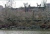 |
May 25, 1990 (#90000757) |
Western bank of the Cuyahoga River, along Riverbed Rd.[17] 41°29′22″N 81°42′18″W / 41.489573°N 81.704895°W |
|
| 123 | Jennings Apartments |  |
March 29, 1984 (#84003618) |
2711 W. 14th St. 41°28′30″N 81°41′29″W / 41.475°N 81.691389°W |
|
| 124 | Jones Home for Children |  |
August 30, 1996 (#87002636) |
3518 W. 25th St. 41°27′30″N 81°42′06″W / 41.458333°N 81.701667°W |
|
| 125 | Jones Home Subdivisions Historic District |  |
February 17, 2012 (#12000031) |
Woodbridge, Marvin, Daisy, and Library Aves., and W. 25th St. 41°27′34″N 81°42′20″W / 41.459444°N 81.705556°W |
|
| 126 | The Joseph and Feiss Clothcraft Shops |  |
October 28, 2010 (#10000873) |
2149 W. 53rd St. 41°28′23″N 81°43′14″W / 41.473056°N 81.720556°W |
|
| 127 | Karamu House |  |
December 17, 1982 (#82001368) |
2355 E. 89th St. 41°29′37″N 81°37′26″W / 41.493611°N 81.623889°W |
|
| 128 | Kendel Building |  |
January 29, 2013 (#12001246) |
210 Prospect Ave. 41°29′53″N 81°41′26″W / 41.497955°N 81.69052°W |
|
| 129 | Kennedy Apartments and Commercial Block |  |
July 6, 1989 (#85003764) |
6425 Detroit Ave. 41°29′02″N 81°43′48″W / 41.483889°N 81.730000°W |
|
| 130 | Lewis Kies House |  |
August 11, 2004 (#04000833) |
4208 Prospect Ave. 41°30′08″N 81°39′25″W / 41.502222°N 81.656944°W |
|
| 131 | W.H. Kindra Apartments | 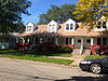 |
March 19, 1987 (#87000434) |
3802-2812 Mapledale Ave. 41°27′16″N 81°42′37″W / 41.454583°N 81.710278°W |
|
| 132 | Krause Building-Otto Moser's Cafe |  |
November 14, 1985 (#85002834) |
2042-2044 E. 4th St. 41°29′56″N 81°41′27″W / 41.498889°N 81.690833°W |
|
| 133 | Theodor Kundtz Company Building |  |
February 2, 2001 (#01000051) |
2249 Elm St. 41°29′44″N 81°42′22″W / 41.495556°N 81.706111°W |
|
| 134 | Lake Shore Bank and Cleveland Public Library St. Clair Branch |  |
December 15, 2015 (#15000901) |
5410 St. Clair Ave. and 1368 E. 55th St. 41°31′19″N 81°39′08″W / 41.521944°N 81.652222°W |
|
| 135 | LaSalle Theatre Building |  |
June 15, 2011 (#11000365) |
819-829 E. 185th St. 41°35′06″N 81°32′59″W / 41.585°N 81.549722°W |
|
| 136 | League Park |  |
August 8, 1979 (#79001808) |
Lexington and 66th Sts. 41°30′42″N 81°38′39″W / 41.511667°N 81.644167°W |
|
| 137 | Lerner Building |  |
June 24, 2000 (#00000750) |
322-324 Euclid Ave. 41°30′02″N 81°41′31″W / 41.500556°N 81.691944°W |
|
| 138 | Lindner Building |  |
September 13, 1978 (#78002040) |
1331 Euclid Ave. 41°30′04″N 81°40′55″W / 41.501111°N 81.681944°W |
|
| 139 | Lion Knitting Mills |  |
September 12, 2016 (#16000617) |
3256 W. 25th St. 41°27′57″N 81°42′02″W / 41.465833°N 81.700556°W |
|
| 140 | Liquid Carbonic Corporation Dry Ice Plant |  |
December 22, 2014 (#14001074) |
1318 W. 58th St. 41°29′15″N 81°43′36″W / 41.487500°N 81.726667°W |
|
| 141 | Henry W. Longfellow School | February 20, 2020 (#100004982) |
650 East 140th St. 41°33′48″N 81°35′07″W / 41.5633°N 81.5854°W |
||
| 142 | Lorain Avenue Commercial Historic District |  |
June 17, 1994 (#94000596) |
3202-5730 Lorain Ave. 41°28′50″N 81°42′47″W / 41.480556°N 81.713056°W |
|
| 143 | Lorain Station Historic District |  |
May 13, 1994 (#94000417) |
9005-10134 Lorain Ave. 41°28′05″N 81°44′57″W / 41.468056°N 81.749167°W |
|
| 144 | Lorain-Carnegie Bridge |  |
October 8, 1976 (#76001398) |
Spans the Cuyahoga River between Lorain and Carnegie Aves. 41°29′26″N 81°41′30″W / 41.490556°N 81.691667°W |
|
| 145 | Lower Prospect-Huron Historic District |  |
November 19, 1995 (#94000640) |
Seven blocks in downtown centered around the junction of Prospect Ave., Huron Rd. and E. 9th St.; also 727, 737, 1020-1060, and 1124 Bolivar Rd., 2217 E. 9th St., and 1303 Prospect Ave. 41°29′55″N 81°41′10″W / 41.498611°N 81.686111°W |
Second set of addresses represents a boundary increase of June 10, 2005 |
| 146 | Magnolia-Wade Park Historic District | 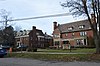 |
October 25, 1990 (#90001566) |
Roughly bounded by Asbury Ave., E. 118th St., Wade Park Ave., Mistletoe Dr., Magnolia Dr., and E. 105th St. 41°30′54″N 81°36′30″W / 41.515°N 81.608333°W |
|
| 147 | Mallo House | 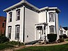 |
March 19, 1987 (#87000439) |
3781 W. 25th St. 41°27′12″N 81°42′04″W / 41.453333°N 81.701111°W |
|
| 148 | Flora Stone Mather College District |  |
February 15, 1974 (#74001442) |
Bellflower Rd. at Ford Dr. 41°30′32″N 81°36′28″W / 41.508889°N 81.607778°W |
|
| 149 | May Company |  |
January 18, 1974 (#74001443) |
158 Euclid Ave. at Public Sq. 41°29′55″N 81°41′31″W / 41.498611°N 81.691944°W |
|
| 150 | The Mayfield Theatre Building | 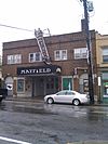 |
June 14, 2013 (#13000389) |
12300 Mayfield Road 41°30′30″N 81°35′50″W / 41.508421°N 81.597347°W |
|
| 151 | McKinley Terrace |  |
July 9, 1985 (#85001527) |
1406-1426 W. 81st St. 41°28′51″N 81°44′29″W / 41.480833°N 81.741389°W |
|
| 152 | McKinley School | July 18, 2022 (#100007907) |
3349 W. 125th St. 41°27′42″N 81°46′30″W / 41.4616°N 81.7751°W |
||
| 153 | Medical Centre Building |  |
December 20, 1984 (#84000621) |
1001 Huron Rd. 41°30′00″N 81°41′06″W / 41.500000°N 81.685000°W |
|
| 154 | George Merwin House |  |
June 4, 1973 (#73001412) |
3028 Prospect Ave. 41°30′06″N 81°39′52″W / 41.501667°N 81.664444°W |
"George Buckingham Merwin ... built a fine brick-house at the head of Prospect Street, which was then west of Sterling, now East 30th Street. When Prospect Street was cut through Sterling, this home was moved to the south side of it. It is a fine type of the architecture of that day, and the high ceilings of its interior, the size of the rooms, and the fine finish of all woodwork evidence refined and dignified taste. It is at present the home of the Rowfant Club, a very appropriate one for book-lovers, as George Merwin was a student all his life."[18][19] |
| 155 | Midtown Historic District | February 22, 2021 (#100006160) |
Perkins (south side), Chester, Euclid, Prospect, and Carnegie (north side) Aves., roughly between I-90, East 27th, East 40th and East 55th Sts. 41°30′13″N 81°39′46″W / 41.5035°N 81.6627°W |
||
| 156 | Miles Park Historic District | 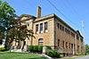 |
May 17, 1974 (#74001444) |
Miles Park Avenue between E. 91st and E. 93rd Streets 41°26′49″N 81°37′21″W / 41.446944°N 81.622500°W |
|
| 157 | Miller Block |  |
July 19, 1984 (#84003624) |
3202-3214 Lorain Ave. 41°28′55″N 81°42′33″W / 41.481944°N 81.709167°W |
|
| 158 | Monmouth Building |  |
June 27, 2022 (#100007831) |
11619 Euclid Ave. 41°30′40″N 81°36′10″W / 41.5110°N 81.6028°W |
|
| 159 | Montana Apartments |  |
November 1, 1984 (#84000230) |
2061 E. 36th St. 41°30′04″N 81°39′45″W / 41.501194°N 81.662500°W |
Demolished prior to 2005[20] |
| 160 | Moreland Theater Building |  |
September 15, 2011 (#11000670) |
11810-11824 Buckeye Rd. 41°28′50″N 81°36′01″W / 41.480556°N 81.600278°W |
1927 building by Braverman and Havermaet that served multiple uses in Cleveland's Hungarian community[21] |
| 161 | Garrett Morgan House |  |
December 17, 1982 (#82001369) |
5202 Harlem Ave. 41°30′53″N 81°39′12″W / 41.514722°N 81.653333°W |
Demolished[22] |
| 162 | Mount Auburn School | June 6, 2022 (#100007757) |
10110 Mount Auburn Ave. 41°28′34″N 81°36′52″W / 41.4762°N 81.6145°W |
||
| 163 | Mueller Electric Company Building |  |
February 23, 2016 (#16000042) |
1587 E. 31st St. 41°30′32″N 81°40′04″W / 41.508952°N 81.667842°W |
|
| 164 | Murray Hill School |  |
April 28, 1988 (#88000436) |
2026 Murray Hill Rd. and 2043 Random Rd. 41°30′27″N 81°35′55″W / 41.507500°N 81.598611°W |
|
| 165 | Myrtle-Highview Historic District | December 23, 2019 (#100004778) |
16209 to 16408 Highview Dr. & 16200 to 16409 Myrtle Ave; Roughly bounded by Lee Rd, Myrtle Ave., Highview Dr. & dead end. 41°25′38″N 81°33′59″W / 41.4272°N 81.5663°W |
||
| 166 | National Town and Country Club |  |
October 30, 2003 (#03001102) |
2401 Euclid Ave. 41°30′08″N 81°40′20″W / 41.502222°N 81.672222°W |
|
| 167 | Neal Terrace |  |
October 3, 2012 (#12000834) |
8811 Detroit Ave. 41°28′46″N 81°44′42″W / 41.479444°N 81.745000°W |
|
| 168 | Neff Apartments |  |
November 1, 1984 (#84000231) |
3606 Prospect Ave. 41°30′05″N 81°39′45″W / 41.501389°N 81.662500°W |
Demolished prior to 2005; the photo is of the structure that replaced that building[23][24] |
| 169 | New England Building |  |
September 8, 2000 (#00001065) |
617-637 Euclid Ave., 614-626 Vincent Ave. 41°30′01″N 81°41′20″W / 41.500278°N 81.688889°W |
|
| 170 | Newton Avenue Historic District |  |
August 31, 1988 (#88001298) |
9700-10003 Newton Ave. 41°30′41″N 81°37′07″W / 41.511389°N 81.618611°W |
|
| 171 | Northern Ohio Blanket Mills |  |
June 27, 2014 (#14000353) |
3160 and 3166 W. 33rd St., 3401 Paris Ave., and 3167 Fulton Rd. 41°28′05″N 81°42′23″W / 41.468056°N 81.706389°W |
|
| 172 | North Presbyterian Church |  |
October 29, 1974 (#74001445) |
4001 Superior Ave. 41°30′51″N 81°39′44″W / 41.514167°N 81.662222°W |
|
| 173 | Notre Dame Academy |  |
May 26, 1988 (#88000637) |
1325 Ansel Rd. 41°31′14″N 81°37′18″W / 41.520556°N 81.621667°W |
|
| 174 | Ohio Bell Henderson-Endicott Exchange Building |  |
November 1, 1984 (#84000232) |
5400-5420 Prospect Ave. 41°30′09″N 81°39′09″W / 41.502500°N 81.652500°W |
|
| 175 | Ohio City Preservation District |  |
October 9, 1974 (#89000435) |
Bounded by W. 26th, Clinton, W. 38th, and Carroll Sts.; also roughly Franklin Boulevard NW., W. 38th St., Bridge Ave. NW., and W. 44th St., and Stone, W. 25th, Bridge Ave. NW., and W. 28th 41°29′07″N 81°42′33″W / 41.485278°N 81.709167°W |
Second set of boundaries represents a boundary increase of May 25, 1989 |
| 176 | Old Federal Building and Post Office |  |
May 3, 1974 (#74001448) |
201 Superior Ave., NE. 41°30′02″N 81°41′34″W / 41.500694°N 81.692708°W |
|
| 177 | Old River Road Historic District |  |
February 1, 2006 (#05001574) |
1220-1330 Old River Rd. 41°29′52″N 81°42′09″W / 41.497778°N 81.702500°W |
|
| 178 | Old Stone Church |  |
February 23, 1973 (#73001414) |
91 Public Sq. 41°30′01″N 81°41′42″W / 41.500278°N 81.695°W |
|
| 179 | Charles Olney House and Gallery |  |
June 6, 1988 (#88000633) |
2241-2255 W. 14th St. 41°28′53″N 81°41′28″W / 41.481389°N 81.691111°W |
|
| 180 | Oppmann Terrace |  |
September 19, 2012 (#12000800) |
10119 Detroit Ave. 41°28′47″N 81°45′17″W / 41.479722°N 81.754722°W |
|
| 181 | Panek Block |  |
December 18, 1986 (#86003503) |
3154 E. 49th St. 41°28′21″N 81°39′27″W / 41.472500°N 81.657500°W |
|
| 182 | Park Building |  |
July 1, 1996 (#96000674) |
140 Public Sq. 41°29′24″N 81°41′00″W / 41.490000°N 81.683333°W |
|
| 183 | Peerless Motor Company Plant No. 1 |  |
May 29, 1975 (#75001364) |
9400 Quincy Ave. 41°29′33″N 81°37′16″W / 41.492500°N 81.621111°W |
Demolished[25] |
| 184 | Pennsylvania Railway Ore Dock |  |
October 15, 1997 (#95000492) |
At Whiskey Island 41°29′44″N 81°43′19″W / 41.495556°N 81.721944°W |
Two of the four historic Hulett ore unloaders were scrapped in 2000, with the remaining two being dismantled.[26] |
| 185 | Perry-Payne Building |  |
July 16, 1973 (#73001415) |
740 Superior Ave. 41°29′57″N 81°41′54″W / 41.499167°N 81.698333°W |
|
| 186 | Pilgrim Congregational Church |  |
March 17, 1976 (#76001399) |
2592 W. 14th St. 41°28′38″N 81°41′31″W / 41.477222°N 81.691944°W |
|
| 187 | Playhouse Square Group |  |
October 5, 1978 (#78002041) |
2067 E. 14th St.; 1422, 1501, 1515, 1621 Euclid Ave. 41°30′03″N 81°40′51″W / 41.500833°N 81.680833°W |
|
| 188 | Plaza Apartments |  |
November 1, 1984 (#84000233) |
3206 Prospect Ave. 41°30′04″N 81°39′53″W / 41.501111°N 81.664722°W |
|
| 189 | Prospect Avenue Row House Group |  |
March 27, 1974 (#74001450) |
3645, 3649, 3651, and 3657 Prospect Ave. 41°30′07″N 81°39′41″W / 41.501944°N 81.661389°W |
|
| 190 | Quad Hall |  |
May 26, 1988 (#88000642) |
7500 Euclid Ave. 41°30′17″N 81°38′11″W / 41.504722°N 81.636389°W |
Demolished[27] |
| 191 | Eleanor B. Rainey Memorial Institute |  |
September 21, 2020 (#100005571) |
1523 East 55th St. 41°31′03″N 81°39′07″W / 41.5174°N 81.6519°W |
Three-story, 9,000-square-foot 1904 Tudor Revival building designed by the architectural firm of Badgley and Nicklas to look like a home. Originally called the Willson Avenue Industrial Institute, the name changed to the Eleanor B. Rainey Memorial Institute in 1905. |
| 192 | Rauch & Lang Carriage Company Building |  |
November 25, 2022 (#100008415) |
2168 West 25th St. 41°28′56″N 81°42′06″W / 41.4822°N 81.7018°W |
|
| 193 | Record Rendezvous |  |
January 23, 2013 (#12001213) |
300 Prospect Ave. 41°29′53″N 81°41′26″W / 41.498084°N 81.690434°W |
|
| 194 | N.J. Rich and Co. Building |  |
May 1, 2003 (#03000322) |
1974 E. 61st St. 41°30′20″N 81°38′55″W / 41.505556°N 81.648611°W |
|
| 195 | The Richman Brothers Company |  |
September 19, 2012 (#12000795) |
1600 E. 55th St. 41°30′56″N 81°39′09″W / 41.515556°N 81.652500°W |
|
| 196 | Riverside Cemetery Chapel |  |
March 19, 1987 (#87000446) |
3607 Pearl Road 41°27′23″N 81°41′51″W / 41.456389°N 81.697500°W |
Gothic Revival chapel built in 1876. It received an addition and minor alterations in 1897. Closed due to disrepair in 1953, it underwent a major renovation beginning in 1995 and reopened in 1998. |
| 197 | Riverside Cemetery Gatehouse |  |
March 19, 1987 (#87000445) |
3607 Pearl Road 41°27′20″N 81°42′01″W / 41.455694°N 81.700278°W |
1897 Gothic Revival/Romaesque Revival office building designed by Charles W. Hopkinson. A significant interior renovation occurred about 1991. |
| 198 | Rockefeller Building |  |
June 4, 1973 (#73001416) |
614 Superior Ave. 41°29′53″N 81°41′51″W / 41.498056°N 81.6975°W |
|
| 199 | Rockefeller Park and Cleveland Cultural Gardens Historic District |  |
May 4, 2005 (#05000382) |
Roughly bounded by Mt. Sinai Rd., East Boulevard, Conrail tracks, and Ansel Rd. 41°31′30″N 81°37′22″W / 41.525000°N 81.622778°W |
|
| 200 | Rockefeller Park Bridges |  |
September 27, 1977 (#77001051) |
Rockefeller Park 41°31′41″N 81°37′34″W / 41.528056°N 81.626111°W |
|
| 201 | Root and McBride-Bradley Building |  |
July 18, 1980 (#80002978) |
1220-1230 W. 6th St. 41°30′03″N 81°42′01″W / 41.500833°N 81.700278°W |
|
| 202 | St. Elizabeth's Magyar Roman Catholic Church |  |
January 30, 1976 (#76001402) |
9016 Buckeye Rd. 41°29′07″N 81°37′24″W / 41.485278°N 81.623333°W |
|
| 203 | St. Ignatius High School |  |
January 21, 1974 (#74001451) |
1911 W. 30th St. at Carroll Ave. 41°29′00″N 81°42′28″W / 41.483333°N 81.707778°W |
|
| 204 | St. John's AME Church |  |
December 17, 1982 (#82001370) |
2261 E. 40th St. 41°29′48″N 81°39′22″W / 41.496667°N 81.656111°W |
|
| 205 | St. John's Episcopal Church |  |
February 23, 1973 (#73001418) |
2600 Church St. 41°29′24″N 81°42′30″W / 41.49°N 81.708333°W |
|
| 206 | St. Luke's Hospital |  |
June 10, 2005 (#05000579) |
11311 Shaker Boulevard 41°29′06″N 81°36′21″W / 41.485°N 81.605833°W |
|
| 207 | St. Michael the Archangel Catholic Church | 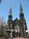 |
January 18, 1974 (#74001452) |
3114 Scranton Rd. 41°28′11″N 81°41′50″W / 41.469722°N 81.697222°W |
|
| 208 | St. Paul's Episcopal Church | 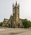 |
November 25, 1980 (#80002979) |
4120 Euclid Ave. 41°30′12″N 81°39′28″W / 41.503333°N 81.657778°W |
|
| 209 | St. Stanislaus Church |  |
June 22, 1976 (#76001404) |
Forman and E. 65th Sts. 41°27′33″N 81°38′41″W / 41.459167°N 81.644722°W |
|
| 210 | St. Stephen Church |  |
November 25, 1977 (#77001052) |
1930 W. 54th St. 41°28′44″N 81°43′26″W / 41.478889°N 81.723889°W |
|
| 211 | St. Theodosius Russian Orthodox Cathedral |  |
January 18, 1974 (#74001453) |
733 Starkweather Ave. 41°28′38″N 81°40′54″W / 41.477222°N 81.681667°W |
|
| 212 | Charles Schweinfurth House |  |
May 22, 1973 (#73001417) |
1915 E. 75th St. 41°30′20″N 81°38′10″W / 41.505417°N 81.636111°W |
|
| 213 | Levi Scofield House | 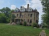 |
December 31, 2019 (#100004823) |
2438 Mapleside Rd. 41°29′30″N 81°36′33″W / 41.4916°N 81.6092°W |
|
| 214 | Scranton South Side Historic District |  |
June 30, 2015 (#15000371) |
2314-2658 and 3339 Scranton Rd., 1632-2101 Holmden, 1644-2115 Brainard, 1724-2105 Corning, and 1701-2034 Clover Aves. 41°27′53″N 81°41′50″W / 41.464722°N 81.697222°W |
|
| 215 | Shaker Square |  |
July 1, 1976 (#76001400) |
Shaker and Moreland Boulevards 41°29′02″N 81°35′26″W / 41.483889°N 81.590556°W |
|
| 216 | Shaker Village Historic District |  |
May 31, 1984 (#84003650) |
Roughly bounded by Fairmount and Lomond Boulevards and Green, Warrensville Center, Becket, and Coventry Rds.; also roughly bounded by Lomond Boulevard, Lytel Rd., Scottsdale Boulevard, and Lindholm Rd. 41°28′33″N 81°33′11″W / 41.475901°N 81.55306°W |
Second set of boundaries represents a boundary increase of January 5, 2001. Extends into Cleveland Heights and Shaker Heights, elsewhere in Cuyahoga County |
| 217 | Shiloh Baptist Church |  |
December 17, 1982 (#82001371) |
5500 Scovill Ave. 41°29′29″N 81°39′04″W / 41.491462°N 81.651219°W |
|
| 218 | Sidaway Bridge |  |
October 3, 2022 (#100008227) |
Sidaway Avenue over Kingsbury Run, connecting Sidaway Ave. and East 67th and Sidaway Ave near Berwick Rd. 41°27′00″N 81°38′34″W / 41.4500°N 81.6428°W |
|
| 219 | Society for Savings Building |  |
November 7, 1976 (#76001401) |
Public Sq. 41°30′02″N 81°41′40″W / 41.500556°N 81.694444°W |
|
| 220 | South Brooklyn Commercial District |  |
February 25, 2005 (#05000092) |
Roughly along Pearl and Broadview Rds. 41°26′30″N 81°42′18″W / 41.441667°N 81.705000°W |
|
| 221 | Southworth House |  |
November 1, 1984 (#84000234) |
3334 Prospect Ave. 41°30′04″N 81°39′48″W / 41.501111°N 81.663333°W |
|
| 222 | J. Spang Baking Company |  |
June 14, 2018 (#100002551) |
2707 Barber Ave. 41°28′31″N 81°42′03″W / 41.4754°N 81.7009°W |
|
| 223 | Stager-Beckwith House |  |
April 20, 1978 (#78002042) |
3813 Euclid Ave. 41°30′14″N 81°39′35″W / 41.503889°N 81.659722°W |
|
| 224 | Stanley Block |  |
April 27, 2011 (#94000591) |
2115-2121 Ontario St. 41°29′52″N 81°41′29″W / 41.497778°N 81.691389°W |
Demolished in December, 2012[28] |
| 225 | Stockbridge Apartment Building |  |
August 8, 1985 (#85001693) |
3328 Euclid Ave. 41°30′10″N 81°39′41″W / 41.502778°N 81.661389°W |
|
| 226 | Stuyvesant Motor Company Building |  |
September 22, 2015 (#15000612) |
1937 E. Prospect Ave. 41°30′02″N 81°40′35″W / 41.500556°N 81.676389°W |
|
| 227 | Superior Avenue Historic District |  |
February 21, 2007 (#07000072) |
1860-2553 Superior Ave. 41°30′29″N 81°40′37″W / 41.508°N 81.677°W |
|
| 228 | Superior Avenue Viaduct |  |
June 9, 1978 (#78002043) |
Superior Ave. 41°29′41″N 81°42′16″W / 41.494722°N 81.704444°W |
|
| 229 | Tavern Club |  |
November 1, 1984 (#84000235) |
3522 Prospect Ave. 41°30′04″N 81°39′47″W / 41.501111°N 81.663056°W |
|
| 230 | Templar-Farrell Motor Sales Building |  |
November 1, 1984 (#84000237) |
3134 Prospect Ave. 41°30′04″N 81°39′55″W / 41.501111°N 81.665278°W |
|
| 231 | The Temple |  |
August 30, 1974 (#74001455) |
University Circle at Silver Park 41°30′29″N 81°36′58″W / 41.508056°N 81.616111°W |
|
| 232 | Templin-Bradley Company |  |
June 14, 2013 (#13000390) |
5700 Detroit Ave. 41°29′07″N 81°43′32″W / 41.485139°N 81.725556°W |
|
| 233 | Third Church of Christ, Scientist |  |
March 19, 1987 (#87000444) |
3648 W. 25th St. 41°27′17″N 81°42′06″W / 41.454722°N 81.701667°W |
|
| 234 | Hannes Tiedemann House |  |
March 15, 1982 (#82004417) |
4308 Franklin Boulevard 41°29′08″N 81°42′59″W / 41.485556°N 81.716389°W |
Commonly known as Franklin Castle |
| 235 | Tinnerman Steel Range Company |  |
February 21, 2017 (#100000663) |
2048 Fulton Rd. 41°28′50″N 81°42′40″W / 41.480556°N 81.711111°W |
Factory building constructed in segments from 1886 to 1914, where the first steel cooking range and the first speed nut was manufactured. |
| 236 | Clayton Townes House |  |
March 19, 1987 (#87000435) |
3800 W. 33rd St. 41°27′06″N 81°42′19″W / 41.451667°N 81.705278°W |
|
| 237 | Tremont Historic District |  |
July 15, 1994 (#94000719) |
Roughly bounded by Interstate 490, Interstate 71, University Ct., W. 7th St., Starkweather Ave., Brayton, Fruit Ave. and Auburn Ave. 41°28′45″N 81°41′16″W / 41.479167°N 81.687778°W |
|
| 238 | Trinity Cathedral |  |
June 4, 1973 (#73001420) |
Euclid Ave. at E. 22nd St. 41°30′04″N 81°40′28″W / 41.501111°N 81.674444°W |
|
| 239 | Trinity Cathedral Church Home |  |
November 1, 1984 (#84000239) |
2227 Prospect Ave. 41°30′02″N 81°40′27″W / 41.500556°N 81.674167°W |
|
| 240 | Union Club |  |
February 15, 1974 (#74001456) |
1211 Euclid Ave. 41°30′12″N 81°41′04″W / 41.503333°N 81.684444°W |
|
| 241 | Union Steel Screw Office Building |  |
January 13, 1989 (#88003193) |
1675-7 E. 40th St. 41°30′50″N 81°39′34″W / 41.513889°N 81.659444°W |
|
| 242 | Union Terminal Group |  |
March 17, 1976 (#76001405) |
Public Sq. 41°29′52″N 81°41′39″W / 41.497778°N 81.694167°W |
|
| 243 | United Motor Service Building |  |
November 1, 1984 (#84000240) |
4019 Prospect Ave. 41°30′09″N 81°39′25″W / 41.502500°N 81.656944°W |
|
| 244 | Universal Terminal Company Dock and Warehouse |  |
September 8, 1983 (#83001954) |
5451 N. Marginal Rd. 41°31′48″N 81°39′20″W / 41.530000°N 81.655556°W |
|
| 245 | University Hall, Cleveland State University |  |
February 6, 1973 (#73001421) |
2605 Euclid Ave. 41°30′11″N 81°40′14″W / 41.503056°N 81.670556°W |
|
| 246 | Upson-Walton Company Building |  |
January 21, 1974 (#74001457) |
1310 Old River Rd. (W. 11th St.) 41°29′53″N 81°42′10″W / 41.498056°N 81.702778°W |
|
| 247 | USS COD (submarine) |  |
January 14, 1986 (#86000088) |
N. Marginal Dr. 41°30′37″N 81°41′32″W / 41.510278°N 81.692222°W |
The USS COD Submarine Memorial is a National Historic Landmark and is docked in Cleveland, Ohio. |
| 248 | Van Rooy Coffee Company Building |  |
June 16, 2004 (#04000608) |
2900 Detroit Ave. 41°29′23″N 81°42′41″W / 41.489722°N 81.711389°W |
|
| 249 | Variety Store Building and Theatre |  |
April 1, 1982 (#82003559) |
11801-11825 Lorain Ave. 41°27′40″N 81°46′14″W / 41.461111°N 81.770556°W |
|
| 250 | Venice Building |  |
October 1, 1990 (#90001496) |
8401-8417 Euclid Ave. 41°30′14″N 81°37′43″W / 41.503889°N 81.628611°W |
Demolished prior to 2003[29] |
| 251 | Vitrolite Building |  |
October 13, 2004 (#04001148) |
2911-2915 Detroit Ave. 41°29′22″N 81°42′42″W / 41.489444°N 81.711667°W |
|
| 252 | Wade Memorial Chapel |  |
June 18, 1973 (#73001422) |
12316 Euclid Ave. inside Lake View Cemetery 41°30′49″N 81°35′42″W / 41.513611°N 81.595°W |
|
| 253 | Wade Park District |  |
October 2, 1982 (#82001372) |
Roughly bounded by E. 105th St., East Boulevard, and Chester and Euclid Aves. 41°30′30″N 81°36′46″W / 41.508333°N 81.612778°W |
|
| 254 | Walker and Weeks Office Building |  |
November 1, 1984 (#84000259) |
2341 Carnegie Ave. 41°29′58″N 81°40′21″W / 41.499444°N 81.6725°W |
|
| 255 | Warner & Swasey Company Building |  |
September 20, 2019 (#100004410) |
5701 Carnegie Ave. 41°30′06″N 81°39′02″W / 41.5016°N 81.6506°W |
|
| 256 | Warszawa Neighborhood District |  |
November 28, 1980 (#80002980) |
E. 65th St. and Forman Ave. 41°27′29″N 81°38′41″W / 41.458056°N 81.644722°W |
|
| 257 | Waterman Service Building |  |
August 17, 2001 (#01000897) |
3030 E. 63rd St. 41°28′34″N 81°38′50″W / 41.476111°N 81.647222°W |
|
| 258 | Watterson School | 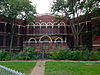 |
October 8, 1992 (#92001354) |
1422 W. 74th St. 41°28′55″N 81°44′10″W / 41.481944°N 81.736111°W |
|
| 259 | Weizer Building |  |
February 8, 1988 (#88000055) |
8935 Buckeye Rd. 41°29′07″N 81°37′25″W / 41.485278°N 81.623611°W |
Demolished[30] |
| 260 | Weizer Building |  |
November 21, 2002 (#02001360) |
11801 Buckeye Rd. 41°28′52″N 81°36′02″W / 41.481111°N 81.600556°W |
|
| 261 | West 25th Street-Detroit Avenue Historic District |  |
January 23, 2013 (#12001214) |
Roughly bounded by Detroit Ave., Aust Ct., W. 25th & W. 28th Sts. 41°29′26″N 81°42′26″W / 41.490556°N 81.707222°W |
|
| 262 | West Side Market |  |
December 18, 1973 (#73001423) |
W. 24th St. and Lorain Ave. 41°29′04″N 81°42′11″W / 41.484444°N 81.703056°W |
|
| 263 | West Technical High School |  |
August 21, 2001 (#01000898) |
2201 W. 93rd St. 41°28′19″N 81°44′48″W / 41.471944°N 81.746667°W |
|
| 264 | Western Reserve Building | 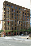 |
October 30, 1973 (#73001424) |
1468 W. 9th St. 41°29′50″N 81°41′59″W / 41.497222°N 81.699722°W |
|
| 265 | Phillis Wheatley Association |  |
August 24, 1979 (#79001809) |
4450 Cedar Ave. 41°30′00″N 81°39′18″W / 41.5°N 81.655°W |
|
| 266 | White Chewing Gum Company Building |  |
March 9, 2000 (#00000181) |
10307 Detroit Ave. 41°28′49″N 81°45′26″W / 41.480278°N 81.757222°W |
|
| 267 | Henry P. White House |  |
July 16, 1973 (#73001425) |
Northwestern corner of Euclid Ave. and E. 90th St. 41°30′14″N 81°37′23″W / 41.503889°N 81.623056°W |
|
| 268 | WHK Studio One |  |
November 1, 2019 (#100004561) |
4900-5002 Euclid Ave. 41°30′14″N 81°39′15″W / 41.5040°N 81.6542°W |
|
| 269 | Woodland Avenue and West Side Railroad Powerhouse |  |
June 4, 1979 (#79001810) |
1180 Cathan Ave., NW 41°29′47″N 81°42′13″W / 41.496389°N 81.703611°W |
|
| 270 | Woodland Cemetery |  |
June 4, 1986 (#86001253) |
6901 Woodland Ave. 41°28′54″N 81°38′30″W / 41.481667°N 81.641667°W |
City cemetery established in 1853 which became Cleveland's most prominent burying ground for the next half-century. It fell into extreme disrepair, and most of its outstanding architectural features dismantled or demolished between 1915 and 1951. It has undergone moderate restoration since 2000. |
| 271 | Woodland-Larchmere Commercial Historic District |  |
September 1, 2015 (#15000560) |
12019-13165 Larchmere and 2618 N. Moreland 41°29′15″N 81°35′35″W / 41.487500°N 81.593056°W |
Extends into Shaker Heights, elsewhere in Cuyahoga County |
| 272 | Zero Gravity Research Facility (B-2) |  |
October 3, 1985 (#85002801) |
Lewis Research Center 41°24′44″N 81°51′51″W / 41.412222°N 81.864167°W |
|
| 273 | Zion Lutheran Church |  |
November 1, 1984 (#84000261) |
2062 E. 30th St. 41°30′02″N 81°40′03″W / 41.500556°N 81.6675°W |
|
| 274 | Zion Lutheran School | 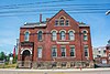 |
November 1, 1984 (#84000264) |
2074 E. 30th St. 41°30′01″N 81°40′02″W / 41.500278°N 81.667222°W |
Former listings edit
| [3] | Name on the Register | Image | Date listed | Date removed | Location | Description |
|---|---|---|---|---|---|---|
| 1 | Cuyahoga Building |  |
December 31, 1974 (#74001436) | May 5, 1983 | 216 Superior Avenue NE |
Imploded on October 3, 1982.[31][32] |
| 2 | Holy Name High School-Gallagher Building | March 27, 1975 (#75001363) | February 21, 1980 | 8318 Broadway SE. |
Demolished | |
| 3 | McDonald's Drive-in | June 15, 1990 (#90000851) | March 21, 1991 | 988 E. 152nd St. |
Demolished | |
| 4 | Newburgh Town Hall |  |
October 30, 1973 (#73001413) | October 29, 1985 | 9213 Miles Park Avenue |
Suffered fire in November 1984, demolished in 1985[33] |
| 5 | Northern Ohio Lunatic Asylum | 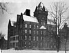 |
October 30, 1973[34] (#73002289) | May 30, 1978 | 4455 Turney Road |
Also known as Newburgh State Hospital and Cleveland State Hospital. Demolished in 1994.[35] |
| 6 | Rocket Engine Test Facility |  |
April 3, 1985 (#85002800) | April 4, 2005 | Lewis Research Center |
Former National Historic Landmark. Demolished in 2003 for runway expansion at the Cleveland Hopkins International Airport.[36] |
| 7 | St. Joseph's Church and Friary | June 17, 1976 (#76001403) | January 31, 1995 | 2543 E. 23rd Street |
Demolished in 1993 after several fires.[37] | |
| 8 | Sterling School | February 25, 1974 (#74001454) | May 5, 1983 | 2104 E. 30th Street |
Demolished in 1982.[38] |
See also edit
References edit
- ^ The latitude and longitude information provided in this table was derived originally from the National Register Information System, which has been found to be fairly accurate for about 99% of listings. Some locations in this table may have been corrected to current GPS standards.
- ^ National Park Service, United States Department of the Interior, "National Register of Historic Places: Weekly List Actions", retrieved April 12, 2024.
- ^ a b Numbers represent an alphabetical ordering by significant words. Various colorings, defined here, differentiate National Historic Landmarks and historic districts from other NRHP buildings, structures, sites or objects.
- ^ a b "National Register Information System". National Register of Historic Places. National Park Service. April 24, 2008.
- ^ The eight-digit number below each date is the number assigned to each location in the National Register Information System database, which can be viewed by clicking the number.
- ^ The Adelbert Hall Fire Archived 2008-12-23 at the Wayback Machine, Case Western Reserve University. Accessed 2007-07-24.
- ^ Allen Memorial Medical Library, Cleveland Landmarks Commission. Accessed 2007-07-24.
- ^ Real Property Information: search for 4345 Lee, Cuyahoga County Auditor, n.d. Accessed 2011-01-24.
- ^ Albrecht, Brian E. (November 26, 1996). "Ball Snaps, Dust Flies At Stadium". The Plan Dealer. p. A1; Grant, Alison (July 6, 1997). "Shortage of Stadium Job Data Frustrates Countil Into Action". The Plan Dealer. p. B1.
- ^ "Cleveland Worsted Mill Co". Encyclopedia of Cleveland History. May 13, 1998. Retrieved January 21, 2011.
- ^ Zipay, Keri (2010-01-11). "The demolition of the Cleveland Cadillac Company building". Cleveland Area History. Retrieved 2013-04-21.
- ^ Murphy, Elizabeth C.; Little, Emily S.; Sanbury, Michael; Jorge, Maria (2014). "Erie Railroad Cleveland Powerhouse" (PDF). Historic American Engineering Record. Washington, D.C.: Library of Congress. Retrieved May 26, 2020.
- ^ Zoning Map Archived 2009-09-20 at the Wayback Machine, Cleveland Heights Department of Planning and Development, November 2005. Accessed 2009-09-05.
- ^ Plan of Lake View Cemetery Archived 2011-07-13 at the Wayback Machine, Lake View Cemetery. Accessed 2009-09-08.
- ^ Jacob Goldsmith House, Encyclopedia of Cleveland History, 1997-07-17. Accessed 2011-01-21.
- ^ Ireland, Joseph House, Ohio Historical Society, 2007. Accessed 2011-01-21.
- ^ Location derived from this National Park Service webpage; the NRIS lists the site as "Address Restricted"
- ^ Wickham, Gertrude Van Rensselaer (1914). The Pioneer Families of Cleveland 1796 - 1840 Vol. 1. Cleveland, Ohio: Evangelical Publishing House. p. 130.
- ^ Cigliano, Jan (1991). Showplace of America: Cleveland's Euclid Avenue, 1850-1910. Kent, Ohio: Kent State University Press. pp. 293–95. ISBN 0-87338-445-8.
- ^ Real Property Information (search for 2061 E. 36 St.), Cuyahoga County Auditor, n.d. Accessed 2011-01-21.
- ^ "National Register of Historic Places Registration Form: Moreland Theater Building" (PDF). April 4, 2011. Archived from the original (PDF) on March 29, 2012. Retrieved September 27, 2011.
- ^ Garrett Morgan House, Ohio Historical Society, 2007. Accessed 2011-01-21.
- ^ Neff Apartments, Ohio Historical Society, 2007. Accessed 2011-01-21.
- ^ Real Property Information (search for 3606 Euclid), Cuyahoga County Auditor, n.d. Accessed 2011-01-21.
- ^ Cleveland Area History: Cars, Beer, and the Law, Christopher Busta-Peck, 2010-05-05. Accessed 2011-01-21.
- ^ The Hulett Automatic Ore Unloaders Online, Cleveland Memory Project Accessed 2011-07-15.
- ^ Quad Hall, Ohio Historical Society, 2007. Accessed 2011-01-24.
- ^ "The Stanley Block Building in downtown Cleveland was demolished Saturday". Newsnet5.com. 2012-12-22. Retrieved 2013-04-21.
- ^ Real Property Information, search for 8401 Euclid, Cuyahoga County Auditor, n.d. Accessed 2011-01-24.
- ^ Weizer Building, Ohio Historical Society, 2007. Accessed 2011-01-21.
- ^ "'Implosion' watchers gasp, grope in dust bowl". Akron Beacon Journal. October 4, 1982. p. 1. Retrieved August 14, 2022 – via Newspapers.com.
- ^ "Cuyahoga Building". The Encyclopedia of Cleveland History. Case Western Reserve University. March 27, 1998. Retrieved May 31, 2012.
- ^ "Many Faces of City's History to Be Preserved As Landmarks". The Plain Dealer. December 17, 1973. p. C5; Thoma, Pauline (May 26, 1975). "Area Landmarks Make A Place in Pages of History". The Plain Dealer. p. A17; "Charles W. Thomas". The Plain Dealer. January 12, 1976. p. D9; Beard, David (November 18, 1984). "Miles Ave. Pastor Opens Church to a Burned Out Congregation". The Plain Dealer. p. A24.
- ^ "Department of the Interior: Heritage Conservation and Recreation Service: National Register of Historic Places: Annual Listing of Historic Properties", 43 FR 5162 (February 7, 1978), at p. 5273.
- ^ Torassa, Ulysses (January 25, 1991). "Heirs Seek Return of Land Used for Institution". The Plain Dealer. p. 19; Lubinger, Bill (December 26, 1991). "Broadway Plan Calls for 200 New Homes". The Plain Dealer. p. B1; Lubinger, Bill (April 4, 1993). "New Projects Will Bring 300 Homes to Cleveland". The Plain Dealer. p. F1; Lubinger, Bill (August 14, 1994). "Flexibility Is Key to Condo Plans". The Plain Dealer. p. E1.
- ^ "Withdrawal of Rocket Engine Test Facility, National Historic Landmarks Program (NHL)". Nps.gov. Retrieved 2013-04-21.
- ^ St Joseph's Church and Friary, Ohio Historical Society, 2007. Accessed 2011-01-24.
- ^ Facaros, Dana (August 21, 1982). "Give the Old Schools New Lease On Life". The Plain Dealer. p. B3.
External links edit
- Cleveland Landmarks, as designated by the Cleveland Landmarks Commission