
KNOWPIA
WELCOME TO KNOWPIA

National Register of Historic Places listings in El Dorado County, California 
Summary
This is a list of the National Register of Historic Places listings in El Dorado County, California.

This is intended to be a complete list of the properties and districts on the National Register of Historic Places in El Dorado County, California, United States. Latitude and longitude coordinates are provided for many National Register properties and districts; these locations may be seen together in an online map.[1]
There are 20 properties and districts listed on the National Register in the county, including 1 National Historic Landmark.
This National Park Service list is complete through NPS recent listings posted April 19, 2024.[2]
Current listings edit
| [3] | Name on the Register[4] | Image | Date listed[5] | Location | City or town | Description |
|---|---|---|---|---|---|---|
| 1 | Baldwin Estate |  |
April 1, 1987 (#87000496) |
NW of US 50 and CA 89 jct. on N side of CA 89 38°56′16″N 120°02′46″W / 38.937778°N 120.046111°W | South Lake Tahoe | |
| 2 | Bayley Hotel |  |
December 18, 1978 (#78000660) |
N of Pilot Hill on CA 49 38°50′39″N 121°00′50″W / 38.844167°N 121.013889°W | Pilot Hill | |
| 3 | Coloma |  |
October 15, 1966 (#66000207) |
7 mi. NW of Placerville on CA 49 38°48′03″N 120°53′29″W / 38.800714°N 120.891444°W | Placerville | |
| 4 | Combellack-Blair House |  |
February 14, 1985 (#85000259) |
3059 Cedar Ravine 38°43′40″N 120°47′42″W / 38.727778°N 120.795°W | Placerville | |
| 5 | Confidence Hall |  |
January 4, 1982 (#82002174) |
487 Main St. 38°43′47″N 120°47′59″W / 38.729722°N 120.799722°W | Placerville | |
| 6 | Crawford Ditch | October 21, 1991 (#91001522) |
Address Restricted | Pleasant Valley | ||
| 7 | Eddy Tree Breeding Station | March 31, 1987 (#87000485) |
2480 and 2500 Carson Rd. 38°44′19″N 120°44′17″W / 38.738611°N 120.738056°W | Placerville | ||
| 8 | Episcopal Church of Our Saviour | 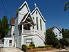 |
November 17, 1977 (#77000291) |
2979 Coloma St. 38°43′48″N 120°48′08″W / 38.73°N 120.802222°W | Placerville | |
| 9 | Fountain-Tallman Soda Works |  |
September 13, 1984 (#84000770) |
524 Main St. 38°43′45″N 120°47′54″W / 38.729167°N 120.798333°W | Placerville | |
| 10 | Georgetown Civil War Armory |  |
September 18, 2017 (#100001601) |
6259 Main St. 38°54′21″N 120°50′22″W / 38.905906°N 120.839405°W | Georgetown | Georgetown CA Civil War Armory, built in 1862, circa 2014. The Armory is the oldest brick building in Georgetown and is the only extant Civil War armory building in El Dorado County, CA |
| 11 | Hattie (Gold Bug), Priest and Silver Pine Mines and Stampmill |  |
November 15, 1985 (#85003522) |
2501 Bedford Ave. 38°44′41″N 120°47′50″W / 38.744722°N 120.797222°W | Placerville | |
| 12 | Heller Estate |  |
April 1, 1987 (#87000497) |
NW of US 50 and CA 89 jct. on N side of CA 89 38°55′59″N 120°02′30″W / 38.933056°N 120.041667°W | South Lake Tahoe | |
| 13 | Lombardo Ranch | September 30, 1977 (#77000292) |
1709 Carson Rd. 38°44′35″N 120°46′24″W / 38.743056°N 120.773333°W | Placerville | ||
| 14 | Mountain Quarries Bridge |  |
February 11, 2004 (#04000014) |
North Fork of the American River 38°54′46″N 121°02′30″W / 38.912792°N 121.041581°W | Auburn | Concrete arch bridge built in 1912, spanning the North Fork of the American River. Spans into Placer County. |
| 15 | John Pearson Soda Works |  |
December 12, 1985 (#85003326) |
594 Main St. 38°43′43″N 120°47′48″W / 38.728611°N 120.796667°W | Placerville | |
| 16 | Pope Estate |  |
April 1, 1987 (#87000495) |
NW of US 50 and CA 89 jct. on N side of CA 89 38°56′14″N 120°02′37″W / 38.937222°N 120.043611°W | South Lake Tahoe | |
| 17 | Sugar Pine Point State Park |  |
March 30, 1973 (#73000401) |
3 mi. S of Homewood on CA 90 39°03′05″N 120°06′47″W / 39.051389°N 120.113056°W | Homewood | |
| 18 | Tahoe Meadows |  |
March 29, 1990 (#90000555) |
US 50 between Ski Run Blvd. and Park Ave. 38°57′13″N 119°57′05″W / 38.953611°N 119.951389°W | South Lake Tahoe | |
| 19 | Vikingsholm | 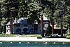 |
October 10, 1996 (#96001078) |
10001 Emerald Bay Rd. 38°57′08″N 120°06′11″W / 38.952222°N 120.103056°W | South Lake Tahoe | |
| 20 | Wakamatsu Tea and Silk Colony Farm | 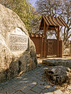 |
October 9, 2009 (#09000397) |
941 Cold Springs Rd. 38°46′15″N 120°53′12″W / 38.770894°N 120.886783°W | Gold Hill |
See also edit
Wikimedia Commons has media related to National Register of Historic Places in El Dorado County, California.
References edit
- ^ The latitude and longitude information provided in this table was derived originally from the National Register Information System, which has been found to be fairly accurate for about 99% of listings. Some locations in this table may have been corrected to current GPS standards.
- ^ National Park Service, United States Department of the Interior, "National Register of Historic Places: Weekly List Actions", retrieved April 19, 2024.
- ^ Numbers represent an alphabetical ordering by significant words. Various colorings, defined here, differentiate National Historic Landmarks and historic districts from other NRHP buildings, structures, sites or objects.
- ^ "National Register Information System". National Register of Historic Places. National Park Service. July 9, 2010.
- ^ The eight-digit number below each date is the number assigned to each location in the National Register Information System database, which can be viewed by clicking the number.