
KNOWPIA
WELCOME TO KNOWPIA

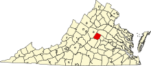
National Register of Historic Places listings in Fluvanna County, Virginia 
Summary
This is a list of the National Register of Historic Places listings in Fluvanna County, Virginia.
This is intended to be a complete list of the properties and districts on the National Register of Historic Places in Fluvanna County, Virginia, United States. The locations of National Register properties and districts for which the latitude and longitude coordinates are included below, may be seen in a Google map.[1]
There are 18 properties and districts listed on the National Register in the county, including 1 National Historic Landmark.
This National Park Service list is complete through NPS recent listings posted April 12, 2024.[2]
Current listings edit
| [3] | Name on the Register[4] | Image | Date listed[5] | Location | City or town | Description |
|---|---|---|---|---|---|---|
| 1 | Bremo Plantation | 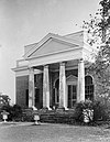 |
November 12, 1969 (#69000241) |
West of Bremo Bluff off U.S. Route 15 37°43′31″N 78°19′47″W / 37.725278°N 78.329722°W | Bremo Bluff | |
| 2 | Bremo Slave Chapel | 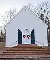 |
March 17, 1980 (#80004189) |
North of Bremo Bluff 37°43′01″N 78°17′50″W / 37.716806°N 78.297222°W | Bremo Bluff | |
| 3 | Fluvanna County Courthouse Historic District | 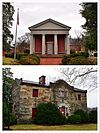 |
September 22, 1971 (#71000977) |
Roughly bounded by Courthouse Rd., U.S. Route 15, and the Rivanna River 37°51′39″N 78°15′52″W / 37.860833°N 78.264306°W | Palmyra | |
| 4 | Glen Arvon |  |
May 28, 1976 (#76002106) |
East of Bremo Bluff near the junction of Bremo and Bottom Rds. 37°42′01″N 78°14′19″W / 37.700278°N 78.238611°W | Bremo Bluff | |
| 5 | Glen Burnie |  |
August 2, 2000 (#00000893) |
U.S. Route 15, 0.25 miles (0.40 km) north of Palmyra 37°52′02″N 78°15′26″W / 37.867239°N 78.257222°W | Palmyra | |
| 6 | Gum Creek |  |
October 22, 2003 (#03001084) |
1317 Stage Junction Rd. 37°46′26″N 78°09′56″W / 37.773889°N 78.165417°W | Columbia | |
| 7 | Laughton |  |
April 1, 2002 (#02000318) |
Perkins Rd. 37°53′47″N 78°06′44″W / 37.896389°N 78.112222°W | Kents Store | |
| 8 | Melrose | 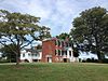 |
August 14, 2000 (#00000892) |
Shores Rd., southwest of its junction with Mountain Hill Rd. 37°44′27″N 78°21′36″W / 37.740833°N 78.360000°W | Fork Union | |
| 9 | The Oaks | 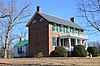 |
July 13, 2001 (#01000696) |
5025 Tabscott Rd. 37°52′24″N 78°05′09″W / 37.873333°N 78.085833°W | Kents Store | |
| 10 | Pleasant Grove |  |
August 12, 2004 (#04000843) |
State Route 53 37°52′21″N 78°17′31″W / 37.872500°N 78.291944°W | Palmyra | |
| 11 | Point of Fork Arsenal |  |
October 1, 1969 (#69000242) |
Point of Fork[6] 37°45′03″N 78°10′03″W / 37.750833°N 78.167500°W | Columbia | |
| 12 | Point of Fork Plantation |  |
August 13, 1974 (#74002116) |
West of Columbia off Point of Fork Rd. 37°45′13″N 78°10′50″W / 37.753611°N 78.180556°W | Columbia | |
| 13 | Rivanna Farm |  |
February 16, 2001 (#01000147) |
Bremo Farms Ln. 37°44′07″N 78°12′21″W / 37.735278°N 78.205833°W | Bremo Bluff | |
| 14 | Scottsville Historic District |  |
July 30, 1976 (#76002093) |
State Route 6 37°47′54″N 78°29′21″W / 37.798333°N 78.489167°W | Scottsville | Extends into Albemarle County |
| 15 | Seay's Chapel Methodist Church |  |
August 22, 2012 (#12000540) |
4916 Shores Rd. 37°44′41″N 78°21′40″W / 37.744722°N 78.361111°W | Palmyra | |
| 16 | Seven Islands Archeological and Historic District |  |
July 3, 1991 (#91000832) |
Address Restricted | Arvonia | Extends into Buckingham County |
| 17 | Union Mills Canal Outlet Locks #1 and #2 |  |
October 14, 1999 (#99001256) |
Rivanna River at the mouth of Boston Creek[7] 37°54′51″N 78°17′41″W / 37.914167°N 78.294722°W | Crofton | |
| 18 | Western View |  |
April 1, 2002 (#02000320) |
Lowfields Ln. 37°44′05″N 78°21′19″W / 37.734861°N 78.355278°W | Fork Union |
See also edit
Wikimedia Commons has media related to National Register of Historic Places in Fluvanna County, Virginia.
References edit
- ^ The latitude and longitude information provided in this table was derived originally from the National Register Information System, which has been found to be fairly accurate for about 99% of listings. Some locations in this table may have been corrected to current GPS standards.
- ^ National Park Service, United States Department of the Interior, "National Register of Historic Places: Weekly List Actions", retrieved April 12, 2024.
- ^ Numbers represent an alphabetical ordering by significant words. Various colorings, defined here, differentiate National Historic Landmarks and historic districts from other NRHP buildings, structures, sites or objects.
- ^ "National Register Information System". National Register of Historic Places. National Park Service. April 24, 2008.
- ^ The eight-digit number below each date is the number assigned to each location in the National Register Information System database, which can be viewed by clicking the number.
- ^ Loth, Calder. The Virginia Landmarks Register. 4th ed. Charlottesville: U of Virginia P, 1999, 171.
- ^ Trout, W.E., III. The Rivanna scenic river atlas. Lexington: Virginia Canals and Navigations Society, 1995, 13.