
KNOWPIA
WELCOME TO KNOWPIA

National Register of Historic Places listings in Hancock County, Kentucky 
Summary
This is a list of the National Register of Historic Places listings in Hancock County, Kentucky.

This is intended to be a complete list of the properties and districts on the National Register of Historic Places in Hancock County, Kentucky, United States. The locations of National Register properties and districts for which the latitude and longitude coordinates are included below, may be seen in a map.[1]
There are 12 properties and districts listed on the National Register in the county.
This National Park Service list is complete through NPS recent listings posted May 10, 2024.[2]
Current listings edit
| [3] | Name on the Register | Image | Date listed[4] | Location | City or town | Description |
|---|---|---|---|---|---|---|
| 1 | Robert C. Beauchamp House | 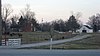 |
July 6, 1976 (#76000894) |
Northwest of Hawesville on U.S. Route 60 37°55′28″N 86°48′22″W / 37.924444°N 86.806111°W | Hawesville | |
| 2 | Hancock County Courthouse |  |
June 18, 1975 (#75000765) |
Courthouse Sq. 37°54′03″N 86°44′58″W / 37.900833°N 86.749444°W | Hawesville | |
| 3 | Hawesville Historic District | 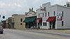 |
April 12, 1984 (#84001536) |
Main, River, Main Cross, and Clay Sts. 37°54′05″N 86°44′58″W / 37.901389°N 86.749444°W | Hawesville | |
| 4 | Isaac R. Hayden House |  |
August 1, 1984 (#84001539) |
Pell St. 37°56′08″N 86°54′19″W / 37.935556°N 86.905139°W | Lewisport | |
| 5 | Tom Henderson House | 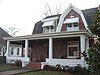 |
August 1, 1984 (#84001540) |
4th St. 37°56′08″N 86°54′06″W / 37.935417°N 86.901667°W | Lewisport | |
| 6 | Immaculate Conception Church |  |
June 18, 1975 (#75000766) |
River St. 37°54′21″N 86°45′13″W / 37.905833°N 86.753611°W | Hawesville | Destroyed |
| 7 | Jeffry Cliff Petroglyphs (15HA114) | September 8, 1989 (#89001191) |
Address Restricted | Indian Lake | ||
| 8 | Lewisport Masonic Lodge |  |
August 1, 1984 (#84001541) |
4th St. 37°56′11″N 86°54′07″W / 37.936389°N 86.901944°W | Lewisport | |
| 9 | Samuel Pate House | December 21, 1978 (#78001335) |
East of Lewisport off Kentucky Route 334 37°58′17″N 86°51′24″W / 37.971389°N 86.856667°W | Lewisport | ||
| 10 | Horace Patterson House |  |
August 1, 1984 (#84001543) |
Market St. 37°56′15″N 86°54′13″W / 37.937500°N 86.903611°W | Lewisport | |
| 11 | Joe Pell Building | 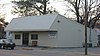 |
August 1, 1984 (#84001544) |
Pell St. 37°56′13″N 86°54′11″W / 37.936944°N 86.903056°W | Lewisport | Small wood frame commercial building, rare as an intact example from the 19th century. Building no longer exists at the site. |
| 12 | J.B. Taylor and Son Feed Store |  |
August 1, 1984 (#84001546) |
307 4th St. 37°56′12″N 86°54′07″W / 37.936528°N 86.901944°W | Lewisport |
See also edit
Wikimedia Commons has media related to National Register of Historic Places in Hancock County, Kentucky.
References edit
- ^ The latitude and longitude information provided in this table was derived originally from the National Register Information System, which has been found to be fairly accurate for about 99% of listings. Some locations in this table may have been corrected to current GPS standards.
- ^ National Park Service, United States Department of the Interior, "National Register of Historic Places: Weekly List Actions", retrieved May 10, 2024.
- ^ Numbers represent an alphabetical ordering by significant words. Various colorings, defined here, differentiate National Historic Landmarks and historic districts from other NRHP buildings, structures, sites or objects.
- ^ The eight-digit number below each date is the number assigned to each location in the National Register Information System database, which can be viewed by clicking the number.