


Summary
This is a list of the National Register of Historic Places designations in Hartford County, Connecticut.
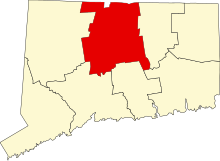
This is intended to be a complete list of the properties and districts on the National Register of Historic Places in Hartford County, Connecticut, United States. The locations of National Register properties and districts for which the latitude and longitude coordinates are included below, may be seen in various online maps.[1]
There are 438 properties and districts listed on the National Register in the county, including 21 National Historic Landmarks. More than half of these listings are in the city of Hartford (144) and the towns of Windsor (41), Southington (41) and West Hartford (32). They are listed separately, while the 190 properties and districts in the remaining parts of the county are listed below. Four properties and districts extend into Hartford, Southington and/or New Haven County and appear in more than one list.
|
Fairfield (city of Bridgeport) (town of Greenwich) (city of Stamford) | Hartford (city of Hartford) (town of Southington) (town of West Hartford) (town of Windsor) | Litchfield | Middlesex (city of Middletown) | New Haven (city of New Haven) | New London | Tolland | Windham |
This National Park Service list is complete through NPS recent listings posted April 19, 2024.[2]
Current listings edit
Hartford edit
Southington edit
West Hartford edit
Windsor edit
Other cities and towns edit
| [3] | Name on the Register[4] | Image | Date listed[5] | Location | City or town | Description |
|---|---|---|---|---|---|---|
| 1 | Academy Hall |  |
October 7, 1977 (#77001419) |
785 Old Main St. 41°39′58″N 72°38′20″W / 41.666111°N 72.638889°W | Rocky Hill | Built in 1803, a Federal style building which served as a school from 1803 to 1941. It was believed to be one of few original Federal style buildings in Connecticut that had been little altered in its exterior.[6] |
| 2 | Allen's Cider Mill |  |
April 28, 1992 (#92000389) |
7 Mountain Rd. 41°59′44″N 72°49′56″W / 41.995556°N 72.832222°W | Granby | Built in 1783; it was one of few surviving wooden cider mills in Connecticut at the time of its collapse in August 2019.[7] [8] |
| 3 | Avon Congregational Church |  |
November 7, 1972 (#72001342) |
Junction of U.S. Routes 44 and 202 41°48′36″N 72°49′52″W / 41.81°N 72.831111°W | Avon | |
| 4 | Babb's Beach |  |
July 12, 2006 (#06000591) |
435 Babbs Rd. 42°01′48″N 72°45′04″W / 42.03°N 72.751111°W | Suffield | |
| 5 | Horace Belden School and Central Grammar School |  |
March 25, 1993 (#93000211) |
933 Hopmeadow St. and 29 Massaco St. 41°52′52″N 72°48′12″W / 41.881111°N 72.803333°W | Simsbury | |
| 6 | Beleden House |  |
March 15, 1982 (#82004392) |
50 Bellevue Ave. 41°40′31″N 72°56′25″W / 41.675278°N 72.940278°W | Bristol | |
| 7 | Makens Bemont House |  |
March 25, 1982 (#82004397) |
307 Burnside Ave. 41°46′33″N 72°37′31″W / 41.775833°N 72.625278°W | East Hartford | |
| 8 | Bigelow-Hartford Carpet Mills Historic District |  |
November 25, 1994 (#94001382) |
Roughly bounded by Lafayette St., Hartford Ave., Alden Ave., and Pleasant, High, Spring, South, and Prospect Sts. 41°59′59″N 72°36′06″W / 41.999722°N 72.601667°W | Enfield | |
| 9 | Bigelow-Hartford Carpet Mills |  |
March 10, 1983 (#83001256) |
Main and Pleasant Sts. 42°00′01″N 72°36′11″W / 42.000278°N 72.603056°W | Enfield | |
| 10 | Clarence A. Bingham School |  |
May 8, 2017 (#100000953) |
3 North St. 41°40′54″N 72°56′57″W / 41.681666°N 72.949247°W | Bristol | |
| 11 | Selden Brewer House |  |
June 4, 1979 (#79002631) |
Naubuc Ave. and Main St. 41°44′06″N 72°37′41″W / 41.734975°N 72.628084°W | East Hartford | |
| 12 | Bridge No. 455 |  |
September 29, 2004 (#04001094) |
CT 159 at Stony Brook 41°57′30″N 72°37′40″W / 41.958333°N 72.627778°W | Suffield | |
| 13 | Bristol Girls' Club |  |
June 3, 1987 (#87000347) |
47 Upson St. 41°40′07″N 72°56′51″W / 41.668611°N 72.9475°W | Bristol | |
| 14 | Bristol High School |  |
June 4, 2018 (#100002506) |
70 Memorial Blvd. 41°40′11″N 72°56′19″W / 41.6698°N 72.9386°W | Bristol | Most recently a middle school. |
| 15 | Broad Brook Company |  |
May 2, 1985 (#85000950) |
Main St. 41°54′58″N 72°32′53″W / 41.916111°N 72.548056°W | East Windsor | |
| 16 | Brown Tavern |  |
May 5, 1972 (#72001339) |
George Washington Turnpike 41°46′07″N 72°57′57″W / 41.768611°N 72.965833°W | Burlington | |
| 17 | Bulkeley Bridge |  |
December 10, 1993 (#93001347) |
Interstate 84 over the Connecticut River 41°46′09″N 72°39′58″W / 41.769167°N 72.666111°W | East Hartford | Extends into Hartford |
| 18 | Edward L. Burnham Farm |  |
April 12, 1982 (#82004436) |
580 Burnham St. W 41°48′03″N 72°34′50″W / 41.800728°N 72.580432°W | Manchester | |
| 19 | Burritt Hotel |  |
July 28, 1983 (#83001257) |
67 W. Main St. 41°40′04″N 72°47′01″W / 41.667778°N 72.783611°W | New Britain | |
| 20 | Ernest R. Burwell House |  |
August 18, 1992 (#92001009) |
161 Grove St. 41°40′54″N 72°56′11″W / 41.681667°N 72.936389°W | Bristol | |
| 21 | Roger Butler House |  |
August 15, 1996 (#96000847) |
146 Jordan Ln. 41°43′24″N 72°40′17″W / 41.723443°N 72.671507°W | Wethersfield | |
| 22 | Buttolph-Williams House |  |
November 24, 1968 (#68000048) |
249 Broad St. 41°42′39″N 72°39′04″W / 41.710833°N 72.651111°W | Wethersfield | Exemplifies traditional early New England design. |
| 23 | Canton Center Historic District |  |
October 7, 1997 (#97000831) |
Roughly along Barbourtown, E. Mountain, Humphrey, West, and W. Mountain Rds. 41°51′28″N 72°54′58″W / 41.857778°N 72.916111°W | Canton | |
| 24 | Case Brothers Historic District |  |
June 30, 2009 (#09000468) |
680-728 Spring St., 40 Glen Rd., and rough boundaries of Case Mountain Recreation Area and Manchester Land 41°45′46″N 72°29′20″W / 41.762708°N 72.489011°W | Manchester | |
| 25 | Cedar Hill Cemetery |  |
April 28, 1997 (#97000333) |
453 Fairfield Ave. 41°43′20″N 72°42′12″W / 41.722222°N 72.703333°W | Newington and Wethersfield | Extends into Hartford |
| 26 | Central Avenue-Center Cemetery Historic District |  |
April 19, 1993 (#93000289) |
Center Ave. from Main St. to Elm St. and Center Cemetery to the north 41°46′09″N 72°38′29″W / 41.769167°N 72.641389°W | East Hartford | |
| 27 | Cheney Brothers Historic District |  |
June 2, 1978 (#78002885) |
Bounded by Hartford Rd. and Laurel, Spruce, and Lampfield Sts. 41°46′00″N 72°31′43″W / 41.766667°N 72.528611°W | Manchester | A nineteenth century silk mill and traditional company town. |
| 28 | City Hall-Monument District |  |
February 28, 1973 (#73001957) |
W. Main St. and Central Park 41°40′05″N 72°46′59″W / 41.668056°N 72.783056°W | New Britain | |
| 29 | Clark Farm Tenant House site |  |
January 31, 2002 (#01001554) |
Address Restricted | East Granby | |
| 30 | Collinsville Historic District |  |
June 23, 1976 (#76001994) |
CT 179 41°48′44″N 72°55′22″W / 41.812222°N 72.922778°W | Canton | |
| 31 | Commercial Trust Company Building |  |
March 17, 2009 (#09000141) |
51–55 West Main Street 41°40′04″N 72°46′59″W / 41.667778°N 72.783056°W | New Britain | |
| 32 | Congregational Church of Plainville |  |
June 27, 2012 (#12000358) |
130 W. Main St. 41°40′12″N 72°52′27″W / 41.670075°N 72.87412°W | Plainville | |
| 33 | Connecticut General Life Insurance Company Headquarters |  |
January 27, 2010 (#09000324) |
900 Cottage Grove Rd. 41°48′49″N 72°44′42″W / 41.813708°N 72.7449°W | Bloomfield | |
| 34 | Copper Ledges and Chimney Crest |  |
August 21, 1992 (#92001010) |
Along Founders Dr. between Bradley and Woodland Sts. 41°40′45″N 72°56′03″W / 41.679167°N 72.934167°W | Bristol | |
| 35 | Frederick H. Cossitt Library |  |
June 22, 1988 (#88000708) |
388 N. Granby Rd. 41°59′45″N 72°49′51″W / 41.995833°N 72.830833°W | Granby | |
| 36 | Abraham Coult House | August 11, 2000 (#00000834) |
1695 Hebron Ave. 41°43′08″N 72°32′39″W / 41.718889°N 72.544167°W | Glastonbury | ||
| 37 | Gen. George Cowles House |  |
May 11, 1982 (#82004400) |
130 Main St. 41°43′03″N 72°50′09″W / 41.7175°N 72.835833°W | Farmington | |
| 38 | Whitfield Cowles House |  |
April 8, 2014 (#13000528) |
118 Spoonville Rd. 41°54′05″N 72°44′45″W / 41.901522°N 72.745905°W | East Granby | |
| 39 | Curtisville Historic District |  |
December 14, 1992 (#92001638) |
Roughly Pratt St. from Naubuc Ave. to the west of Main St., also Parker Terrace; Parker Terrace extended and adjacent parts of Naubuc 41°43′03″N 72°37′03″W / 41.7175°N 72.6175°W | Glastonbury | |
| 40 | Robert and Julia Darling House |  |
January 3, 1991 (#90002117) |
720 Hopmeadow St. 41°52′20″N 72°48′10″W / 41.872222°N 72.802778°W | Simsbury | |
| 41 | Silas Deane House |  |
October 6, 1970 (#70000835) |
203 Main St. 41°41′42″N 72°39′13″W / 41.695°N 72.653611°W | Wethersfield | Home of America's first foreign diplomat |
| 42 | Downtown Main Street Historic District |  |
December 20, 1996 (#96001464) |
Roughly bounded by Main St., Governor St., Chapman Pl., and Burnside Ave. 41°46′20″N 72°38′31″W / 41.772347°N 72.641808°W | East Hartford | |
| 43 | Downtown New Britain | |
May 3, 2016 (#16000210) |
Roughly bounded by CT 72, Main St., Franklin Sq., Whiting St., Arch St., and High St. 41°39′41″N 72°46′47″W / 41.661393°N 72.779767°W | New Britain | |
| 44 | Drake Hill Road Bridge |  |
July 19, 1984 (#84000999) |
Drake Hill Rd. at the Farmington River 41°52′06″N 72°48′01″W / 41.868333°N 72.800278°W | Simsbury | |
| 45 | East Granby Historic District |  |
August 25, 1988 (#88001318) |
Church and East Sts., Nicholson and Rainbow Rds., N. Main, School and S. Main Sts. 41°56′32″N 72°43′28″W / 41.942222°N 72.724444°W | East Granby | |
| 46 | East Weatogue Historic District |  |
July 19, 1990 (#90001107) |
Roughly properties on East Weatogue St. from just north of Riverside Dr. to Hartford Rd., and Folly Farm property to the south 41°50′51″N 72°47′58″W / 41.8475°N 72.799444°W | Simsbury | |
| 47 | East Windsor Academy |  |
December 3, 1998 (#98000359) |
115 Scantic Rd. 41°54′02″N 72°34′49″W / 41.900556°N 72.580278°W | East Windsor | |
| 48 | East Windsor Hill Historic District |  |
May 30, 1986 (#86001208) |
Roughly bounded by the Scantic River, John Fitch Boulevard, Sullivan Ave., and the Connecticut River 41°51′23″N 72°36′45″W / 41.856389°N 72.6125°W | South Windsor | |
| 49 | Elm Street Historic District |  |
April 13, 1998 (#98000358) |
18-191 Elm St. 41°39′53″N 72°38′40″W / 41.664722°N 72.644444°W | Rocky Hill | |
| 50 | Elmore Houses |  |
August 23, 1985 (#85001832) |
78 and 87 Long Hill Rd. 41°48′10″N 72°35′42″W / 41.802778°N 72.595°W | South Windsor | |
| 51 | Endee Manor Historic District |  |
February 29, 1996 (#96000027) |
Roughly along Sherman, Mills and Putnam Sts. 41°40′44″N 72°57′28″W / 41.678889°N 72.957778°W | Bristol | |
| 52 | Enfield Canal |  |
April 22, 1976 (#76001998) |
Along the Connecticut River from Windsor Locks north to Thompsonville 41°57′00″N 72°37′10″W / 41.95°N 72.619444°W | Windsor Locks | |
| 53 | Enfield Historic District |  |
August 10, 1979 (#79002664) |
1106-1492 Enfield St. 41°58′34″N 72°35′37″W / 41.976111°N 72.593611°W | Enfield | |
| 54 | Enfield Shakers Historic District |  |
May 21, 1979 (#79002663) |
Shaker, Taylor, and Cybulski Rds. 42°00′42″N 72°30′57″W / 42.011667°N 72.515833°W | Enfield | |
| 55 | Enfield Town Meetinghouse |  |
September 10, 1974 (#74002050) |
Enfield St. at South Rd. 41°58′37″N 72°35′33″W / 41.976965°N 72.592447°W | Enfield | |
| 56 | Eno Memorial Hall |  |
April 2, 1993 (#93000210) |
754 Hopmeadow St. 41°52′28″N 72°48′06″W / 41.874444°N 72.801667°W | Simsbury | |
| 57 | Amos Eno House |  |
April 3, 1975 (#75001935) |
Off U.S. Route 202 on Hopmeadow Rd. 41°52′21″N 72°48′14″W / 41.8725°N 72.803889°W | Simsbury | |
| 58 | Erwin Home for Worthy and Indigent Women |  |
April 12, 2002 (#02000332) |
140 Bassett St. 41°39′26″N 72°46′48″W / 41.657222°N 72.78°W | New Britain | |
| 59 | Farmington Canal-New Haven and Northampton Canal |  |
September 12, 1985 (#85002664) |
Roughly from Suffield in Hartford County to New Haven in New Haven County 41°37′14″N 72°51′54″W / 41.620556°N 72.865°W | Avon, East Granby, Farmington, Granby, Plainville, Simsbury, Suffield | Extends into Southington and New Haven County. First a canal, later a railroad, and now a multi-use trail. |
| 60 | Farmington Historic District |  |
March 17, 1972 (#72001331) |
Porter and Mountain Rds., Main and Garden Sts., Hatter's and Hillstead Lanes, and Farmington Ave. 41°43′11″N 72°49′45″W / 41.719722°N 72.829167°W | Farmington | |
| 61 | Federal Hill Historic District |  |
August 28, 1986 (#86001989) |
Roughly bounded by Summer, Maple, Woodland, Goodwin, and High Sts. 41°40′35″N 72°56′27″W / 41.676389°N 72.940833°W | Bristol | |
| 62 | Capt. Oliver Filley House |  |
May 15, 2007 (#07000420) |
130 Mountain Ave. 41°50′05″N 72°45′44″W / 41.8347°N 72.7623°W | Bloomfield | |
| 63 | First Church of Christ |  |
May 15, 1975 (#75002056) |
75 Main St. 41°43′14″N 72°49′47″W / 41.720556°N 72.829722°W | Farmington | Church of the Amistad freed slaves. |
| 64 | First Congregational Church of East Hartford and Parsonage |  |
March 25, 1982 (#82004398) |
829-837 Main St. 41°46′08″N 72°38′41″W / 41.768889°N 72.644722°W | East Hartford | |
| 65 | First Lutheran Church of the Reformation |  |
August 30, 2010 (#10000825) |
77 Franklin Square 41°39′46″N 72°46′50″W / 41.662778°N 72.780556°W | New Britain | |
| 66 | Forestville Passenger Station |  |
April 19, 1978 (#78002862) |
171 Central St. 41°40′24″N 72°53′54″W / 41.673333°N 72.898333°W | Bristol | |
| 67 | John Fuller House |  |
March 15, 1982 (#82004439) |
463 Halliday Ave. 42°01′03″N 72°39′27″W / 42.017390°N 72.657550°W | Suffield | |
| 68 | Garvan-Carroll Historic District |  |
August 26, 1991 (#91001049) |
Roughly bounded by S. Prospect, Chapel and Main Sts., and Interstate 84 41°46′01″N 72°38′52″W / 41.766944°N 72.647778°W | East Hartford | |
| 69 | Francis Gillette House |  |
March 25, 1982 (#82004391) |
559 Bloomfield Ave. 41°48′51″N 72°44′15″W / 41.814049°N 72.737431°W | Bloomfield | |
| 70 | Gilman-Hayden House |  |
August 16, 1984 (#84001007) |
1871 Main St. 41°47′30″N 72°38′01″W / 41.791540°N 72.633614°W | East Hartford | |
| 71 | Glastonbury Historic District |  |
August 2, 1984 (#84001011) |
Roughly Main St. from Hebron Ave. to Talcott Rd. 41°42′09″N 72°36′34″W / 41.7025°N 72.609444°W | Glastonbury | |
| 72 | Glastonbury-Rocky Hill Ferry Historic District |  |
September 21, 2005 (#05001046) |
Roughly along Tryon St., Ferry Ln. and Glastonbury Ave., Meadow and Riverview Rds. 41°39′46″N 72°37′19″W / 41.662778°N 72.621944°W | Glastonbury | |
| 73 | Gothic Cottage |  |
February 25, 1982 (#82004441) |
1425 Mapleton Ave. 42°01′04″N 72°37′17″W / 42.017778°N 72.621389°W | Suffield | |
| 74 | Granby Center Historic District |  |
October 17, 1985 (#85003149) |
3-8 E. Granby Rd., 2 Park Pl., and 207-265 Salmon Brook St. S 41°57′00″N 72°47′33″W / 41.95°N 72.7925°W | Granby | |
| 75 | Ebenezer Grant House |  |
September 19, 1977 (#77001408) |
1653 Main St. 41°51′05″N 72°36′31″W / 41.851389°N 72.608611°W | South Windsor | |
| 76 | Gridley-Parsons-Staples Homestead |  |
July 30, 1981 (#81000537) |
1554 Farmington Ave. 41°44′56″N 72°52′08″W / 41.748984°N 72.868761°W | Farmington | |
| 77 | Dr. Elizur Hale House |  |
November 13, 1989 (#89001088) |
3181 Hebron Ave. 41°42′29″N 72°28′44″W / 41.708056°N 72.478889°W | Glastonbury | |
| 78 | Hart's Corner Historic District |  |
July 8, 1987 (#87000351) |
247 Monce Rd. and 102 and 105 Stafford Rd. 41°43′41″N 72°54′50″W / 41.728056°N 72.913889°W | Burlington | |
| 79 | Hastings Hill Historic District |  |
September 14, 1979 (#79002669) |
987-1308 Hill St., 1242 Spruce St., and 1085-1162 Russell Ave. 42°00′35″N 72°40′38″W / 42.009722°N 72.677222°W | Suffield | |
| 80 | Hatheway House |  |
August 6, 1975 (#75001934) |
55 S. Main St. 41°58′48″N 72°39′10″W / 41.98°N 72.652778°W | Suffield | |
| 81 | Samuel Hayes II House |  |
April 27, 1992 (#92000390) |
67 Barndoor Hills Rd. 41°56′42″N 72°49′06″W / 41.945°N 72.818333°W | Granby | |
| 82 | Hazardville Historic District |  |
February 19, 1980 (#80004061) |
Hazardville (near CT 190 and CT 192) 41°58′33″N 72°31′54″W / 41.975833°N 72.531667°W | Enfield | |
| 83 | Heublein Tower | 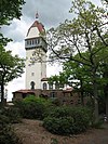 |
June 30, 1983 (#83001260) |
Talcott Mountain State Park 41°49′25″N 72°47′51″W / 41.823611°N 72.7975°W | Simsbury | |
| 84 | Hill-Stead |  |
July 17, 1991 (#91002056) |
35 Mountain Rd. 41°43′13″N 72°49′09″W / 41.720278°N 72.819167°W | Farmington | Colonial revival house and art museum located in the Farmington Historic District |
| 85 | Hilltop Farm |  |
January 12, 2005 (#04001463) |
1550-1760 Mapleton Ave. 42°01′30″N 72°36′50″W / 42.025°N 72.613889°W | Suffield | |
| 86 | Hitchcock-Schwarzmann Mill |  |
September 13, 1977 (#77001409) |
North of Burlington at Foote and Vineyard Rds. 41°46′54″N 72°57′42″W / 41.781667°N 72.961667°W | Burlington | Main mill building demolished. |
| 87 | Judah Holcomb House |  |
June 16, 1988 (#88000755) |
257 N. Granby Rd. 41°58′50″N 72°49′08″W / 41.980556°N 72.818889°W | Granby | The house experienced a significant fire and was subsequently demolished. The doorway survived the fire and is now at Historic Deerfield.[9] |
| 88 | Nathaniel Holcomb III House |  |
April 29, 1982 (#82004486) |
45 Bushy Hill Rd. 41°57′00″N 72°48′40″W / 41.95°N 72.811111°W | Granby | |
| 89 | John Hollister House |  |
November 7, 1972 (#72001329) |
14 Tryon St. 41°40′01″N 72°36′32″W / 41.666944°N 72.608889°W | Glastonbury | |
| 90 | Francis H. Holmes House |  |
June 28, 1984 (#84001014) |
349 Rocky Hill Ave. 41°39′14″N 72°45′34″W / 41.653889°N 72.759444°W | New Britain | |
| 91 | Henry Hooker House |  |
November 29, 1978 (#78002867) |
111 High Rd. 41°38′41″N 72°47′22″W / 41.644722°N 72.789444°W | Berlin | |
| 92 | Hubbard Park |  |
December 15, 1997 (#97001466) |
Roughly bounded by W. Main St., Interstate 691, CT 66, Reservoir Ave., Edgewood Dr. 41°33′45″N 72°50′05″W / 41.5625°N 72.834722°W | Berlin | A park partly in Berlin, Southington, and Meriden. |
| 93 | John Humphrey House |  |
November 15, 1990 (#90001755) |
115 E. Weatogue St. 41°51′48″N 72°47′43″W / 41.863333°N 72.795278°W | Simsbury | |
| 94 | William Jerome I House |  |
June 2, 1987 (#87000792) |
367 Jerome Ave. 41°41′59″N 72°55′46″W / 41.699722°N 72.929444°W | Bristol | |
| 95 | Gen. Martin Kellogg House |  |
October 1, 1987 (#87001770) |
679 Willard Ave. 41°41′53″N 72°44′04″W / 41.698056°N 72.734444°W | Newington | The home of General Martin Kellog III, also known as the Kellogg-Eddy House |
| 96 | Enoch Kelsey House |  |
June 28, 1982 (#82004437) |
1702 Main St. 41°41′07″N 72°43′17″W / 41.685352°N 72.721468°W | Newington | |
| 97 | Ezekiel Kelsey House |  |
September 16, 1977 (#77001410) |
429 Beckley Rd. 41°37′43″N 72°43′24″W / 41.628611°N 72.723333°W | Berlin | |
| 98 | Kensington Grammar School-Jean E. Hooker High School |  |
June 27, 2012 (#12000360) |
462 Alling St. 41°38′02″N 72°46′15″W / 41.63392°N 72.770909°W | Berlin | Demolished.[10] |
| 99 | Kensington Soldier's Monument |  |
July 3, 2013 (#13000456) |
312 Percival Avenue 41°37′22″N 72°46′59″W / 41.62288°N 72.78298°W | Berlin | |
| 100 | Kimberly Mansion |  |
September 17, 1974 (#74002178) |
1625 Main St. 41°41′22″N 72°36′26″W / 41.689444°N 72.607222°W | Glastonbury | Home of Abby and Julia Evelina Smith, suffragists who fought the town of Glastonbury and won. |
| 101 | King's Field House |  |
March 11, 1982 (#82004440) |
827 North St. 42°00′26″N 72°38′42″W / 42.007222°N 72.645°W | Suffield | |
| 102 | Alexander King House |  |
April 26, 1976 (#76001993) |
232 S. Main St. 41°58′31″N 72°39′12″W / 41.975278°N 72.653333°W | Suffield | |
| 103 | Landers, Frary and Clark Ellis Street Plant Historic District | August 1, 2022 (#100007948) |
321 and 322 Ellis St. 41°39′29″N 72°46′10″W / 41.6581°N 72.7695°W | New Britain | ||
| 104 | Lewis-Zukowski House |  |
February 21, 1990 (#90000147) |
1095 S. Grand St. 41°57′41″N 72°42′41″W / 41.961389°N 72.711389°W | Suffield | |
| 105 | Main Street Historic District |  |
August 15, 1995 (#95001006) |
Roughly Main St. from School St. to Summer St. and adjacent areas of Prospect St. 41°40′19″N 72°56′35″W / 41.671944°N 72.943056°W | Bristol | |
| 106 | Main Street Historic District |  |
April 18, 1996 (#96000428) |
Roughly Main St. from Center St. to Eldridge St. 41°46′16″N 72°31′18″W / 41.771111°N 72.521667°W | Manchester | |
| 107 | Manchester Historic District |  |
August 2, 2000 (#00000857) |
Roughly bounded by Center Spring Park, Main St., Interstate 384, and Campfield Rd. 41°46′12″N 72°31′42″W / 41.77°N 72.528333°W | Manchester | |
| 108 | Marlborough Congregational Church |  |
December 10, 1993 (#93001346) |
35 S. Main St. 41°37′44″N 72°27′19″W / 41.628889°N 72.455278°W | Marlborough | |
| 109 | Marlborough House |  |
September 2, 1993 (#93000906) |
226 Grove St. 41°40′52″N 72°56′02″W / 41.681111°N 72.933889°W | Bristol | |
| 110 | Marlborough Tavern |  |
December 6, 1978 (#78002866) |
Off CT 66 41°37′52″N 72°27′35″W / 41.631111°N 72.459722°W | Marlborough | |
| 111 | Masonic Temple |  |
July 21, 1995 (#95000864) |
265 W. Main St. 41°39′57″N 72°47′27″W / 41.665833°N 72.790833°W | New Britain | |
| 112 | Massacoe Forest Pavilion |  |
September 4, 1986 (#86001731) |
Off Old Farms Rd., Stratton Brook State Park 41°51′49″N 72°50′10″W / 41.8636°N 72.8361°W | Simsbury | |
| 113 | Melrose |  |
August 26, 2010 (#10000577) |
Broad Brook Rd. and Melrose Rd. 41°56′15″N 72°31′38″W / 41.9375°N 72.5272°W | East Windsor | |
| 114 | Melrose Road Bridge |  |
August 5, 1999 (#99000922) |
Melrose Rd. over the Scantic River 41°56′18″N 72°32′51″W / 41.938333°N 72.5475°W | East Windsor | |
| 115 | Memorial Hall |  |
June 2, 1987 (#87000802) |
Junction of S. Main and Elm Sts. 41°55′29″N 72°37′38″W / 41.924619°N 72.627315°W | Windsor Locks | |
| 116 | J. R. Montgomery Company Industrial Complex |  |
December 29, 2017 (#100001915) |
25 Canal Bank Rd. 41°55′46″N 72°37′36″W / 41.929465°N 72.626710°W | Windsor Locks | |
| 117 | Naubuc Avenue-Broad Street Historic District |  |
December 4, 1998 (#98001439) |
Roughly along Broad St. and Naubuc Ave. 41°43′48″N 72°37′38″W / 41.73°N 72.627222°W | East Hartford | |
| 118 | New Britain Opera House |  |
October 7, 1977 (#77001421) |
466-468 Main St. 41°40′14″N 72°46′55″W / 41.670556°N 72.781944°W | New Britain | Demolished. |
| 119 | New Britain Public High School Campus |  |
March 23, 2015 (#15000101) |
50 Bassett & 161 S. Main Sts. 41°39′38″N 72°46′48″W / 41.6606°N 72.7801°W | New Britain | Converted to residences. |
| 120 | New Haven District Campground |  |
May 19, 1980 (#80004065) |
Off CT 177 41°41′10″N 72°53′23″W / 41.686111°N 72.889722°W | Plainville | |
| 121 | Newington Junction North Historic District |  |
June 2, 1987 (#86003465) |
55-108 Willard Ave. 41°43′05″N 72°44′15″W / 41.718056°N 72.7375°W | Newington | |
| 122 | Newington Junction Railroad Depot |  |
December 22, 1986 (#86003478) |
160 Willard and 200 Francis Aves. 41°42′55″N 72°44′13″W / 41.715278°N 72.736944°W | Newington | |
| 123 | Newington Junction South Historic District |  |
June 2, 1987 (#86003462) |
268-319 Willard Ave. 41°42′41″N 72°44′15″W / 41.711389°N 72.7375°W | Newington | |
| 124 | Newington Junction West Historic District |  |
June 2, 1987 (#86003464) |
175 and 181-183 Willard Ave. and 269-303 W. Hill Rd. 41°42′54″N 72°44′21″W / 41.715°N 72.739167°W | Newington | |
| 125 | Newington VA Hospital Historic District | July 5, 2022 (#100007860) |
555 Willard Ave. 41°42′08″N 72°44′07″W / 41.7023°N 72.7352°W | Newington | ||
| 126 | Charles H. Norton House |  |
May 11, 1976 (#76002139) |
132 Redstone Hill 41°39′32″N 72°53′06″W / 41.658889°N 72.885°W | Plainville | Home of the inventor of precision grinding equipment. |
| 127 | Old Farm Schoolhouse |  |
October 18, 1972 (#72001340) |
Junction of Park Ave. and School St. 41°49′25″N 72°42′32″W / 41.823611°N 72.708889°W | Bloomfield | |
| 128 | Old Newgate Prison |  |
October 15, 1970 (#70000839) |
Newgate Rd. 41°57′43″N 72°44′44″W / 41.961944°N 72.745556°W | East Granby | Colonial prison; loyalists were held here during the American Revolutionary War |
| 129 | Old Wethersfield Historic District |  |
December 29, 1970 (#70000719) |
Bounded by Hartford, railroad tracks, Interstate 91, and Rocky Hill 41°42′32″N 72°39′23″W / 41.708889°N 72.656389°W | Wethersfield | |
| 130 | Clara T. O'Connell School |  |
May 8, 2017 (#100000954) |
122 Park St. 41°40′20″N 72°57′16″W / 41.672353°N 72.954430°W | Bristol | |
| 131 | Pequabuck Bridge |  |
July 19, 1984 (#84001049) |
Meadow Rd. at the Pequabuck River 41°42′59″N 72°50′25″W / 41.716389°N 72.840278°W | Farmington | |
| 132 | Capt. Elisha Phelps House |  |
September 22, 1972 (#72001345) |
800 Hopmeadow St. 41°52′34″N 72°48′05″W / 41.876111°N 72.801389°W | Simsbury | |
| 133 | Ezekiel Phelps House |  |
February 25, 1982 (#82004396) |
38 Holcomb St. 41°56′36″N 72°44′47″W / 41.943333°N 72.746389°W | East Granby | |
| 134 | Pine Grove Historic District |  |
February 11, 1980 (#80004066) |
CT 167 41°46′09″N 72°51′25″W / 41.769167°N 72.856944°W | Avon | |
| 135 | David Pinney House and Barn |  |
July 25, 1977 (#77001415) |
58 West St. 41°55′57″N 72°38′24″W / 41.9325°N 72.64°W | Windsor Locks | Now the Noden-Reed Museum. |
| 136 | Pitkin Glassworks Ruin |  |
April 9, 1979 (#79002628) |
corner of Putnam and Parker Streets 41°46′36″N 72°30′15″W / 41.776593°N 72.504126°W | Manchester | |
| 137 | John Robbins House |  |
September 20, 1988 (#88001526) |
262 Old Main St. 41°40′42″N 72°38′43″W / 41.678272°N 72.645405°W | Rocky Hill | |
| 138 | Unni Robbins II House |  |
September 21, 2005 (#05001049) |
1692 Main St. 41°41′09″N 72°43′17″W / 41.685710°N 72.721523°W | Newington | |
| 139 | Rockwell Park |  |
May 21, 1987 (#87000788) |
Dutton Ave. and Jacobs St. 41°40′26″N 72°57′43″W / 41.673896°N 72.961952°W | Bristol | |
| 140 | Rocky Hill Center Historic District |  |
March 9, 2007 (#07000111) |
Roughly bounded by Old Main, Pratt, and Washington Sts., Glastonbury Ave., and Riverview Rd. 41°39′54″N 72°38′06″W / 41.664947°N 72.634933°W | Rocky Hill | |
| 141 | Rocky Hill Congregational Church |  |
May 7, 1982 (#82004438) |
805-817 Old Main St. 41°39′56″N 72°38′21″W / 41.665556°N 72.639167°W | Rocky Hill | |
| 142 | Rowe and Weed Houses |  |
January 18, 1978 (#78002860) |
208 Salmon Brook St. 41°56′45″N 72°47′27″W / 41.945833°N 72.790833°W | Granby | |
| 143 | St. John's Episcopal Church |  |
November 28, 1983 (#83003567) |
1160 Main St. 41°46′25″N 72°38′27″W / 41.773611°N 72.640833°W | East Hartford | |
| 144 | St. John's Episcopal Church |  |
April 27, 1982 (#82004442) |
92 Main St. 41°55′43″N 72°37′06″W / 41.928611°N 72.618333°W | East Windsor | |
| 145 | St. Mary's Parochial School |  |
April 3, 1991 (#91000364) |
Beaver St. south of Broad St. 41°40′18″N 72°46′58″W / 41.671667°N 72.782778°W | New Britain | |
| 146 | Shade Swamp Shelter |  |
September 4, 1986 (#86001746) |
U.S. Route 6 east of New Britain Ave. 41°42′15″N 72°51′35″W / 41.704167°N 72.859722°W | Farmington | |
| 147 | Simeon North Factory Site |  |
August 18, 1990 (#90001158) |
Address Restricted | Berlin | |
| 148 | Simsbury Bank and Trust Company Building |  |
November 20, 1986 (#86003323) |
760-762 Hopmeadow St. 41°52′31″N 72°48′06″W / 41.875278°N 72.801667°W | Simsbury | |
| 149 | Simsbury Center Historic District |  |
April 12, 1996 (#96000356) |
Roughly Hopmeadow St. from West St. to Massaco St. 41°52′31″N 72°48′11″W / 41.875278°N 72.803056°W | Simsbury | |
| 150 | Simsbury Railroad Depot |  |
March 26, 1976 (#76001997) |
Railroad Ave. at Station St. 41°52′27″N 72°48′02″W / 41.874167°N 72.800556°W | Simsbury | |
| 151 | Simsbury Townhouse |  |
April 2, 1993 (#93000209) |
695 Hopmeadow St. 41°52′18″N 72°48′17″W / 41.871667°N 72.804722°W | Simsbury | |
| 152 | Sloper-Wesoly House |  |
January 7, 1999 (#98001577) |
27 Grove Hill St. 41°40′00″N 72°47′30″W / 41.666667°N 72.791667°W | New Britain | |
| 153 | South Congregational Church |  |
April 6, 1990 (#89000930) |
90 Main St. 41°39′54″N 72°46′56″W / 41.665°N 72.782222°W | New Britain | |
| 154 | South End Historic District |  |
January 19, 2001 (#00001625) |
Roughly bounded by East Rd., Willis St., George St., and South St. 41°39′55″N 72°56′33″W / 41.665278°N 72.9425°W | Bristol | |
| 155 | South Glastonbury Historic District |  |
November 23, 1984 (#84000250) |
High, Hopewell, Main, and Water Sts.; also 999-1417 and 1032-1420 Main St., 6 and 7 Chestnut Hill Rd. 41°39′59″N 72°36′15″W / 41.666389°N 72.604167°W | Glastonbury | Second set of boundaries represent a boundary increase of September 24, 2009 |
| 156 | Southwest District School |  |
July 24, 1992 (#92000904) |
430 Simsbury Rd. 41°49′04″N 72°46′02″W / 41.817778°N 72.767222°W | Bloomfield | |
| 157 | Stanley-Whitman House |  |
October 15, 1966 (#66000882) |
37 High St. 41°43′16″N 72°49′32″W / 41.721111°N 72.825556°W | Farmington | Classic seventeenth-century New England saltbox. |
| 158 | Suffield Historic District |  |
September 25, 1979 (#79003750) |
Runs along N. and S. Main St. 41°58′51″N 72°39′06″W / 41.980833°N 72.651667°W | Suffield | |
| 159 | Tariffville Historic District |  |
April 2, 1993 (#93000173) |
Roughly bounded by Winthrop St., Main St., Mountain Rd., Laurel Hill Rd., and Elm St. 41°54′36″N 72°45′53″W / 41.91°N 72.764722°W | Simsbury | |
| 160 | Tephereth Israel Synagogue |  |
May 11, 1995 (#95000576) |
76 Winter St. 41°40′19″N 72°46′44″W / 41.671944°N 72.778889°W | New Britain | |
| 161 | Terry's Plain Historic District |  |
December 10, 1993 (#93001417) |
Roughly bounded by Pharos, Quarry, and Terry's Plain Rds., and the Farmington River 41°53′01″N 72°47′05″W / 41.883611°N 72.784722°W | Simsbury | |
| 162 | Terry-Hayden House |  |
March 25, 1982 (#82004393) |
125 Middle St. 41°39′57″N 72°55′17″W / 41.665833°N 72.921389°W | Bristol | |
| 163 | William H. Thompson Farmstead |  |
April 18, 2003 (#03000234) |
215 and 219 Melrose Rd. 41°56′16″N 72°31′22″W / 41.937778°N 72.522778°W | East Windsor | |
| 164 | Town Bridge |  |
August 5, 1999 (#99000923) |
Town Bridge over the Farmington River 41°49′28″N 72°55′43″W / 41.824444°N 72.928611°W | Canton | |
| 165 | Townsend G. Treadway House |  |
December 19, 1991 (#91001871) |
100 Oakland St. 41°40′51″N 72°56′10″W / 41.680833°N 72.936111°W | Bristol | |
| 166 | Treadwell House |  |
April 27, 1982 (#82004395) |
George Washington Turnpike 41°46′08″N 72°57′52″W / 41.768961°N 72.964574°W | Burlington | |
| 167 | Trinity Methodist Episcopal Church |  |
July 21, 2007 (#07000697) |
69 Main St. 41°39′56″N 72°46′51″W / 41.665447°N 72.780946°W | New Britain | |
| 168 | Tunxis Forest Headquarters House | September 4, 1986 (#86001759) |
Western side of Pell Rd. 0.2 miles (0.32 km) north of Town Rd. 42°00′51″N 72°54′58″W / 42.014082°N 72.916105°W | Hartland | ||
| 169 | Tunxis Forest Ski Cabin |  |
September 5, 1986 (#86001761) |
Western end of Balance Rock Rd. 42°00′32″N 72°55′47″W / 42.008889°N 72.929722°W | Hartland | |
| 170 | Tunxis Hose Firehouse |  |
July 28, 1983 (#83001266) |
Lovely St. and Farmington Ave. 41°45′31″N 72°53′14″W / 41.758611°N 72.887222°W | Farmington | |
| 171 | Union Village Historic District |  |
August 6, 2002 (#02000831) |
Roughly bounded by Union Pond, Oakland St., railroad right-of-way, Marble St., and the Hockanum River 41°47′47″N 72°31′43″W / 41.796389°N 72.528611°W | Manchester | |
| 172 | US Post Office-Manchester Main |  |
January 21, 1986 (#86000127) |
479 Main St. at Center St. 41°46′35″N 72°31′21″W / 41.776389°N 72.5225°W | Manchester | Now the Weiss Center, housing municipal offices |
| 173 | Viets' Tavern |  |
February 23, 1972 (#72001338) |
Newgate Rd. 41°57′43″N 72°44′42″W / 41.961944°N 72.745°W | East Granby | |
| 174 | Walnut Hill District |  |
September 2, 1975 (#75001936) |
Irregular pattern roughly bounded by Winthrup, Arch, and Lake Sts., and Walnut Hill Park 41°39′51″N 72°47′02″W / 41.664123°N 72.783791°W | New Britain | |
| 175 | Walnut Hill Park |  |
November 30, 1982 (#82001000) |
W. Main St. 41°39′43″N 72°47′31″W / 41.661944°N 72.791944°W | New Britain | |
| 176 | Washington School |  |
July 19, 1984 (#84001053) |
370 High St. 41°40′40″N 72°47′18″W / 41.677778°N 72.788333°W | New Britain | Now used as apartments |
| 177 | Joseph Webb House |  |
October 15, 1966 (#66000885) |
211 Main St. 41°42′42″N 72°39′13″W / 41.711667°N 72.653611°W | Wethersfield | Site of the American Revolutionary War conference between General George Washington and Rochambeau planning for the Siege of Yorktown |
| 178 | Gideon Welles House |  |
October 6, 1970 (#70000697) |
17 Hebron Ave. 41°42′45″N 72°36′29″W / 41.712580°N 72.608180°W | Glastonbury | |
| 179 | Welles-Shipman-Ward House |  |
September 19, 1977 (#77001418) |
972 Main St. 41°40′08″N 72°36′07″W / 41.668889°N 72.601944°W | Glastonbury | |
| 180 | West End Historic District |  |
December 24, 1998 (#98001542) |
Roughly along Park Place, Vine, Forest, Lincoln, Liberty, Sunnyledge, Hart, Lexington, Murray, and Woodbine Sts. 41°39′40″N 72°47′42″W / 41.661111°N 72.795°W | New Britain | |
| 181 | West End Library |  |
April 25, 2000 (#00000369) |
15 School St. 41°45′29″N 72°53′19″W / 41.758115°N 72.888602°W | Farmington | |
| 182 | West Granby Historic District |  |
May 1, 1992 (#92000385) |
Broad Hill, Hartland, W. Granby and Simsbury Rds., and Day St. S. 41°56′48″N 72°50′19″W / 41.946667°N 72.838611°W | Granby | |
| 183 | John Wiard House |  |
March 25, 1982 (#82004394) |
CT 4 at Upson Rd. 41°46′33″N 72°58′50″W / 41.775833°N 72.980556°W | Burlington | |
| 184 | Willard Homestead |  |
December 22, 1986 (#86003461) |
372 Willard Ave. 41°42′30″N 72°44′10″W / 41.708393°N 72.735982°W | Newington | |
| 185 | Austin F. Williams Carriagehouse and House |  |
August 5, 1998 (#98001190) |
127 Main Street 41°43′21″N 72°49′41″W / 41.7225°N 72.828056°W | Farmington | Temporary quarters for the Amistad Africans, and a "station" on the Underground Railroad |
| 186 | J. B. Williams Co. Historic District |  |
April 7, 1983 (#83001268) |
Hubbard, Williams, and Willieb Sts. 41°42′08″N 72°35′49″W / 41.702222°N 72.596944°W | Glastonbury | |
| 187 | Windsor Farms Historic District |  |
April 11, 1986 (#86000723) |
Roughly bounded by Strong Rd., U.S. Route 5, Interstate 291, and the Connecticut River 41°49′22″N 72°37′35″W / 41.822778°N 72.626389°W | South Windsor | Encompasses the historic center of South Windsor. |
| 188 | Windsor Locks Passenger Station |  |
September 2, 1975 (#75001937) |
Main St. 41°56′01″N 72°37′39″W / 41.933611°N 72.6275°W | Windsor Locks | |
| 189 | Woodbridge Farmstead |  |
August 5, 1999 (#99000925) |
495 Middle Turnpike East 41°47′05″N 72°30′01″W / 41.784722°N 72.500278°W | Manchester | |
| 190 | Worthington Ridge Historic District |  |
July 13, 1989 (#89000925) |
Roughly Worthington Ridge from Mill St. to Sunset Ln. 41°37′06″N 72°44′49″W / 41.618333°N 72.746944°W | Berlin |
Former listings edit
| [3] | Name on the Register | Image | Date listed | Date removed | Location | City or town | Description |
|---|---|---|---|---|---|---|---|
| 1 | Hanna's Block | September 14, 1972 (#72001568) | January 17, 1973 | 432 Main Street 41°17′00″N 73°13′03″W / 41.2833°N 73.2175°W | New Britain | Demolished |
See also edit
References edit
- ^ The latitude and longitude information provided in this table was derived originally from the National Register Information System, which has been found to be fairly accurate for about 99% of listings. Some locations in this table may have been corrected to current GPS standards.
- ^ National Park Service, United States Department of the Interior, "National Register of Historic Places: Weekly List Actions", retrieved April 19, 2024.
- ^ a b Numbers represent an alphabetical ordering by significant words. Various colorings, defined here, differentiate National Historic Landmarks and historic districts from other NRHP buildings, structures, sites or objects.
- ^ "National Register Information System". National Register of Historic Places. National Park Service. March 13, 2009.
- ^ The eight-digit number below each date is the number assigned to each location in the National Register Information System database, which can be viewed by clicking the number.
- ^ T. Robins Brown (May 1976). "National Register of Historic Places Inventory-Nomination: Academy Hall". National Park Service. and Accompanying photo, exterior, from 1976
- ^ Mark Williams (September 1, 1991). "National Register of Historic Places Registration: Allen's Cider Mill". National Park Service. and Accompanying nine photos, exterior and interior, from 1989-1991 (see captions page 13 of text document)
- ^ Laun, Carol. "Allen's Cider Mill—another landmark is gone". The Granby Drummer. Granby Drummer. Retrieved 30 August 2023.
- ^ Kuhl, Ken. "What is the difference between a National Register of Historic Places and Connecticut's State Registry?". The Granby Drummer. Granby Drummer. Retrieved 30 August 2023.
- ^ "End of an Era for Kensington Grammar School". New Britain City Journal. July 4, 2014. Retrieved 2018-07-23.