
KNOWPIA
WELCOME TO KNOWPIA

National Register of Historic Places listings in Newton County, Missouri 
Summary
This is a list of the National Register of Historic Places listings in Newton County, Missouri.

This is intended to be a complete list of the properties and districts on the National Register of Historic Places in Newton County, Missouri, United States. Latitude and longitude coordinates are provided for many National Register properties and districts; these locations may be seen together in a map.[1]
There are 12 properties and districts listed on the National Register in the county.
This National Park Service list is complete through NPS recent listings posted April 12, 2024.[2]
Current listings edit
| [3] | Name on the Register | Image | Date listed[4] | Location | City or town | Description |
|---|---|---|---|---|---|---|
| 1 | First Battle of Newtonia Historic District | December 23, 2004 (#04000697) |
Junction of Routes 86 and O 36°53′05″N 94°11′02″W / 36.884722°N 94.183889°W | Newtonia | ||
| 2 | Bonnie & Clyde Garage Apartment |  |
May 15, 2009 (#09000302) |
3 miles (4.8 km) south of Monument 37°03′06″N 94°31′00″W / 37.05167°N 94.516697°W | Joplin | |
| 3 | George Washington Carver National Monument | 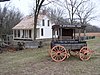 |
October 15, 1966 (#66000114) |
3 miles (4.8 km) south of Monument 36°59′07″N 94°21′18″W / 36.985278°N 94.355°W | Diamond | |
| 4 | Jolly Mill |  |
October 13, 1983 (#83004021) |
Southwest of Pierce City 36°53′50″N 94°04′18″W / 36.897222°N 94.071667°W | Pierce City | |
| 5 | Lentz-Carter Merchandise Store | 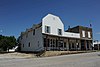 |
August 19, 2008 (#08000799) |
744 Ozark St. 36°45′38″N 94°11′32″W / 36.760608°N 94.192252°W | Stella | |
| 6 | Neosho Colored School |  |
April 17, 2017 (#100000887) |
639 Young St. 36°52′34″N 94°22′27″W / 36.876101°N 94.374227°W | Neosho | |
| 7 | Neosho Commercial Historic District |  |
August 12, 1993 (#93000722) |
Along sections of Main, Spring, Washington and Wood Sts.; also 114, 116, 118-120, 120, and 124-126 S. Wood St. 36°52′11″N 94°22′03″W / 36.869722°N 94.3675°W | Neosho | Second set of boundaries represents a boundary increase of April 18, 2007 |
| 8 | Neosho High School |  |
August 30, 2002 (#02000906) |
W. McCord and N. Wood Sts. 36°52′17″N 94°22′08″W / 36.871389°N 94.368889°W | Neosho | |
| 9 | Neosho Wholesale Grocery Company |  |
April 16, 2013 (#13000171) |
224 N. Washington St. 36°52′17″N 94°22′02″W / 36.871405°N 94.367291°W | Neosho | |
| 10 | Mathew H. Ritchey House |  |
December 5, 1978 (#78003399) |
Mill St. 36°52′39″N 94°10′58″W / 36.8775°N 94.182778°W | Newtonia | |
| 11 | Second Baptist Church | 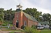 |
January 4, 1996 (#95001495) |
430 W. Grant St. 36°52′31″N 94°22′29″W / 36.875278°N 94.374722°W | Neosho | |
| 12 | Second Battle of Newtonia Site | December 23, 2004 (#04000698) |
Roughly an area northwest, southwest and southeast of the junction of Routes 86 and O at Newtonia 36°52′19″N 94°11′36″W / 36.871944°N 94.193333°W | Newtonia |
See also edit
References edit
Wikimedia Commons has media related to National Register of Historic Places in Newton County, Missouri.
- ^ The latitude and longitude information provided in this table was derived originally from the National Register Information System, which has been found to be fairly accurate for about 99% of listings. Some locations in this table may have been corrected to current GPS standards.
- ^ National Park Service, United States Department of the Interior, "National Register of Historic Places: Weekly List Actions", retrieved April 12, 2024.
- ^ Numbers represent an alphabetical ordering by significant words. Various colorings, defined here, differentiate National Historic Landmarks and historic districts from other NRHP buildings, structures, sites or objects.
- ^ The eight-digit number below each date is the number assigned to each location in the National Register Information System database, which can be viewed by clicking the number.