


Summary
This is a list of the National Register of Historic Places listings in Randolph County, Indiana.

This is intended to be a complete list of the properties and districts on the National Register of Historic Places in Randolph County, Indiana, United States. Latitude and longitude coordinates are provided for many National Register properties and districts; these locations may be seen together in a map.[1]
There are 14 properties and districts listed on the National Register in the county.
Properties and districts located in incorporated areas display the name of the municipality, while properties and districts in unincorporated areas display the name of their civil township. Properties and districts split between multiple jurisdictions display the names of all jurisdictions.
This National Park Service list is complete through NPS recent listings posted April 12, 2024.[2]
Current listings edit
| [3] | Name on the Register[4] | Image | Date listed[5] | Location | City or town | Description |
|---|---|---|---|---|---|---|
| 1 | Farmland Downtown Historic District |  |
September 8, 1994 (#94001124) |
Main St. from the alley south of Henry St. to William St. 40°11′27″N 85°07′42″W / 40.190833°N 85.128333°W | Farmland | |
| 2 | Fudge Site | 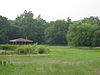 |
March 21, 2007 (#07000213) |
Immediately southwest of the confluence of Sugar Creek and the White River, northwest of Winchester[6] 40°11′08″N 84°59′27″W / 40.185556°N 84.990833°W | White River Township | |
| 3 | William Kerr House |  |
October 1, 1987 (#87001776) |
501 N. Columbia St. 40°12′08″N 84°48′33″W / 40.202222°N 84.809167°W | Union City | Designed by architect George Franklin Barber |
| 4 | Raphael Kirshbaum Building |  |
May 24, 1990 (#90000813) |
Northwestern corner of the junction of Columbia and W. Pearl Sts. 40°11′55″N 84°48′30″W / 40.198611°N 84.808333°W | Union City | |
| 5 | Randolph County Infirmary |  |
December 3, 2018 (#100003188) |
1882 S. U.S. Route 27 40°08′15″N 84°57′56″W / 40.1376°N 84.9655°W | White River Township | |
| 6 | Gen. Asahel Stone Mansion |  |
March 21, 1979 (#79000040) |
201 W. Orange St. 40°09′56″N 84°58′58″W / 40.165556°N 84.982778°W | Winchester | |
| 7 | Union City Commercial Historic District |  |
March 12, 1999 (#99000303) |
Roughly bounded by W. Oak, N. Union, W. Smith, and N. Howard Sts. 40°11′56″N 84°48′30″W / 40.198889°N 84.808333°W | Union City | |
| 8 | Union City Passenger Depot | 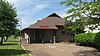 |
May 19, 1983 (#83000145) |
Howard St. 40°11′52″N 84°48′36″W / 40.197778°N 84.810000°W | Union City | |
| 9 | Union City Public Library |  |
June 22, 2004 (#04000631) |
408 N. Columbia St. 40°12′06″N 84°48′30″W / 40.201667°N 84.808333°W | Union City | |
| 10 | Union City School |  |
June 24, 2010 (#10000379) |
310 N. Walnut St. 40°11′58″N 84°48′49″W / 40.199444°N 84.813611°W | Union City | |
| 11 | Ward Township District No. 5 School |  |
June 12, 2017 (#100001064) |
Northwestern corner of E700N and N100E 40°16′00″N 84°57′27″W / 40.266667°N 84.957500°W | Ward Township | |
| 12 | Winchester Courthouse Square Historic District |  |
August 9, 2001 (#01000405) |
Roughly bounded by North St. and the alleys located to the east of Main St. 40°10′27″N 84°58′20″W / 40.174167°N 84.972222°W | Winchester | |
| 13 | Winchester Residential Historic District |  |
March 21, 2011 (#11000123) |
Roughly both sides of Washington and Franklin Sts. from Main St. to Greenville Ave. and both sides of Meridian and Main Sts. 40°10′20″N 84°58′44″W / 40.172222°N 84.978889°W | Winchester | |
| 14 | Windsor Mound | 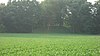 |
March 31, 2010 (#10000128) |
12102 W. Windsor Rd., south of Parker City 40°09′24″N 85°12′24″W / 40.156667°N 85.206667°W | Stoney Creek Township |
See also edit
References edit
- ^ The latitude and longitude information provided in this table was derived originally from the National Register Information System, which has been found to be fairly accurate for about 99% of listings. Some locations in this table may have been corrected to current GPS standards.
- ^ National Park Service, United States Department of the Interior, "National Register of Historic Places: Weekly List Actions", retrieved April 12, 2024.
- ^ Numbers represent an alphabetical ordering by significant words. Various colorings, defined here, differentiate National Historic Landmarks and historic districts from other NRHP buildings, structures, sites or objects.
- ^ "National Register Information System". National Register of Historic Places. National Park Service. March 13, 2009.
- ^ The eight-digit number below each date is the number assigned to each location in the National Register Information System database, which can be viewed by clicking the number.
- ^ Location derived from Otto, Martha P., and Brian G. Redmond, eds. Transitions: Archaic and Early Woodland Research in the Ohio Country. Athens: Ohio UP, 2008, 344-345. The NRIS lists the site as "Address Restricted".