
KNOWPIA
WELCOME TO KNOWPIA

National Register of Historic Places listings in Salem, Virginia 
Summary
This is a list of the National Register of Historic Places listings in Salem, Virginia.

This is intended to be a complete list of the properties and districts on the National Register of Historic Places in the independent city of Salem, Virginia, United States. The locations of National Register properties and districts for which the latitude and longitude coordinates are included below, may be seen in an online map.[1]
There are 19 properties and districts listed on the National Register in the city.
This National Park Service list is complete through NPS recent listings posted April 12, 2024.[2]
Current listings edit
| [3] | Name on the Register[4] | Image | Date listed[5] | Location | Description |
|---|---|---|---|---|---|
| 1 | Academy Street School | 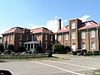 |
October 1, 1981 (#81000648) |
Academy St. 37°17′37″N 80°03′41″W / 37.293611°N 80.061389°W |
|
| 2 | Blair Apartments |  |
June 12, 2017 (#100001084) |
231 Chestnut St. 37°17′22″N 80°03′46″W / 37.289444°N 80.062778°W |
|
| 3 | Downtown Salem Historic District |  |
June 5, 1996 (#96000591) |
Roughly Main St. from Broad St. to College Ave. 37°17′35″N 80°03′24″W / 37.293056°N 80.056667°W |
|
| 4 | Evans House | 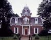 |
May 19, 1972 (#72001529) |
213 Broad St. 37°17′41″N 80°03′35″W / 37.294722°N 80.059722°W |
|
| 5 | Hart Motor Company | February 7, 2024 (#100009960) |
1341 E. Main Street 37°17′50″N 80°02′00″W / 37.2971°N 80.0334°W |
||
| 6 | Main Campus Complex, Roanoke College | 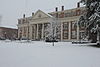 |
March 7, 1973 (#73002226) |
Roanoke College 37°17′45″N 80°03′20″W / 37.295833°N 80.055556°W |
|
| 7 | McVitty Home |  |
October 23, 2003 (#03001092) |
601 W. Main St. 37°17′30″N 80°04′02″W / 37.291528°N 80.067361°W |
|
| 8 | North Broad Street Historic District |  |
January 31, 2019 (#100003393) |
200-500 blocks of N. Broad St. 37°17′45″N 80°03′35″W / 37.295833°N 80.059722°W |
|
| 9 | Old Roanoke County Courthouse | 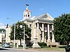 |
May 14, 1987 (#87000727) |
301 E. Main St. 37°17′38″N 80°03′16″W / 37.293889°N 80.054444°W |
|
| 10 | Peacock-Salem Launderers and Cleaners |  |
January 24, 2019 (#100003350) |
231 S. Colorado St. 37°17′27″N 80°03′20″W / 37.290833°N 80.055556°W |
|
| 11 | Preston House |  |
May 26, 2005 (#05000479) |
1936 W. Main St. 37°17′16″N 80°05′27″W / 37.287639°N 80.090833°W |
Acreage expanded at the same address in a boundary increase of May 3, 2006 |
| 12 | Roanoke Veterans Administration Hospital Historic District | 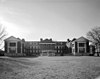 |
September 4, 2012 (#12000609) |
1970 Roanoke Boulevard 37°16′29″N 80°01′08″W / 37.274722°N 80.018889°W |
|
| 13 | Salem Post Office |  |
September 24, 1992 (#92001265) |
103 E. Main St. 37°17′36″N 80°03′24″W / 37.293333°N 80.056528°W |
|
| 14 | Salem Presbyterian Church | 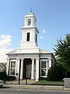 |
October 15, 1974 (#74002245) |
E. Main and Market Sts. 37°17′36″N 80°03′25″W / 37.293333°N 80.057083°W |
|
| 15 | Salem Presbyterian Parsonage |  |
January 28, 1992 (#91002017) |
530 E. Main St. 37°17′38″N 80°03′05″W / 37.293750°N 80.051389°W |
|
| 16 | Southwest Virginia Holiness Association Camp Meeting |  |
January 22, 1996 (#95001558) |
202 and 208 E. 3rd St. 37°17′16″N 80°03′15″W / 37.287778°N 80.054167°W |
|
| 17 | Valley Railroad Bridge |  |
August 12, 2009 (#09000617) |
1002 Newman Dr. 37°18′15″N 80°02′40″W / 37.304167°N 80.044444°W |
|
| 18 | Valleydale Packers Inc. |  |
January 31, 2019 (#100003394) |
710 E. 8th St. 37°16′57″N 80°02′44″W / 37.282500°N 80.045556°W |
|
| 19 | Williams-Brown House and Store | 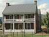 |
November 23, 1971 (#71001050) |
523 E. Main St. 37°17′41″N 80°02′52″W / 37.294722°N 80.047639°W |
Occupied by the Salem Museum and Historical Society |
See also edit
Wikimedia Commons has media related to National Register of Historic Places in Salem, Virginia.
References edit
- ^ The latitude and longitude information provided in this table was derived originally from the National Register Information System, which has been found to be fairly accurate for about 99% of listings. Some locations in this table may have been corrected to current GPS standards.
- ^ National Park Service, United States Department of the Interior, "National Register of Historic Places: Weekly List Actions", retrieved April 12, 2024.
- ^ Numbers represent an alphabetical ordering by significant words. Various colorings, defined here, differentiate National Historic Landmarks and historic districts from other NRHP buildings, structures, sites or objects.
- ^ "National Register Information System". National Register of Historic Places. National Park Service. April 24, 2008.
- ^ The eight-digit number below each date is the number assigned to each location in the National Register Information System database, which can be viewed by clicking the number.