
KNOWPIA
WELCOME TO KNOWPIA

National Register of Historic Places listings in Tripp County, South Dakota 
Summary
This is a list of the National Register of Historic Places listings in Tripp County, South Dakota.

This is intended to be a complete list of the properties on the National Register of Historic Places in Tripp County, South Dakota, United States. The locations of National Register properties for which the latitude and longitude coordinates are included below, may be seen in a map.[1]
There are 6 properties listed on the National Register in the county.
This National Park Service list is complete through NPS recent listings posted April 12, 2024.[2]
Current listings edit
| [3] | Name on the Register[4] | Image | Date listed[5] | Location | City or town | Description |
|---|---|---|---|---|---|---|
| 1 | E. G. Barnum House | 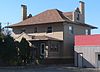 |
January 27, 1983 (#83003020) |
205 Van Buren 43°22′34″N 99°51′37″W / 43.376231°N 99.860232°W | Winner | |
| 2 | Lewis Bridge |  |
June 29, 1992 (#92000774) |
County road over the Keya Paha River, 13.6 miles northeast of Springview, Nebraska 42°59′53″N 99°38′08″W / 42.998056°N 99.635556°W | Wewela | Extends into Keya Paha County, Nebraska |
| 3 | Manthey Barn |  |
January 28, 2004 (#03001533) |
31952 289th St. 43°12′48″N 99°46′51″W / 43.213399°N 99.780816°W | Colome | |
| 4 | South Dakota Dept. of Transportation Bridge No. 62-220-512 |  |
December 9, 1993 (#93001321) |
Local road over the Keya Paha River 43°02′12″N 99°48′38″W / 43.036793°N 99.810693°W | Wewela | |
| 5 | Tripp County Veteran's Memorial |  |
November 17, 2009 (#09000947) |
200 E. 3rd St. 43°22′33″N 99°51′17″W / 43.375719°N 99.854621°W | Winner | |
| 6 | Wewela Hall |  |
November 29, 2010 (#10000952) |
Lots 3 and 4, Block 34, Government Townsite of Wewela 43°00′46″N 99°47′03″W / 43.01272°N 99.784092°W | Wewela |
See also edit
Wikimedia Commons has media related to National Register of Historic Places in Tripp County, South Dakota.
References edit
- ^ The latitude and longitude information provided in this table was derived originally from the National Register Information System, which has been found to be fairly accurate for about 99% of listings. Some locations in this table may have been corrected to current GPS standards.
- ^ National Park Service, United States Department of the Interior, "National Register of Historic Places: Weekly List Actions", retrieved April 12, 2024.
- ^ Numbers represent an alphabetical ordering by significant words. Various colorings, defined here, differentiate National Historic Landmarks and historic districts from other NRHP buildings, structures, sites or objects.
- ^ "National Register Information System". National Register of Historic Places. National Park Service. April 24, 2008.
- ^ The eight-digit number below each date is the number assigned to each location in the National Register Information System database, which can be viewed by clicking the number.