
KNOWPIA
WELCOME TO KNOWPIA

National Register of Historic Places listings in Washington Parish, Louisiana 
Summary
This is a list of the National Register of Historic Places listings in Washington Parish, Louisiana.

This is intended to be a complete list of the properties on the National Register of Historic Places in Washington Parish, Louisiana, United States. The locations of National Register properties for which the latitude and longitude coordinates are included below, may be seen in a map.[1]
There are 18 properties listed on the National Register in the parish.
This National Park Service list is complete through NPS recent listings posted April 12, 2024.[2]
Current listings edit
| [3] | Name on the Register[4] | Image | Date listed[5] | Location | City or town | Description |
|---|---|---|---|---|---|---|
| 1 | Robert H. Babington House | December 6, 1979 (#79001097) |
608 Main St. 30°50′55″N 90°09′27″W / 30.848611°N 90.1575°W | Franklinton | ||
| 2 | Thomas M. Babington House |  |
July 21, 1995 (#95000899) |
828 Main St. 30°50′45″N 90°09′28″W / 30.845833°N 90.157778°W | Franklinton | |
| 3 | Bogalusa City Hall |  |
July 26, 1979 (#79001095) |
214 Arkans Hall Ave. 30°47′09″N 89°51′36″W / 30.785833°N 89.86°W | Bogalusa | |
| 4 | Bogalusa Coca Cola Bottling Plant |  |
May 21, 2019 (#100003379) |
213 Shenandoah St. 30°47′20″N 89°51′53″W / 30.7889°N 89.8648°W | Bogalusa | |
| 5 | Bogalusa Railroad Station | 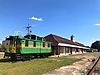 |
May 1, 1980 (#80001767) |
400 Austin St. 30°47′24″N 89°51′38″W / 30.79°N 89.860556°W | Bogalusa | |
| 6 | Brumfield Homestead | September 24, 2014 (#14000693) |
47082 T.C. Brumfield Rd. 30°54′35″N 90°06′33″W / 30.9097°N 90.1092°W | Franklinton vicinity | ||
| 7 | Franklinton High School |  |
August 6, 1998 (#98000988) |
617 Main St. 30°50′58″N 90°09′29″W / 30.849444°N 90.158056°W | Franklinton | |
| 8 | Greenlaw House |  |
August 6, 1998 (#98000987) |
613 10th Ave. 30°51′00″N 90°09′26″W / 30.85°N 90.157222°W | Franklinton | |
| 9 | Robert "Bob" Hicks House |  |
January 20, 2015 (#14001174) |
924 E. Robert "Bob" Hicks (formerly 9th) St. 30°46′15″N 89°50′48″W / 30.7708°N 89.8468°W | Bogalusa | Home of a prominent local Civil Rights leader of the 1960s. |
| 10 | Knight Cabin |  |
January 23, 1979 (#79001098) |
Washington Parish Fairgrounds 30°51′18″N 90°09′59″W / 30.855°N 90.166389°W | Franklinton | |
| 11 | Nehemiah Magee House | August 12, 1982 (#82002802) |
Southwest of Mt. Hermon 30°56′35″N 90°19′53″W / 30.943056°N 90.331389°W | Mount Hermon vicinity | ||
| 12 | Robert D. Magee House | August 11, 1982 (#82002801) |
West of Angie off Louisiana Highway 438 30°59′02″N 89°55′59″W / 30.983889°N 89.933056°W | Angie vicinity | ||
| 13 | Bouey Moore Homestead | December 8, 2009 (#09001059) |
19068 Moore Rd. 30°47′48″N 89°59′32″W / 30.796642°N 89.992322°W | Franklinton | ||
| 14 | Sullivan House |  |
July 27, 1979 (#79001096) |
223 S. Border Dr. 30°46′48″N 89°52′08″W / 30.78°N 89.868889°W | Bogalusa | |
| 15 | Sylvest House |  |
January 23, 1979 (#79001099) |
Washington Parish Fairgrounds 30°51′18″N 90°09′58″W / 30.855°N 90.166111°W | Franklinton | |
| 16 | US Post Office | 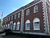 |
January 27, 1983 (#83000552) |
305 Avenue B 30°46′43″N 89°52′00″W / 30.778611°N 89.866667°W | Bogalusa | |
| 17 | D.A. Varnado and Son Store |  |
July 25, 2001 (#01000763) |
936 Pearl St. 30°50′38″N 90°09′15″W / 30.843889°N 90.154167°W | Franklinton | |
| 18 | Warren House | December 4, 1998 (#98001442) |
29296 Louisiana Highway 25, N. 30°57′02″N 90°10′39″W / 30.950556°N 90.1775°W | Franklinton vicinity |
See also edit
Wikimedia Commons has media related to National Register of Historic Places in Washington Parish, Louisiana.
References edit
- ^ The latitude and longitude information provided in this table was derived originally from the National Register Information System, which has been found to be fairly accurate for about 99% of listings. Some locations in this table may have been corrected to current GPS standards.
- ^ National Park Service, United States Department of the Interior, "National Register of Historic Places: Weekly List Actions", retrieved April 12, 2024.
- ^ Numbers represent an alphabetical ordering by significant words. Various colorings, defined here, differentiate National Historic Landmarks and historic districts from other NRHP buildings, structures, sites or objects.
- ^ "National Register Information System". National Register of Historic Places. National Park Service. March 13, 2009.
- ^ The eight-digit number below each date is the number assigned to each location in the National Register Information System database, which can be viewed by clicking the number.