


Summary
Needle Hill or Cham Shan (Chinese: 針山) is a mountain in New Territories, Hong Kong. It has an altitude of 532 m.[1] This is a part of a popular hiking route including Grassy Hill and Tai Mo Shan. The mountain got its name due to the resemblance of a needle by its peak.
| Needle Hill, Hong Kong | |
|---|---|
| 針山 | |
 Stage 7 of the MacLehose Trail near the summit of Needle Hill in December 2006 | |
| Highest point | |
| Elevation | 532 m (1,745 ft) Hong Kong Principal Datum |
| Coordinates | 22°23′14″N 114°09′38″E / 22.387089°N 114.160486°E |
| Geography | |
 Needle Hill, Hong Kong Location of Needle Hill in Hong Kong | |
| Location | |
| Needle Hill | |||||||||||||||||
|---|---|---|---|---|---|---|---|---|---|---|---|---|---|---|---|---|---|
| Traditional Chinese | 針山 | ||||||||||||||||
| Simplified Chinese | 针山 | ||||||||||||||||
| Literal meaning | Needle Mountain | ||||||||||||||||
| |||||||||||||||||

Geography edit
At around 400 above sea level, it forms a needle-like shape at its peak. The granitic rocks that form this hill is part of a granitic ridge that starts at the Tolo Channel and ends in Kwai Chung.[2]
Needle Hill is located within Shing Mun Country Park.[3] Stage 7 of the MacLehose Trail includes the summit of Needle Hill.[4] The Shing Mun Tunnels pass through the base of Needle Hill. The Lower Shing Mun River can also be found at the base of the hill.
Geology edit
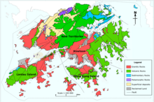
Needle Hill is mainly composed of Granite. Wolframite, Molybdenite and Quartz ores can be found at the base of the hill.[2]
History edit
Wolframite, a tungsten ore, was discovered at Needle Hill in 1935. It was mined there from 1938 to 1967.[5][6] The mines used to obtain Wolframite ores are now abandoned.[2]
See also edit
References edit
- ^ Lands Department (February 2014), Hong Kong Geographic Data (PDF), retrieved 2014-09-12
- ^ a b c Agriculture, Fisheries and Conservation Department (2006-10-17). Central Ridge and West (in English and Chinese). Hong Kong: Cosmos Books Limited. p. 59. ISBN 9882113273.
- ^ AFCD: Shing Mun Country Park
- ^ AFCD: MacLehose Trail Section 7: Shing Mun to Lead Mine Pass
- ^ CEDD: Economic Geology - Metalliferous minerals Archived 2013-12-19 at the Wayback Machine
- ^ Roberts, KJ; Strange, PJ (September 1991). "The geology and exploitation of the Needle Hill wolframite deposit" (PDF). Geological Society of Hong Kong Newsletter. Vol. 9, no. 3. Hong Kong. pp. 29–40.
External links edit
- Needle Hill Tungsten Mine at industrialhistoryhk.org
- Needle Hill Tungsten Mine at gwulo.com
22°23′14″N 114°09′38″E / 22.387089°N 114.160486°E