


Summary
Omkoi (Thai: อมก๋อย, pronounced [ʔōm.kɔ̌j]) is the southwesternmost district (amphoe) of Chiang Mai province in northern Thailand.
Omkoi
อมก๋อย | |
|---|---|
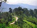
 Lahu farmers in the mountains of Omkoi | |
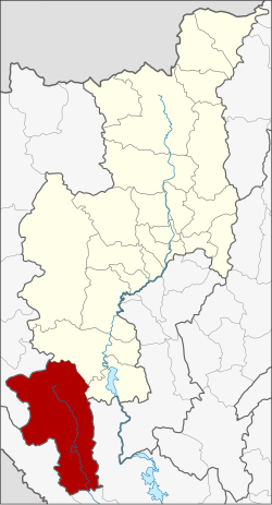 District location in Chiang Mai province | |
| Coordinates: 17°48′4″N 98°21′31″E / 17.80111°N 98.35861°E | |
| Country | Thailand |
| Province | Chiang Mai |
| Area | |
| • Total | 2,093.8 km2 (808.4 sq mi) |
| Population (2005) | |
| • Total | 54,568 |
| • Density | 26.1/km2 (68/sq mi) |
| Time zone | UTC+7 (ICT) |
| Postal code | 50310 |
| Geocode | 5018 |
Geography edit
Neighboring districts are (from the north clockwise) Hot and Doi Tao of Chiang Mai Province, Sam Ngao, Mae Ramat, and Tha Song Yang of Tak province and Sop Moei of Mae Hong Son province. The Thanon Thongchai Range dominates the landscape.
History edit
The minor district (king amphoe) was established on 19 April 1929 as a subordinate of Hot district, consisting of the three sub-districts Omkoi, Yang Piang, and Mae Tuen.[1] It was upgraded to a full district on 23 July 1958.[2]
Administration edit
The district is divided into six sub-districts (tambon), which are further subdivided into 95 villages (muban). Omkoi is a sub-district municipality (thesaban tambon) which covers parts of the tambon Omkoi. There are further six tambon administrative organizations (TAO).
| No. | Name | Thai name | Villages | Pop. | |
|---|---|---|---|---|---|
| 1. | Omkoi | อมก๋อย | 20 | 17,208 | |
| 2. | Yang Piang | ยางเปียง | 17 | 7,990 | |
| 3. | Mae Tuen | แม่ตื่น | 16 | 9,180 | |
| 4. | Mon Chong | ม่อนจอง | 9 | 6,008 | |
| 5. | Mae Long[3] | แม่หลอง | 12 | 6,285 | |
| 6. | Na Kian | นาเกียน | 21 | 7,897 |
Gallery edit
-
 Rte 1099 ends in the jungle at Mae Thun Noi, Omkoi

References edit
- ^ แจ้งความกระทรวงมหาดไทย เรื่อง ตั้งกิ่งอำเภอ (PDF). Royal Gazette (in Thai). 46 (ง): 296–297. 28 April 1929. Archived from the original (PDF) on 24 May 2012.
- ^ พระราชกฤษฎีกาจัดตั้งอำเภอกระสัง อำเภอกระนวน อำเภอบางกอกใหญ่ อำเภอขุนหาร อำเภอพนา อำเภอปากช่อง อำเภอวังเหนือ อำเภอวังชิ้น อำเภอแม่ทา อำเภอหนองหมู อำเภอสระแก้ว อำเภออมก๋อย อำเภอบางซ้าย อำเภอทับสะแก อำเภอบุณฑริก อำเภอลานสะกา อำเภอจอมบึง อำเภอท่ายาง อำเภอสามเงา อำเภอฟากท่า อำเภอบ้านเขว้า อำเภอชานุมาน อำเภอแม่พริก อำเภอท่าสองยาง อำเภอสะเมิง อำเภอหนองแขม อำเภอพระแสง พ.ศ. ๒๕๐๑ (PDF). Royal Gazette (in Thai). 75 (55 ก): 321–327. 22 July 1958. Archived from the original (PDF) on 6 April 2012.
- ^ ประกาศกระทรวงมหาดไทย เรื่อง เปลี่ยนแปลงชื่อตำบลสบโขง อำเภออมก๋อย จังหวัดเชียงใหม่ เป็นชื่อตำบลแม่หลอง ประกาศ ณ วันที่ 7 มีนาคม 2565
External links edit
- amphoe.com (Thai)