
KNOWPIA
WELCOME TO KNOWPIA

Oshamambe, Hokkaido 
Summary
Oshamambe (長万部町, Oshamambe-chō) is a town located in Oshima Subprefecture, Hokkaido, Japan.
Oshamambe
長万部町 | |
|---|---|
Town | |
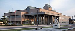 Oshamanbe Town Hall | |
 Flag  Seal | |
 Location of Oshamambe in Hokkaido (Oshima Subprefecture) | |
 Oshamambe Location in Japan | |
| Coordinates: 42°30′29″N 140°22′23″E / 42.50806°N 140.37306°E | |
| Country | Japan |
| Region | Hokkaido |
| Prefecture | Hokkaido (Oshima Subprefecture) |
| District | Yamakoshi |
| Government | |
| • Mayor | Masashi Kihata |
| Area | |
| • Total | 310.75 km2 (119.98 sq mi) |
| Population (30 September 2016) | |
| • Total | 5,694 |
| • Density | 18/km2 (47/sq mi) |
| Time zone | UTC+09:00 (JST) |
| City hall address | 453-1 Oshamambe, Oshamambe, Yamakoshi District, Hokkaido 049-3592 |
| Climate | Dfb |
| Website | www |
| Symbols | |
| Flower | Iris sanguinea |
| Tree | Pinus thunbergii |
As of 30 October 2016, the town has an estimated population of 5,694. The total land area is 310.75 km2.
Geography edit
Oshamambe faces Uchiura Bay, which is a bay of the Pacific Ocean.
Neighboring municipalities edit
- Oshima Subprefecture
- Hiyama Subprefecture
- Shiribeshi Subprefecture
- Iburi Subprefecture
Climate edit
| Climate data for Oshamambe, Hokkaido (1991−2020 normals, extremes 1977−present) | |||||||||||||
|---|---|---|---|---|---|---|---|---|---|---|---|---|---|
| Month | Jan | Feb | Mar | Apr | May | Jun | Jul | Aug | Sep | Oct | Nov | Dec | Year |
| Record high °C (°F) | 8.1 (46.6) |
9.1 (48.4) |
16.0 (60.8) |
23.8 (74.8) |
29.3 (84.7) |
29.9 (85.8) |
32.6 (90.7) |
32.0 (89.6) |
30.8 (87.4) |
25.4 (77.7) |
20.4 (68.7) |
13.3 (55.9) |
32.6 (90.7) |
| Mean daily maximum °C (°F) | −0.2 (31.6) |
0.4 (32.7) |
4.0 (39.2) |
9.9 (49.8) |
14.9 (58.8) |
18.3 (64.9) |
22.1 (71.8) |
24.2 (75.6) |
22.0 (71.6) |
16.1 (61.0) |
8.7 (47.7) |
2.0 (35.6) |
11.9 (53.4) |
| Daily mean °C (°F) | −4.1 (24.6) |
−3.6 (25.5) |
0.0 (32.0) |
5.2 (41.4) |
10.2 (50.4) |
14.5 (58.1) |
18.7 (65.7) |
20.6 (69.1) |
17.2 (63.0) |
10.7 (51.3) |
4.1 (39.4) |
−1.9 (28.6) |
7.6 (45.8) |
| Mean daily minimum °C (°F) | −8.7 (16.3) |
−8.6 (16.5) |
−4.6 (23.7) |
0.3 (32.5) |
5.6 (42.1) |
11.1 (52.0) |
15.9 (60.6) |
17.4 (63.3) |
12.6 (54.7) |
5.4 (41.7) |
−0.5 (31.1) |
−6.1 (21.0) |
3.3 (38.0) |
| Record low °C (°F) | −20.5 (−4.9) |
−20.4 (−4.7) |
−16.6 (2.1) |
−9.7 (14.5) |
−2.1 (28.2) |
2.7 (36.9) |
5.2 (41.4) |
7.4 (45.3) |
2.2 (36.0) |
−3.0 (26.6) |
−10.4 (13.3) |
−18.9 (−2.0) |
−20.5 (−4.9) |
| Average precipitation mm (inches) | 73.2 (2.88) |
73.3 (2.89) |
64.3 (2.53) |
82.2 (3.24) |
104.7 (4.12) |
98.4 (3.87) |
148.1 (5.83) |
176.2 (6.94) |
164.5 (6.48) |
114.6 (4.51) |
108.0 (4.25) |
88.8 (3.50) |
1,296.1 (51.03) |
| Average snowfall cm (inches) | 174 (69) |
164 (65) |
104 (41) |
9 (3.5) |
0 (0) |
0 (0) |
0 (0) |
0 (0) |
0 (0) |
0 (0) |
24 (9.4) |
128 (50) |
600 (236) |
| Average rainy days | 16.9 | 16.0 | 13.6 | 11.0 | 10.2 | 9.5 | 11.1 | 11.3 | 11.6 | 13.2 | 15.3 | 16.5 | 156.2 |
| Average snowy days | 21.6 | 20.4 | 15.0 | 1.4 | 0 | 0 | 0 | 0 | 0 | 0 | 3.0 | 15.7 | 77.1 |
| Mean monthly sunshine hours | 98.0 | 95.7 | 141.6 | 174.3 | 179.8 | 135.2 | 113.5 | 131.9 | 156.8 | 151.2 | 106.0 | 94.5 | 1,578.5 |
| Source 1: JMA[1] | |||||||||||||
| Source 2: JMA[2] | |||||||||||||
History edit
- 1864: The village of Oshamambe was founded.[3]
- 1906: Oshamambe became a Second Class Village.
- 1923: Oshamambe became a First Class Village.
- 1943: Oshamambe village became Oshamambe town.
Education edit
University edit
- Tokyo University of Science, Oshamambe Campus
High school edit
- Hokkaido Oshamambe High School
Junior high school edit
- Oshamambe Junior High School
Elementary schools edit
- Oshamambe Elementary School
- Shizukari Elementary School
Transportation edit
Railway edit
Setana Line ran from Kunnui Station. There used to be Asahihama station between Oshamambe Station and Shizukari Station.
- Hakodate Main Line: Kita-Toyotsu - Kunnui - Oshamambe - Futamata
- Muroran Main Line: Oshamambe - Shizukari
Highway edit
 Hokkaido Expressway: Shizukari PA - Oshamambe IC - Kunnui IC
 National Route 5
 National Route 37
 National Route 230
Plans are in place to build a station at Oshamambe and construction is underway on the Hokkaido Shinkansen line. The section between Hakodate and Sapporo should be completed by 2030.
References edit
External links edit
 Media related to Oshamambe, Hokkaido at Wikimedia Commons
- Official Website (in Japanese)