


Summary
Pearson Reef (Filipino: Bahura ng Hizon), as known as Phan Vinh Island (Vietnamese: Đảo Phan Vinh); Mandarin Chinese: 毕生礁; pinyin: Bìshēng jiāo, is a atoll on the Spratly Islands in the South China Sea. The atoll has been occupied by Vietnam since 1978. It is also claimed by China (PRC), the Philippines, Vietnam, and Taiwan (ROC).[1][2][3]
| Disputed atoll | |
|---|---|
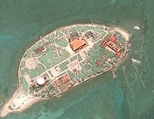
 Pearson Reef in 2022 | |
 Pearson Reef | |
| Other names | Đảo Phan Vinh (Vietnamese) Hizon Reef (Philippine English) Bahura ng Hizon (Filipino) 毕生礁 Bìshēng jiāo (Chinese) |
| Geography | |
| Location | South China Sea |
| Coordinates | 8°58′31″N 113°42′31″E / 8.97528°N 113.70861°E |
| Archipelago | Spratly Islands |
| Total islands | 2 |
| Major islands | Phan Vinh Island Phan Vinh B Islet |
| Administration | |
| District | Trường Sa District |
| Township | Trường Sa Township |
| Claimed by | |
Characteristic edit

Pearson Reef is about 9 km long and about 1.8 km wide and in the middle there is an enclosed lagoon 3 to 6 m deep. The total area of this coral reef is 14.75 km2, of which the area of the reef is 2.72 km2.[4]
To the northeast of Pearson Reef is a floating island, named Phan Vinh Island (đảo Phan Vinh), formerly known as Hon Sap Island (Đảo Hòn Sập) in Vietnam. The island has an annular shape.[5] It has a length of 290 m, a width of 140 m and lies on a 4.9 nautical mile (9.1 km) long coral reef that also follows the northeast-southwest axis. The island has a natural area of about 2.4 hectares. The island belongs to the Spratly cluster (cụm Trường Sa) of the Spratly Island and is located about 14.5 nautical miles (27 km) northwest of Alison Reef (Toc Tan Reef, đá Tốc Tan). In October 2021, Vietnam started dredging and expanding the accretion at 3 features: Phan Vinh Island, Namyit Island and Sand Cay Island.[6] According to images taken by the Sentinel-2 satellite (ESA), by June 2023, Phan Vinh Island has been expanded with an area of about 50 hectares of floating land, 1.6 km long and 600m wide with a lock in the middle of the island.
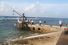
There is also a concrete structure called Phan Vinh B Islet (đảo chìm Phan Vinh B) located to the west about 3.3 nautical miles (6.1 km) west-southwest of Phan Vinh Island, with coordinates 8°57′33″N 113°39′12″E. On Phan Vinh B Islet, there are 3 durable houses (built many years ago) that are linked together by a wide concrete road and have a helipad for helicopters to take off and land in case of rescue missions.[7]
Environment and infrastructure edit
Phan Vinh Island does not have a fresh water source, but there are some green trees such as putat, beach casuarina, bayhops, portia tree, banyan, etc.[8]
On Phan Vinh Island, there are ways of civil works such as wind and solar power systems,[9] cultural houses, clinics, etc.
There is a religious establishment on the island, Vinh Phuc Pagoda (chùa Vinh Phúc).[10]
Vietnam has built Radar Station 44 (T44) on Phan Vinh Island, which can be observed within a radius of 300 km of the entire Spratly Islands in the South China Sea.[11]
History edit
Pearson Reef was first observed by Pearson, commander of the Bahamian, in 1843.[12]
Before 1978, Phan Vinh Island was named Hon Sap Island by Vietnam. At the beginning of 1978, the situation in the Spratly Islands was complicated, the Philippines sent troops to occupy An Nhon reef (formerly known as Lan Can reef), some countries sent many ships to the Truong Sa archipelago. Sa. The Vietnamese Navy decided to quickly organize forces to keep the islands of Central London Reef, Sin Cowe East Island, Phan Vinh Island and Amboyna Cay.[13]
On March 30, 1978, a detachment of 31 people from Regiment 146, Naval Region 4, commanded by Second Lieutenant Vũ Xuân Hà, accompanied by Regiment Commander Cao Ánh Đăng aboard ship 680 of Division 128 was stationed Phan Vinh Island.
"Phan Vinh Island" as Vietnamese call it, comes from the name of the Hero of the People's Armed Forces, Lieutenant Nguyễn Phan Vinh (1933 – 1968, native of Dien Ban, Quang Nam), who was the captain of many numberless ship in the Vietnam War.
See also edit
References edit
- ^ (in Vietnamese)An sinh xã hội (June 20, 2017). "Chuyện người lính giữ đảo Phan Vinh". Retrieved November 9, 2022.
- ^ D. J. Hancox; John Robert Victor Prescott (1995). A Geographical Description of the Spratly Islands and an Account of Hydrographic Surveys Amongst Those Islands. IBRU. pp. 13–. ISBN 978-1-897643-18-1.
- ^ "Pearson Reef". cil.nus.edu.sg. Retrieved 24 November 2022.
- ^ "Pearson Reef". cil.nus.edu.sg. Retrieved 2022-10-13.
- ^ Sailing Directions 161 (Enroute) - South China Sea and the Gulf of Thailand (13 ed.). Bethesda, Maryland: National Geospatial-Intelligence Agency. 2011. p. 12.
- ^ "Castles Made of Sand: Vietnam's Spratly Upgrades". Asia Maritime Transparency Initiative. Retrieved 2022-08-24.
- ^ "Vững chãi đảo chìm Phan Vinh B". Báo Thanh Niên (in Vietnamese). 2020-06-08. Retrieved 2022-09-10.
- ^ "Mầm xanh mới - tình yêu đất liền gửi đảo Phan Vinh". Tuổi Trẻ Online. 2017-05-28.
- ^ "Năng lượng sạch trên đảo Phan Vinh". vietnam.vnanet.vn (in Vietnamese). 2021-11-04. Retrieved 2022-09-07.
- ^ "Chùa Vinh Phúc – Cột mốc tâm linh giữa Biển Đông". vietnam.vnanet.vn (in Vietnamese). 2020-03-02. Retrieved 2022-09-08.
- ^ ""Mắt thần" trên Biển Đông". vietnam.vnanet.vn (in Vietnamese). 2020-01-26. Retrieved 2022-09-07.
- ^ Findlay, Alexander George (1878). A Directory for the Navigation of the Indian Archipelago, China, and Japan. Richard Holmes Laurie. p. 663.
- ^ "Chuyện người lính giữ đảo Phan Vinh". baodansinh.vn. Retrieved 2022-11-09.
External links edit
- Maritime Transparency Initiative Island Tracker