


Summary
The Penny Ice Cap, formerly Penny Icecap,[1] is a 6,000 km2 (2,300 sq mi) ice cap in Auyuittuq National Park of Baffin Island, Nunavut, Canada. It forms a 2,000 m (6,562 ft) high barrier on the Cumberland Peninsula, an area of deep fjords and glaciated valleys. It is a remnant of the last ice age. During the mid-1990s, Canadian researchers studied the glacier's patterns of freezing and thawing over centuries by drilling ice core samples.[2][3]
| Penny Ice Cap | |
|---|---|
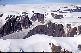 The Penny Ice Cap | |
 | |
| Type | Ice cap |
| Location | Nunavut, Canada |
| Coordinates | 67°17′N 66°13′W / 67.283°N 66.217°W |
| Terminus | outflow glaciers |
The ice cap has been thinning and its valley glaciers have been retreating in recent decades related to rising summer and winter air temperatures across the eastern Arctic.[4][5]
The ice cap is named after Captain William Penny, a whaling captain from Aberdeen in Scotland who pioneered over-wintering with native Inuit at Cumberland Sound in order to be able to start whaling (in the 19th century) much earlier in the season. He was also engaged by Lady Franklin to search for John Franklin, lost with all his crew in the search for the Northwest Passage.
See also edit
References edit
- ^ Penny Ice Cap (Formerly Penny Icecap)
- ^ "Nunatsiaq News: Penney Ice Cap shrinking like the rest?". Archived from the original on 2008-05-12. Retrieved 2008-01-05.
- ^ NOAA Paleoclimatology: Penny Ice Cap Data
- ^ NASA: Penny Ice Cap in 1979 and 2000
- ^ C. Zdanowicz et al.: Summer melt rates on Penny Ice Cap, Baffin Island: Past and recent trends, and implications for regional climate