
KNOWPIA
WELCOME TO KNOWPIA

Perry Township, Monroe County, Indiana 
Summary
Perry Township is one of eleven townships in Monroe County, Indiana, United States. As of the 2010 census, its population was 50,673 and it contained 24,194 housing units.[3]
Perry Township | |
|---|---|
 Field in Perry Township | |
 Location in Monroe County | |
| Coordinates: 39°07′21″N 86°31′08″W / 39.12250°N 86.51889°W | |
| Country | |
| State | |
| County | Monroe |
| Government | |
| • Type | Indiana township |
| Area | |
| • Total | 35.48 sq mi (91.9 km2) |
| • Land | 35.36 sq mi (91.6 km2) |
| • Water | 0.12 sq mi (0.3 km2) 0.34% |
| Elevation | 728 ft (222 m) |
| Population | |
| • Total | 52,807 |
| • Density | 1,433.2/sq mi (553.4/km2) |
| Time zone | UTC-5 (Eastern (EST)) |
| • Summer (DST) | UTC-4 (EDT) |
| ZIP codes | 47401, 47403, 47404 |
| Area code(s) | 812, 930 |
| GNIS feature ID | 453723 |
History edit
Perry Township was established in 1830.[4] It was named for Commodore Oliver Hazard Perry.[5]
Geography edit
According to the 2010 census, the township has a total area of 35.48 square miles (91.9 km2), of which 35.36 square miles (91.6 km2) (or 99.66%) is land and 0.12 square miles (0.31 km2) (or 0.34%) is water.[3]
Cities, towns, villages edit
- Bloomington (southern half of the city, south of [approximately] Third Street)
Unincorporated towns edit
- Broadview at 39°08′23″N 86°32′18″W / 39.13977°N 86.538330°W
- Clear Creek at 39°06′33″N 86°32′24″W / 39.109214°N 86.539997°W
- Handy at 39°05′45″N 86°29′38″W / 39.095881°N 86.493884°W
- Hoosier Acres at 39°09′28″N 86°29′13″W / 39.157825°N 86.48694°W
- Ridgemede at 39°09′07″N 86°30′11″W / 39.151992°N 86.503052°W
- Sanders at 39°04′47″N 86°30′48″W / 39.079770°N 86.513329°W
- Sunny Slopes at 39°07′55″N 86°31′52″W / 39.131992°N 86.531108°W
(This list is based on USGS data and may include former settlements.)
Cemeteries edit
The township contains Mount Salem Cemetery.
Major highways edit
School districts edit
- Monroe County Community School Corporation
Political districts edit
- Indiana's 9th congressional district
- State House District 60
- State House District 61
- State Senate District 40
Gallery edit
-
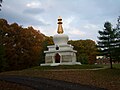 Kalacakra Stupa, Tibetan Mongolian Buddhist Cultural Center
 -
 All Saints' Orthodox Church on a winter day
 -
 A county road crossing Clear Creek
 -
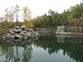 An old limestone quarry


References edit
- "Perry Township, Monroe County, Indiana". Geographic Names Information System. United States Geological Survey, United States Department of the Interior. Retrieved September 27, 2009.
- United States Census Bureau 2008 TIGER/Line Shapefiles
- IndianaMap
- ^ "US Board on Geographic Names". United States Geological Survey. October 25, 2007. Retrieved May 9, 2017.
- ^ "Census Bureau profile: Perry Township, Monroe County, Indiana". United States Census Bureau. May 2023. Retrieved March 21, 2024.
- ^ a b "Population, Housing Units, Area, and Density: 2010 - County -- County Subdivision and Place -- 2010 Census Summary File 1". United States Census. Archived from the original on February 12, 2020. Retrieved May 10, 2013.
- ^ Blanchard, Charles (1884). Counties of Morgan, Monroe and Brown, Indiana: Historical and Biographical. F.A. Battey & Company. pp. 381.
- ^ History of Lawrence and Monroe Counties, Indiana: Their People, Industries, and Institutions. B.F. Bowen. 1914. pp. 417.
External links edit
- Indiana Township Association
- United Township Association of Indiana
- City-Data.com page for Perry Township