
KNOWPIA
WELCOME TO KNOWPIA

Pic Verdaguer 
Summary
Pic Verdaguer or Pic de Verdaguer is a mountain of the Montcalm Massif. Located in the Pyrenees, at the border between France and Spain, it has an altitude of 3,129 metres (10,266 ft) above sea level.[2]
| Pic Verdaguer | |
|---|---|
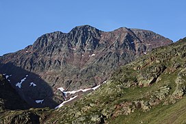 Pic Verdaguer (left), Pica d'Estats (middle), Punta Gabarró (right) | |
| Highest point | |
| Elevation | 3,129 m (10,266 ft)[1] |
| Prominence | 29 m (95 ft) |
| Parent peak | Pica d'Estats (3143 m) |
| Isolation | 149 m (489 ft) |
| Listing | |
| Coordinates | 42°40′5.02″N 1°23′48.98″E / 42.6680611°N 1.3969389°E |
| Geography | |
 Pic Verdaguer Location in the Pyrenees | |
| Location | Ariège, France Pallars Sobirà, Spain |
| Protected area | Alt Pirineu Natural Park |
| Parent range | Montcalm Massif, Pyrenees |
| Geology | |
| Mountain type | Granite |
| Climbing | |
| First ascent | Unknown |
| Easiest route | From Vallferrera, Alins |
This mountain is included in the Alt Pirineu Natural Park together with Pica d'Estats and Punta Gabarró.
References edit
External links edit
 Media related to Pic Verdaguer at Wikimedia Commons
- Pica d'Estats route through Canalbona. Includes Pic Verdaguer