
KNOWPIA
WELCOME TO KNOWPIA

Rankoshi, Hokkaido 
Summary
Rankoshi (蘭越町, Rankoshi-chō) is a town located in Shiribeshi Subprefecture, Hokkaido, Japan.
Rankoshi
蘭越町 | |
|---|---|
Town | |
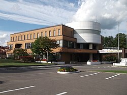 Rankoshi Town Office | |
 Flag  Seal | |
 Location of Rankoshi in Hokkaido (Shiribeshi Subprefecture) | |
 Rankoshi Location in Japan | |
| Coordinates: 42°49′N 140°32′E / 42.817°N 140.533°E | |
| Country | Japan |
| Region | Hokkaido |
| Prefecture | Hokkaido (Shiribeshi Subprefecture) |
| District | Isoya |
| Government | |
| • Mayor | Tomeo Miyauchi |
| Area | |
| • Total | 449.68 km2 (173.62 sq mi) |
| Population (September 30, 2016) | |
| • Total | 4,893 |
| • Density | 11/km2 (28/sq mi) |
| Time zone | UTC+09:00 (JST) |
| City hall address | 258-5 Rankoshicho, Rankoshi, Isoya-gun, Hokkaido 048-1392 |
| Climate | Dfb |
| Website | www |
| Symbols | |
| Flower | Magnolia kobus |
| Mascot | Love-chan (らぶちゃん) |
| Tree | Magnolia kobus |
As of September 2016, the town has an estimated population of 4,893, and a density of 11 persons per km2. The total area is 449.68 km2.
Geography edit
Shiribetsu River flows through Rankoshi to the Sea of Japan. The town is surrounded by Niseko Volcanic Group, which belongs to Niseko-Shakotan-Otaru Kaigan Quasi-National Park.
The name is derived from Ainu word "Ranko-usi", meaning "Place with many Katsura trees".[1]
- Mountains: Mount Raiden, Mount Mekunnai, Mount Chisenupuri, Mount Nitonupuri
Neighboring towns edit
- Shiribeshi Subprefecture
- Iburi Subprefecture
Climate edit
| Climate data for Rankoshi (1991−2020 normals, extremes 1977−present) | |||||||||||||
|---|---|---|---|---|---|---|---|---|---|---|---|---|---|
| Month | Jan | Feb | Mar | Apr | May | Jun | Jul | Aug | Sep | Oct | Nov | Dec | Year |
| Record high °C (°F) | 8.7 (47.7) |
9.7 (49.5) |
15.0 (59.0) |
25.2 (77.4) |
33.1 (91.6) |
32.7 (90.9) |
33.7 (92.7) |
35.4 (95.7) |
32.1 (89.8) |
25.9 (78.6) |
20.7 (69.3) |
13.6 (56.5) |
35.4 (95.7) |
| Mean daily maximum °C (°F) | −0.8 (30.6) |
0.0 (32.0) |
3.9 (39.0) |
10.6 (51.1) |
17.3 (63.1) |
21.3 (70.3) |
24.7 (76.5) |
25.9 (78.6) |
22.4 (72.3) |
15.8 (60.4) |
7.9 (46.2) |
1.2 (34.2) |
12.5 (54.5) |
| Daily mean °C (°F) | −4.2 (24.4) |
−3.7 (25.3) |
−0.2 (31.6) |
5.4 (41.7) |
11.4 (52.5) |
15.9 (60.6) |
19.9 (67.8) |
20.9 (69.6) |
16.8 (62.2) |
10.1 (50.2) |
3.6 (38.5) |
−2.1 (28.2) |
7.8 (46.1) |
| Mean daily minimum °C (°F) | −8.2 (17.2) |
−8.1 (17.4) |
−4.8 (23.4) |
0.0 (32.0) |
5.7 (42.3) |
11.4 (52.5) |
16.1 (61.0) |
16.8 (62.2) |
11.7 (53.1) |
4.8 (40.6) |
−0.5 (31.1) |
−5.6 (21.9) |
3.3 (37.9) |
| Record low °C (°F) | −24.7 (−12.5) |
−24.1 (−11.4) |
−19.2 (−2.6) |
−10.5 (13.1) |
−2.6 (27.3) |
2.0 (35.6) |
5.5 (41.9) |
7.5 (45.5) |
1.3 (34.3) |
−3.9 (25.0) |
−11.9 (10.6) |
−20.3 (−4.5) |
−24.7 (−12.5) |
| Average precipitation mm (inches) | 104.2 (4.10) |
79.6 (3.13) |
59.2 (2.33) |
61.0 (2.40) |
74.1 (2.92) |
64.1 (2.52) |
104.2 (4.10) |
142.2 (5.60) |
142.9 (5.63) |
120.9 (4.76) |
137.2 (5.40) |
125.9 (4.96) |
1,220.4 (48.05) |
| Average snowfall cm (inches) | 213 (84) |
169 (67) |
107 (42) |
13 (5.1) |
0 (0) |
0 (0) |
0 (0) |
0 (0) |
0 (0) |
0 (0) |
53 (21) |
194 (76) |
746 (294) |
| Average precipitation days (≥ 1.0 mm) | 21.2 | 17.5 | 13.8 | 10.3 | 9.3 | 8.3 | 8.8 | 9.7 | 11.7 | 14.3 | 18.3 | 21.8 | 165 |
| Average snowy days (≥ 3 cm) | 21.0 | 18.1 | 13.7 | 2.0 | 0 | 0 | 0 | 0 | 0 | 0 | 5.8 | 19.4 | 80 |
| Mean monthly sunshine hours | 33.3 | 48.2 | 99.5 | 164.9 | 196.4 | 160.6 | 131.4 | 142.9 | 148.7 | 122.7 | 63.2 | 26.4 | 1,338 |
| Source: Japan Meteorological Agency[2][3] | |||||||||||||
History edit
- 1909: Minamishiribeshi became a Second Class Village.[4]
- 1940: Minamishiribeshi became a First Class Village.
- 1954: Minamishiribeshi Village became Rankoshi Town.
- 1955: A part of Suttsu Town was merged into Rankoshi Town.
Education edit
- High school
- Hokkaido Rankoshi High School[5]
- Junior high school
- Rankoshi Junior High School
- Elementary schools
- Rankoshi Elementary School
- Kombu Elementary School
Transportation edit
Sister city edit
 Saalfelden, Salzburg, Austria (since 1967)[6]
References edit
External links edit
 Media related to Rankoshi, Hokkaidō at Wikimedia Commons
- Official Website (in Japanese)