


Summary
Riverhead Forest is a state owned forest to the north-west of Auckland, New Zealand. Originally a kauri-dense native forest, the area was logged and the soil dug for kauri gum during the Colonial Era of New Zealand. In the 1920s, the area was designated as a state forest where Pinus radiata was grown. The forest is known for its recreational pursuits, including paintball, horse trekking and hunting.
| Riverhead Forest | |
|---|---|
 Riverhead Forest, a predominantly Pinus radiata forest, is a popular location for outdoor recreation | |
 | |
| Coordinates | 36°42′45″S 174°34′30″E / 36.7125°S 174.575°E |
Geography edit

The forest is 4,846 hectares in size.[1] The forest is bordered by the Auckland townships of Huapai, Kumeū and Riverhead to the south, and the affluent rural community of Coatesville to the east.[1] To the north and west, the forest is bordered by rural areas of Rodney, including the vineyards of West Auckland. The forest is named after the township of Riverhead.[1]
The coldest temperature recorded in the Auckland Region, −5.7 °C (21.7 °F) was recorded at Riverhead Forest in June 1936.[2]
History edit
The land was purchased from Ngāti Whātua in the mid-1800s.[1] The future location of the Riverhead Forest was isolated, and so remained mostly unoccupied.[1] Originally a native forest primarily consisting of kauri trees, the area was logged and kauri gum was dug from the soil.[1] Gumdigging was profitable in the late 19th century and early 20th century, and at its peak there were 12 gumdigger camps in the Riverhead Forest area.[1] In the early 20th century as transport connections to the area improved, there was greater public pressure to release the land for agriculture.[1] In the 1920s, the New Zealand Government intended to divide the area into 36 allotments, as a part of the Riverhead Homestead Settlement scheme.[1] In 1926, the land was designated as a production forest by the state, after the Commissioner of Crown Lands suggested the area for this use a year earlier.[1] Private land within the forest borders was purchased by the state, and tree planting began in 1927,[1] with most of the forest planted by 1933.[3]
The first generation of pine trees failed, due to phosphate deficiency in the soil.[1] After this was identified as an issue in the 1950s, the pine forest began to thrive.[1] The findings at the Riverhead Forest were important for New Zealand forestry, as this led to forestry soils being tested to ensure a correct nutrient balance was available.[1]
The forest is owned by the New Zealand Government, and is administered by Carter Holt Harvey, which purchased tree cutting rights in 1990.[1]
Recreation edit
The forest is known for biking and horse trails.[3][1] Riverhead Forest is host to events involving mountain bikers, four-wheel drive vehicles and dog sled drivers.[1] The forest is also popular in winter months for hunters looking for wild pigs,[1] and is the location of the longest running paintball field, which has been operating since 1985.[4]
Gallery edit
-
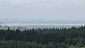 View of the Riverhead Forest looking south towards Auckland
 -
 Recently felled section of the Riverhead Forest
 -
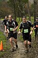 Trail runners competing in the XTerra Trail Run Series in 2009
 -
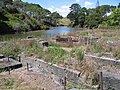 Remains of the Riverhead Forest mill


References edit
- ^ a b c d e f g h i j k l m n o p q r Lamb, Harriet (2001). "Riverhead: an Urban Forest". New Zealand Geographic. Archived from the original on 20 January 2021. Retrieved 11 March 2022.
- ^ "Auckland Climate" (PDF). National Institute of Water and Atmospheric Research. Archived (PDF) from the original on 23 May 2017. Retrieved 19 January 2018.
- ^ a b McClure, Margaret (1 August 2016). "Auckland places". Te Ara. Archived from the original on 4 November 2021. Retrieved 8 November 2021.
- ^ "About Us". World Challenge Tag. Archived from the original on 7 March 2022. Retrieved 11 March 2022.