


Summary
Roosevelt is a neighborhood in north Seattle, Washington. Its main thoroughfare, originally 10th Avenue, was renamed Roosevelt Way upon Theodore Roosevelt's death in 1919. The neighborhood received the name as the result of a Community Club contest held eight years later, in 1927.[1]
Roosevelt | |
|---|---|
 | |
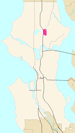 General location of Roosevelt (highlighted in pink) within Seattle | |
| Coordinates: 47°40′41″N 122°18′55″W / 47.67806°N 122.31528°W | |
| Country | United States |
| State | Washington |
| County | King |
| City | Seattle |
| Named for | Theodore Roosevelt |
| ZIP Code | 98115 |
| Area code | 206 |
Roosevelt's principal and minor arterials are the one-way pair Roosevelt Way (southbound) and 12th Avenue NE (northbound), Lake City Way (SR 522) and 15th Avenue NE, and NE 65th and 75th Streets.[2] City streets are laid out and designated in a pattern; see street layout of Seattle, directionals.
The boundaries of the neighborhood are Interstate 5 to the west, beyond which lies Green Lake; NE Ravenna Boulevard and NE 60th Street to the south, beyond which is the University District; 15th Avenue NE to the east, beyond which is Ravenna; and Lake City Way (SR 522) to the north, beyond which lies Maple Leaf.[3]
Schools edit
The Roosevelt district is also home to Roosevelt High School (RHS, opened 1922), one of the older schools in the Seattle Public Schools District. Like the street, it is named after Teddy, not Franklin D. Roosevelt.[1] For many years, Roosevelt High School and Garfield High School juggled the lead in the school district in many academic and sports fields. Alumni include Mark Pattison, who played football for the University of Washington Huskies and was drafted in the seventh round in 1985 by the Oakland Raiders of the NFL, actress Rose McGowan,(also attended Nova)[citation needed] and Nobel laureates Linda B. Buck and Robert Lucas Jr.[4]
Shops edit
Although primarily a residential neighborhood, the Roosevelt district had a Sears department store from 1928 to 1980.[5] After its closure, the land was redeveloped as Roosevelt Square,[1] which now features supermarket Whole Foods Market[6] and a Mud Bay pet store among other businesses. A block beyond Roosevelt Way to the west is the longest-established vegetarian restaurant in Seattle, independent Sunlight Cafe, nearly as old (1978) as Starbucks.[7] Numerous other small businesses still line 65th Street and Roosevelt Way. Teddy's is a multi-generational, multi-subculture popular biker bar. Roosevelt Way from 62nd Street north to 64th was somewhat of an "audio row", having featured a concentration of stores selling high-end audio and video systems and components. Today, only two such stores remain.
Parks edit
The neighborhood includes two parks: Cowen Park, in the southeast corner (contiguous with the larger Ravenna Park of Ravenna); and Froula Playground, in the northeast corner, adjacent to the Green Lake Reservoir. The source of Ravenna Creek has been reduced to Cowen Park; since completion of the partial daylighting in 2006, the creek has been reconnected to Lake Washington.
Transportation edit
The underground Roosevelt Link light rail station located at NE 65th St and 12th Ave NE opened for service on October 2, 2021, which connects Roosevelt to downtown Seattle as well as the Northgate neighborhood to the north.
The Roosevelt Light-Rail Station sparked remarkable growth in the area. During the nine-year transit construction period, the neighborhood transformed by replacing single-family homes with midrise apartments. Between 2016 and the opening of rail in 2021, there was a 95% increase in housing units, totaling 1,626 new residences.[8]
See also edit
Notes and references edit
- ^ a b c Wilma (20 August 2001)
- ^
"Street Arterial Classifications: Planning Maps" (PDF). Seattle Department of Transportation. 2004-01-12. Archived from the original (PDF) on 2006-06-22. Retrieved 2006-04-21.
Low-Resolution Version, PDF format, at "Principal, Minor and Collector arterials" Archived 2006-06-14 at the Wayback Machine, 2005
See Bibliography for map selection and links to definitions. - ^ (1) Wilma (20 August 2001).
(1.1) With respect to historical documentation, the Seattle City Clerk's Neighborhood Map Atlas has a discrepancy regarding the north boundary with Maple Leaf.
(2) Seattle City Clerk's Neighborhood Map Atlas (2002-06-17). ""Roosevelt", map". Office of the Seattle City Clerk. Retrieved 2006-04-21. Maps "NN-1030S", "NN-1040S".jpg dated 17 June 2002
(3) "About the Seattle City Clerk's On-line Information Services". Information Services. Seattle City Clerk's Office. 2006-04-30. Retrieved 2006-05-21.
See heading, "Note about limitations of these data".
(4) "About us". Roosevelt Neighborhood Association (RNA). Roosevelt Neighborhood Seattle. n.d. Retrieved 2006-06-24.
(4.1) RNA designation as official is for their non-profit 501(c)(3) corporation requirements. Since the abolition of wards in 1910, there exist no official neighborhoods or their boundaries in Seattle. [Wilma (1 May 2002, 28 September 2003)] - ^ (0) Unreferenced text: [citation needed] for Roosevelt-Garfield, for Pattison, and for McGowan.
(1) "The Nobel Prize in Physiology or Medicine 2004". Medicine > Laureates > Linda B. Buck. Nobelprize.org. 2004-04-10. Retrieved 2006-04-21.
(2) Buck as alumnus of RHS not found so far, [citation needed]; b. January 1947, graduated c. 1965.
(3) "The Bank of Sweden Prize in Economic Sciences in Memory of Alfred Nobel 1995". Economics > Laureates > Robert E. Lucas. Nobelprize.org. 2005-04-13. Retrieved 2006-04-21.
(4) Lucas is an alumnus of RHS, 1955 (Lucas in Frängsmyr, ed.). - ^ Sears Holding Corporation as of 2005 [Sears]
- ^ Warren.
- ^ (1) Eibel
(2) Beans and equipment since 1971, drinks since 1985, corporate expansion 1987. "Company Timeline: February 2006" (PDF). "the company. What we are all about". Starbucks. February 2006. Archived from the original (PDF) on 2007-08-10. Retrieved 2006-04-21.{{cite web}}: External link in|work= - ^ "Roosevelt light-rail station fuels rapid growth in North Seattle neighborhood". September 28, 2021.
External links edit
- Roosevelt Neighborhood Association official website
- Seattle City Clerk's Neighborhood Map Atlas — Roosevelt
Bibliography edit
- "About the Seattle City Clerk's On-line Information Services". Information Services. Seattle City Clerk's Office. 2006-04-30. Retrieved 2006-05-21.
- "About us". Roosevelt Neighborhood Association (RNA). Roosevelt Neighborhood Seattle. n.d. Retrieved 2006-06-24.
- "The Bank of Sweden Prize in Economic Sciences in Memory of Alfred Nobel 1995". Nobelprize.org. 2005-04-13. Retrieved 2006-04-21.
Economics > Laureates > Robert E. Lucas. - "Company Timeline: February 2006" (PDF). February 2006. Archived from the original (PDF) on 2007-08-10. Retrieved 2006-04-21.
PDF at "the company. What we are all about" - Eibel, E. (2000). "Sunlight Cafe: Seattle's Venerable Vegetarian Institution". Cheap Eats -E. Eibel. Retrieved 2006-04-21.
Howe > Restaurants > Vegetarian. - Lucas, Robert E. (1996). "Robert E. Lucas, Jr. – Autobiography". Title of Complete Work. Seattle Parks and Recreation. Archived from the original on 2006-05-07. Retrieved 2006-04-21.
From Frängsmyr, Tore, ed. (1996). Les Prix Nobel: The Nobel Prizes 1995. Stockholm: Nobel Foundation. - ""The Nobel Prize in Physiology or Medicine 2004", Medicine > Laureates > Linda B. Buck". Nobelprize.org. 2004-10-04. Retrieved 2006-04-21.
- "Street Classification Maps". Seattle Department of Transportation. 2005. Archived from the original on 2006-06-14. Retrieved 2006-04-21.
High-Resolution Version, PDF format, 16.1 MB
Medium-Resolution Version, PDF format, 1.45 MB 12 January 2004.
Low-Resolution Version, PDF format, 825 KB 12 January 2004.
"Planned Arterials Map Legend Definitions", PDF format. 12 January 2004.
The high resolution version is good for printing, 11 x 17. The low and medium resolution versions are good for quicker online viewing. [Source: "Street Classification Maps, Note on Accessing These PDF Files"] - "Roosevelt". Seattle City Clerk's Neighborhood Map Atlas. 2002-06-17. Retrieved 2006-04-21.
"NN-1030S", "NN-1040S".jpg dated 17 June 2002 - Warren, James R. (2004-09-13) [1999-09-16]. "Bartell, George H. Sr. (1868-1956)". Title of Complete Work. Seattle Parks and Recreation. Retrieved 2006-04-21.
- Wilma, David (2001-08-20). "Seattle Neighborhoods: Ravenna - Roosevelt – Thumbnail History". HistoryLink.org Essay 3502. Retrieved 2006-04-21.
- Wilma, David (2002-05-01). "Seattle voters reject a city manager and district elections on June 30, 1914". HistoryLink.org Essay 3761. Retrieved 2006-04-21.
- Wilma, David (2003-09-28). "Seattle voters reject district elections for city council on November 7, 1995". HistoryLink.org Essay 4246. Retrieved 2006-04-21.
- [1] Sound Transit webpage on future light rail station in Roosevelt
Further reading edit
- Walter, Sunny; local Audubon chapters (2006-02-10). "Sunny Walter's Washington Nature Weekends: Wildlife Viewing Locations - Greater Seattle Area". Archived from the original on 2005-03-22. Retrieved 2006-04-21.
"with additions by Sunny Walter and local Audubon chapters."
Viewing locations only; the book has walks, hikes, wildlife, and natural wonders.
Walter excerpted from- Dolan, Maria; True, Kathryn (2003). Nature in the city: Seattle. Seattle: Mountaineers Books. ISBN 0-89886-879-3. (paperback).
See "Northeast Seattle" section, bullet points "Meadowbrook", "Paramount Park Open Space", "North Seattle Community College Wetlands", and "Sunny Walter – Twin Ponds".
- Dolan, Maria; True, Kathryn (2003). Nature in the city: Seattle. Seattle: Mountaineers Books. ISBN 0-89886-879-3. (paperback).