


Summary
Rudnya (Russian: Ру́дня, Polish: Rudnia) is a town and the administrative center of Rudnyansky District in Smolensk Oblast, Russia, located on the Malaya Berezina River (Dnieper's basin) 68 kilometers (42 mi) northwest of Smolensk, the administrative center of the oblast. Population: 10,030 (2010 Russian census);[2] 9,853 (2002 Census);[8] 11,032 (1989 Soviet census).[9]
Rudnya
Рудня | |
|---|---|
 | |
 Coat of arms | |
Location of Rudnya .mw-parser-output .locmap .od{position:absolute}.mw-parser-output .locmap .id{position:absolute;line-height:0}.mw-parser-output .locmap .l0{font-size:0;position:absolute}.mw-parser-output .locmap .pv{line-height:110%;position:absolute;text-align:center}.mw-parser-output .locmap .pl{line-height:110%;position:absolute;top:-0.75em;text-align:right}.mw-parser-output .locmap .pr{line-height:110%;position:absolute;top:-0.75em;text-align:left}.mw-parser-output .locmap .pv>div{display:inline;padding:1px}.mw-parser-output .locmap .pl>div{display:inline;padding:1px;float:right}.mw-parser-output .locmap .pr>div{display:inline;padding:1px;float:left}html.skin-theme-clientpref-night .mw-parser-output .od,html.skin-theme-clientpref-night .mw-parser-output .od .pv>div,html.skin-theme-clientpref-night .mw-parser-output .od .pl>div,html.skin-theme-clientpref-night .mw-parser-output .od .pr>div{background:#000;color:#fff}html.skin-theme-clientpref-night .mw-parser-output .locmap{filter:grayscale(0.6)}@media(prefers-color-scheme:dark){html.skin-theme-clientpref-os .mw-parser-output .locmap{filter:grayscale(0.6)}html.skin-theme-clientpref-os .mw-parser-output .od,html.skin-theme-clientpref-os .mw-parser-output .od .pv>div,html.skin-theme-clientpref-os .mw-parser-output .od .pl>div,html.skin-theme-clientpref-os .mw-parser-output .od .pr>div{background:#000;color:#fff}}  Rudnya Location of Rudnya  Rudnya Rudnya (Smolensk Oblast) | |
| Coordinates: 54°57′N 31°06′E / 54.950°N 31.100°E | |
| Country | Russia |
| Federal subject | Smolensk Oblast[1] |
| Administrative district | Rudnyansky District[1] |
| Urban settlement | Rudnyanskoye[1] |
| First mentioned | 1363 |
| Town status since | 1926 |
| Area | |
| • Total | 14.99 km2 (5.79 sq mi) |
| Elevation | 190 m (620 ft) |
| Population | |
| • Total | 10,030 |
| • Estimate (2018)[3] | 9,484 (−5.4%) |
| • Density | 670/km2 (1,700/sq mi) |
| • Capital of | Rudnyansky District,[1] Rudnyanskoye Urban Settlement[1] |
| • Municipal district | Rudnyansky Municipal District[4] |
| • Urban settlement | Rudnyanskoye Urban Settlement[4] |
| • Capital of | Rudnyansky Municipal District,[4] Rudnyanskoye Urban Settlement[5] |
| Time zone | UTC+3 (MSK |
| Postal code(s)[7] | 216790, 216799 |
| OKTMO ID | 66638101001 |
History edit
Poland–Lithuania late 14th cent.–1569
Polish–Lithuanian Commonwealth 1569–1772
Russian Empire 1772–1917
Soviet Russia 1917–1922
Soviet Union 1922–1991
Rudnya (as the settlement of Rodnya) is first mentioned in 1363 since the lands were occupied by Andrei of Polotsk and included in the Principality of Smolensk.[10] During Polish rule it was part of the Vitebsk Voivodeship. After the First Partition of Poland in 1772 the area was included into newly established Babinovichsky Uyezd of Mogilev Governorate. In 1840, the uyezd was abolished and merged into Orshansky Uyezd of the same governorate.[11] In 1919, Mogilev Governorate was abolished, and Orshansky Uyezd was included into Gomel Governorate. In 1920, the uyezd was included into Vitebsk Governorate, and shortly the area was transferred to Smolensky Uyezd of Smolensk Governorate. In 1926, Rudnya was granted the town status.[11]
On 12 July 1929, governorates and uyezds were abolished, and Rudnyansky District with the administrative center in Rudnya was established. The district belonged to Smolensk Okrug of Western Oblast. On August 1, 1930, the okrugs were abolished, and the districts were subordinated directly to the oblast. On 27 September 1937 Western Oblast was abolished and split between Oryol and Smolensk Oblasts. Rudnyansky District was transferred to Smolensk Oblast. Between 1941 and September 1943, during World War II, the district was occupied by German troops.[10][12]
Rudnya is known as the maiden battle target of the famous Soviet multiple rocket launchers Katyusha. On July 14, 1941, an experimental artillery battery of seven launchers was first used in battle at Rudnya, under the command of Captain Ivan Flyorov, destroying a concentration of German troops with tanks, armored vehicles, and trucks at the marketplace, causing massive German Army casualties and its retreat from the town in panic.
Administrative and municipal status edit
Within the framework of administrative divisions, Rudnya serves as the administrative center of Rudnyansky District.[1] As an administrative division, it is incorporated within Rudnyansky District as Rudnyanskoye Urban Settlement.[1] As a municipal division, this administrative unit also has urban settlement status and is a part of Rudnyansky Municipal District.[4]
Economy edit
Industry edit
80% of the industrial production in Rudnyansky District is produced by food industry. There is also production of shoes and of doors and windows.[13]
Transportation edit
The railway connecting Smolensk with Vitebsk and further with Daugavpils passes Rudnya.
The R120 highway connecting Smolensk with the state border between Russia and Belarus, and continuing across the border to Vitebsk, passes Rudnya as well. The R130 highway connects Rudnya to Demidov.
Culture and recreation edit
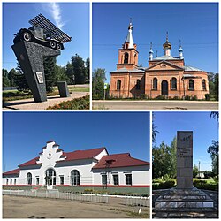
Rudnya contains a number of protected cultural heritage monuments, including the monument to the first Katyusha rocket launcher military usage during World War II in Rudnya.[14]
In Rudnya, there is a history museum[15] and a museum-house of Mikhail Yegorov.[16] The latter is a subdivision of Smolensk State Museum Reserve. Yegorov, who was born close to Rudnya, was one of the two Soviet soldiers who raised a flag over the Reichstag on 2 May 1945, after the Battle of Berlin.
Rudnya at one point had a Shtetl status, meaning that the village had a large concentration of Jews living in it. Jewish families first arrived after the Pale of Settlement was established in the western Russian Empire in 1791, granting Jews the legality to live in this settlement area. In 1926, there were 2235 Jews in Rudnya, nearly half of the village's population at the time. Many Jews in Rudnya moved to larger cities such as Leningrad and Smolensk in the early 1900s due to the newly established Communist driven industrial boom in larger cities. Of the nearly 2000 Jews who remained in the village during WWII, most were killed by the Nazis during the Holocaust after a ghetto was established in Rudnya. Local Jews were shot to death in several murder operations between 1941 and 1943.[17]
Geography edit
Climate edit
Rudnya has a warm-summer humid continental climate (Dfb in the Köppen climate classification).
| Climate data for Rudnya | |||||||||||||
|---|---|---|---|---|---|---|---|---|---|---|---|---|---|
| Month | Jan | Feb | Mar | Apr | May | Jun | Jul | Aug | Sep | Oct | Nov | Dec | Year |
| Mean daily maximum °C (°F) | −4.1 (24.6) |
−3.2 (26.2) |
2.4 (36.3) |
11.2 (52.2) |
17.2 (63.0) |
20.5 (68.9) |
22.9 (73.2) |
21.6 (70.9) |
16.0 (60.8) |
8.7 (47.7) |
2.7 (36.9) |
−1.3 (29.7) |
9.6 (49.2) |
| Daily mean °C (°F) | −6.1 (21.0) |
−5.8 (21.6) |
−1.1 (30.0) |
6.6 (43.9) |
13.0 (55.4) |
16.6 (61.9) |
19.0 (66.2) |
17.7 (63.9) |
12.4 (54.3) |
6.1 (43.0) |
1.0 (33.8) |
−3.0 (26.6) |
6.4 (43.5) |
| Mean daily minimum °C (°F) | −8.6 (16.5) |
−8.9 (16.0) |
−4.9 (23.2) |
1.4 (34.5) |
7.7 (45.9) |
11.7 (53.1) |
14.5 (58.1) |
13.4 (56.1) |
8.6 (47.5) |
3.5 (38.3) |
−0.9 (30.4) |
−5.0 (23.0) |
2.7 (36.9) |
| Average precipitation mm (inches) | 54 (2.1) |
49 (1.9) |
47 (1.9) |
47 (1.9) |
73 (2.9) |
83 (3.3) |
98 (3.9) |
83 (3.3) |
69 (2.7) |
69 (2.7) |
59 (2.3) |
53 (2.1) |
784 (31) |
| Source: https://en.climate-data.org/asia/russian-federation/smolensk-oblast/rudnya-37333/ | |||||||||||||
References edit
Notes edit
- ^ a b c d e f g h i Resolution #261
- ^ a b Russian Federal State Statistics Service (2011). Всероссийская перепись населения 2010 года. Том 1 [2010 All-Russian Population Census, vol. 1]. Всероссийская перепись населения 2010 года [2010 All-Russia Population Census] (in Russian). Federal State Statistics Service.
- ^ Error: Unable to display the reference properly. See the documentation for details.
- ^ a b c d Law #76-z
- ^ Федеральная служба государственной статистики. Федеральное агентство по технологическому регулированию и метрологии. №ОК 033-2013 1 января 2014 г. «Общероссийский классификатор территорий муниципальных образований. Код 66 638 101». (Federal State Statistics Service. Federal Agency on Technological Regulation and Metrology. #OK 033-2013 January 1, 2014 Russian Classification of Territories of Municipal Formations. Code 66 638 101. ).
- ^ "Об исчислении времени". Официальный интернет-портал правовой информации (in Russian). June 3, 2011. Retrieved January 19, 2019.
- ^ Почта России. Информационно-вычислительный центр ОАСУ РПО. (Russian Post). Поиск объектов почтовой связи (Postal Objects Search) (in Russian)
- ^ Federal State Statistics Service (May 21, 2004). Численность населения России, субъектов Российской Федерации в составе федеральных округов, районов, городских поселений, сельских населённых пунктов – районных центров и сельских населённых пунктов с населением 3 тысячи и более человек [Population of Russia, Its Federal Districts, Federal Subjects, Districts, Urban Localities, Rural Localities—Administrative Centers, and Rural Localities with Population of Over 3,000] (XLS). Всероссийская перепись населения 2002 года [All-Russia Population Census of 2002] (in Russian).
- ^ Всесоюзная перепись населения 1989 г. Численность наличного населения союзных и автономных республик, автономных областей и округов, краёв, областей, районов, городских поселений и сёл-райцентров [All Union Population Census of 1989: Present Population of Union and Autonomous Republics, Autonomous Oblasts and Okrugs, Krais, Oblasts, Districts, Urban Settlements, and Villages Serving as District Administrative Centers]. Всесоюзная перепись населения 1989 года [All-Union Population Census of 1989] (in Russian). Институт демографии Национального исследовательского университета: Высшая школа экономики [Institute of Demography at the National Research University: Higher School of Economics]. 1989 – via Demoscope Weekly.
- ^ a b История (in Russian). Rudnyansky District Administration. Retrieved October 10, 2016.
{{cite web}}: Check|url=value (help) - ^ a b Герб Руднянского района (in Russian). City of Roslavl. Retrieved October 10, 2016.
- ^ Борис Парфенов; Ольга Хоренженкова. К истории формирования Смоленской области (in Russian). Смоленск. Archived from the original on May 31, 2016. Retrieved June 18, 2016.
- ^ Промышленность (in Russian). Rudnyansky District Administration. Retrieved October 2, 2016.
{{cite web}}: Check|url=value (help) - ^ "На пьедестале - "КАТЮША"" (in Russian). Administration of Rudnyansky District.
{{cite web}}: Check|url=value (help) - ^ Муниципальное бюджетное учреждение культуры Руднянский исторический музей (in Russian). Rudnya History Museum. Retrieved October 7, 2016.
- ^ Дом-музей М.А.Егорова (in Russian). Смоленский государственный музей-заповедник. Retrieved October 7, 2016.
- ^ "YV360".
Sources edit
- Администрация Смоленской области. Постановление №261 от 30 апреля 2008 г. «Об утверждении реестра административно-территориальных единиц и территориальных единиц Смоленской области», в ред. Постановления №464 от 27 июня 2014 г. «О внесении изменений в реестр административно-территориальных единиц и территориальных единиц Смоленской области». Опубликован: База данных "Консультант-плюс". (Administration of Smolensk Oblast. Resolution #261 of April 30, 2008 On the Adoption of the Registry of the Administrative-Territorial Units and Territorial Units of Smolensk Oblast, as amended by the Resolution #464 of June 27, 2014 On Amending the Registry of the Administrative-Territorial Units and Territorial Units of Smolensk Oblast. ).
- Смоленская областная Дума. Закон №76-з от 1 декабря 2004 г. «О наделении статусом муниципального района муниципального образования Руднянский район Смоленской области, об установлении границ муниципальных образований, территории которых входят в его состав, и наделении их соответствующим статусом», в ред. Закона №111-з от 23 ноября 2011 г. «О внесении изменений в областной Закон "О наделении статусом муниципального района муниципального образования Руднянский район Смоленской области, об установлении границ муниципальных образований, территории которых входят в его состав, и наделении их соответствующим статусом"». Вступил в силу со дня официального опубликования. Опубликован: "Вестник Смоленской областной Думы и Администрации Смоленской области", №12, часть II, стр. 104, 5 декабря 2004 г. (Smolensk Oblast Duma. Law #76-z of December 1, 2004 On Granting the Status of the Municipal District to the Municipal Formation of Rudnyansky District of Smolensk Oblast, on Establishing the Borders of the Municipal Formations Whose Territories It Comprises, and on Granting Them Appropriate Status, as amended by the Law #111-z of November 23, 2011 On Amending the Oblast Law "On Granting the Status of the Municipal District to the Municipal Formation of Rudnyansky District of Smolensk Oblast, on Establishing the Borders of the Municipal Formations Whose Territories It Comprises, and on Granting Them Appropriate Status". Effective as of the official publication date.).
External links edit
- The murder of the Jews of Rudnya during World War II, at Yad Vashem website.