
-
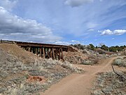
 Santa Fe Depot, with a Rail Runner Express train (right), alongside a diesel locomotive and ex-Santa Fe Pleasure Dome operated by the SFSR
 -
 One of many trestle bridges along the trail. Here the trail has improved natural surface
 -
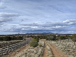
 Asphalted section near I-25

KNOWPIA
WELCOME TO KNOWPIA
Santa Fe Rail Trail 
Summary
The Santa Fe Rail Trail is a multi-use trail, part of the trail system in the city of Santa Fe, New Mexico. The trail begins at the Santa Fe Depot, in the Railyard arts district, and ends at U.S. Route 285, near Lamy, New Mexico and the Lamy station. An example of Rails with trails, it parallels the New Mexico Rail Runner Express tracks to roughly I-25, where it then continues along the Santa Fe Southern Railway. The Santa Fe Rail trail is 15 miles long, is asphalted for the first 3.5 miles, and improved natural surface for 11.5 miles. The last few miles between Eldorado and US-285 is unimproved natural surface.
| Santa Fe Rail Trail | |
|---|---|
 View of the Sangre de Cristo Mountains | |
| Length | 15 mi (24 km)[1] |
| Location | Santa Fe, New Mexico, United States |
| Established | July 2010[1] |
| Trailheads | Zia Road Rabbit Road Nine Mile Road Avenida Vista Grande Avenida Eldorado Highway 285 |
| Use | Commuting, Hiking, Trail running, Mountain Biking |
| Season | All year |
| Hazards | Dehydration |
| Surface | paved, natural |
Trailheads, crossings and access edit
Santa Fe Rail Trail | |||||||||||||||||||||||||||||||||||||||||||||||||||||||||||||||||||||||||||||||||||||||||||||||||||||||||||||||||||||||||||||||||||||||||||||||||||||||||||||||||||||||||||||||||||||||||||||||||||||||||||||||||||||||||||||||||||||||||||||||||||||||||||||||||||||||||||||||||||||||||||||||||||||||||||||||||||||||||||||||||||||||||
|---|---|---|---|---|---|---|---|---|---|---|---|---|---|---|---|---|---|---|---|---|---|---|---|---|---|---|---|---|---|---|---|---|---|---|---|---|---|---|---|---|---|---|---|---|---|---|---|---|---|---|---|---|---|---|---|---|---|---|---|---|---|---|---|---|---|---|---|---|---|---|---|---|---|---|---|---|---|---|---|---|---|---|---|---|---|---|---|---|---|---|---|---|---|---|---|---|---|---|---|---|---|---|---|---|---|---|---|---|---|---|---|---|---|---|---|---|---|---|---|---|---|---|---|---|---|---|---|---|---|---|---|---|---|---|---|---|---|---|---|---|---|---|---|---|---|---|---|---|---|---|---|---|---|---|---|---|---|---|---|---|---|---|---|---|---|---|---|---|---|---|---|---|---|---|---|---|---|---|---|---|---|---|---|---|---|---|---|---|---|---|---|---|---|---|---|---|---|---|---|---|---|---|---|---|---|---|---|---|---|---|---|---|---|---|---|---|---|---|---|---|---|---|---|---|---|---|---|---|---|---|---|---|---|---|---|---|---|---|---|---|---|---|---|---|---|---|---|---|---|---|---|---|---|---|---|---|---|---|---|---|---|---|---|---|---|---|---|---|---|---|---|---|---|---|---|---|---|---|---|---|---|---|---|---|---|---|---|---|---|---|---|---|---|---|---|---|---|---|---|---|---|---|---|---|---|---|---|---|---|---|---|---|---|---|---|---|---|---|---|---|---|---|---|---|---|---|---|---|---|
| |||||||||||||||||||||||||||||||||||||||||||||||||||||||||||||||||||||||||||||||||||||||||||||||||||||||||||||||||||||||||||||||||||||||||||||||||||||||||||||||||||||||||||||||||||||||||||||||||||||||||||||||||||||||||||||||||||||||||||||||||||||||||||||||||||||||||||||||||||||||||||||||||||||||||||||||||||||||||||||||||||||||||
The Santa Fe Rail Trail can be accessed via trailheads, connecting trails, and intersecting roadways in Santa Fe and Eldorado. The New Mexico Rail Runner Express has stops on the trail at the Santa Fe Depot, South Capitol station, and Zia Road station. Major connecting trails are the Arroyo de los Chamisos Trail (paved), the Spur Trail (improved natural surface), and Galisteo Basin trail system.
| Access | Milepost | Directions | Map Coordinates |
|---|---|---|---|
| Santa Fe Depot | 0 | 410 South Guadalupe Street | 35°41′03″N 105°56′48″W / 35.68417°N 105.94667°W |
| South Capitol station | 1 mi (1.6 km) | 1301 Alta Vista | 35°40′23″N 105°57′26″W / 35.67306°N 105.95722°W |
| Siringo Road crossing | 2.7 mi (4.3 km) | connecting Arroyo de los Chamisos Trail | |
| Zia Road station | 3.4 mi (5.5 km) | 602 West Zia Road, parking available | 35°38′47″N 105°57′25″W / 35.6464°N 105.9570°W |
| Rodeo Road crossing | 4.2 mi (6.8 km) | Rodeo Rd and Siringo | |
| Rabbit Road Trailhead | 5.0 mi (8.0 km) | 249-251 Rabbit Rd., parking available | 35°37′40″N 105°58′01″W / 35.62771°N 105.96681°W |
| Spur Trail | 6.7 mi (10.8 km) | connecting trail from Santa Fe Community College and | |
| Nine Mile Trailhead | 8.8 mi (14.2 km) | parking available | |
| Avenida Vista Grande | 11.8 mi (19.0 km) | in Eldorado | |
| Avenida Eldorado | 13.4 mi (21.6 km) | in Eldorado, parking available | |
| Spur Ranch Road | 14.9 mi (24.0 km) | ||
| US-285 Trailhead | 16.7 mi (26.9 km) |


Gail Ryba Trail edit
Small asphalted branch trail that connects the Rail Trail to shopping areas, neighborhoods, and a medical center. The Gail Ryba Trail starts at Saint Michaels near the Hospital, joins the rail trail thru an underpass at Saint Francis Drive, and ends at West Zia Road. Approximately 1 mile long.
Spur Trail edit
Improved natural surface trail that branches from the rail trail to connect to the Santa Fe Community College. The Spur Trail trailhead is located at the intersection of Richards Avenue and Avenida del Sur ( 35°35′56″N 106°00′05″W / 35.5988°N 106.0014°W ). Approximately 3 miles long.[2]
References edit
External links edit
- City of Santa Fe - Trails & Maps
- Santa Fe Conservation Trust
- SANTA FE METROPOLITAN PLANNING ORGANIZATION
- newspaper article about segment 2 in the Santa Fe New Mexican