


Summary
Solana, officially the Municipality of Solana (Ibanag: Ili nat Solana; Itawit: Ili yo Solana; Ilocano: Ili ti Solana; Tagalog: Bayan ng Solana), is a 1st class municipality in the province of Cagayan, Philippines. According to the 2020 census, it has a population of 88,445 people.[3]
Solana | |
|---|---|
| Municipality of Solana | |
 Solana Municipal Hall | |
 Flag  Seal | |
 Map of Cagayan with Solana highlighted | |
OpenStreetMap .mw-parser-output .locmap .od{position:absolute}.mw-parser-output .locmap .id{position:absolute;line-height:0}.mw-parser-output .locmap .l0{font-size:0;position:absolute}.mw-parser-output .locmap .pv{line-height:110%;position:absolute;text-align:center}.mw-parser-output .locmap .pl{line-height:110%;position:absolute;top:-0.75em;text-align:right}.mw-parser-output .locmap .pr{line-height:110%;position:absolute;top:-0.75em;text-align:left}.mw-parser-output .locmap .pv>div{display:inline;padding:1px}.mw-parser-output .locmap .pl>div{display:inline;padding:1px;float:right}.mw-parser-output .locmap .pr>div{display:inline;padding:1px;float:left}html.skin-theme-clientpref-night .mw-parser-output .od,html.skin-theme-clientpref-night .mw-parser-output .od .pv>div,html.skin-theme-clientpref-night .mw-parser-output .od .pl>div,html.skin-theme-clientpref-night .mw-parser-output .od .pr>div{background:#000;color:#fff}html.skin-theme-clientpref-night .mw-parser-output .locmap{filter:grayscale(0.6)}@media(prefers-color-scheme:dark){html.skin-theme-clientpref-os .mw-parser-output .locmap{filter:grayscale(0.6)}html.skin-theme-clientpref-os .mw-parser-output .od,html.skin-theme-clientpref-os .mw-parser-output .od .pv>div,html.skin-theme-clientpref-os .mw-parser-output .od .pl>div,html.skin-theme-clientpref-os .mw-parser-output .od .pr>div{background:#000;color:#fff}}  Solana Location within the Philippines | |
| Coordinates: 17°39′08″N 121°41′29″E / 17.6522°N 121.6914°E | |
| Country | Philippines |
| Region | Cagayan Valley |
| Province | Cagayan |
| District | 3rd district |
| Barangays | 38 (see Barangays) |
| Government | |
| • Type | Sangguniang Bayan |
| • Mayor | Jennalyn P. Carag |
| • Vice Mayor | Meynard Z. Carag, CPA |
| • Representative | Joseph L. Lara |
| • Municipal Council | Members |
| • Electorate | 49,201 voters (2022) |
| Area | |
| • Total | 234.60 km2 (90.58 sq mi) |
| Elevation | 34 m (112 ft) |
| Highest elevation | 153 m (502 ft) |
| Lowest elevation | 12 m (39 ft) |
| Population (2020 census)[3] | |
| • Total | 88,445 |
| • Density | 380/km2 (980/sq mi) |
| • Households | 21,407 |
| Economy | |
| • Income class | 1st municipal income class |
| • Poverty incidence | 10.72 |
| • Revenue | ₱ 282 million (2020) |
| • Assets | ₱ 857.2 million (2020) |
| • Expenditure | ₱ 246.7 million (2020) |
| • Liabilities | ₱ 274.3 million (2020) |
| Service provider | |
| • Electricity | Cagayan 1 Electric Cooperative (CAGELCO 1) |
| Time zone | UTC+8 (PST) |
| ZIP code | 3503 |
| PSGC | 021527000 |
| IDD : area code | +63 (0)78 |
| Native languages | Ibanag Ilocano Itawis Tagalog |
| Website | www |
Solana is a first class municipality covering an area of 277.22 square kilometers with 38 barangays. The Municipality is surrounded by the following: on the east by the Cagayan River, bounded on the north by the Municipality of Amulung, on the south by the Municipality of Enrile, on the southwest by the Province of Kalinga and on the northwest by the Municipalities of Piat and Tuao. Solana is 11 kilometres (6.8 mi) from Tuguegarao and 492 kilometres (306 mi) from Manila.
The Awidon Mesa Formationa Paleolithic Sites of the municipality, along with the Callao Limestone Formation Paleolithic Sites neighboring Penablanca, are included in the tentative list of the Philippines for future UNESCO World Heritage Site inscription under the name of Paleolithic Archaeological Sites in Cagayan Valley. The Awidon Mesa Formation has at least 68 Paleolithic sites which yielded stone tools and fossils of extinct animals that include stegodons, elephants, rhinoceros, and large tortoise.
History edit
Formerly part of Tuguegarao, Solana was formally made an independent town on 18 August 1852. It was named after Governor General Juan Antonio de Urbiztondo, Marquis of La Solana.[5] Prior to that it was called Marague, after a rich widower named Francisco Marague who settled in the area and built a stone house. During the Second World War, the barrio of Andarayan was bombed by American planes on 13 June 1945, killing 50 people.[6]
Geography edit
Topography edit
Solana is mostly flat with mountainous terrain on the central area from Barangay Madarallug going north to Barangay Iraga due to the Barung Anticline and Liwan Syncline.
The municipality is bounded by the Cagayan River to the East, Amulung to the North, Enrile to the South and Municipality of Tuao and Piat to the West.
With its proximity in the Cagayan River, it is usually flooded during typhoon season where the river is usually swollen thus providing a fluvial soil good for farming.
Barangays edit
Solana is politically subdivided into 38 barangays. Each barangay consists of puroks while some have sitios.
- Andarayan North
- Andarayan South
- Bangag
- Bantay
- Basi East
- Basi West
- Bauan East
- Bauan West
- Cadaanan
- Calamagui
- Calillauan
- Carilucud
- Cattaran
- Centro Northeast (Poblacion)
- Centro Northwest (Poblacion)
- Centro Southeast (Poblacion)
- Centro Southwest (Poblacion)
- Dassun
- Furagui
- Gadu
- Gen. Eulogio Balao
- Iraga
- Lanna
- Lannig
- Lingu
- Maddarulug (Santo Domingo)
- Maguirig
- Malalam-Malacabibi
- Nabbotuan
- Nangalisan
- Natappian East
- Natappian West
- Padul
- Palao
- Parug-parug
- Pataya
- Sampaguita
- Ubong
Climate edit
Just like the general climatic conditions of the Philippines, the municipality of Solana's climate is tropical and maritime. It is characterized by relatively high temperature, high humidity and abundant rainfall.
[7] Based from the Climate Map of PAGASA, the municipality belongs to the Type III Climate with no very pronounced maximum rain period with a dry season lasting only from one to three monthse either from December to February or from March to May.
| Climate data for Solana, Cagayan | |||||||||||||
|---|---|---|---|---|---|---|---|---|---|---|---|---|---|
| Month | Jan | Feb | Mar | Apr | May | Jun | Jul | Aug | Sep | Oct | Nov | Dec | Year |
| Mean daily maximum °C (°F) | 25 (77) |
26 (79) |
28 (82) |
31 (88) |
32 (90) |
31 (88) |
31 (88) |
30 (86) |
30 (86) |
28 (82) |
27 (81) |
25 (77) |
29 (84) |
| Mean daily minimum °C (°F) | 21 (70) |
21 (70) |
22 (72) |
23 (73) |
24 (75) |
25 (77) |
24 (75) |
25 (77) |
24 (75) |
23 (73) |
23 (73) |
22 (72) |
23 (74) |
| Average precipitation mm (inches) | 155 (6.1) |
113 (4.4) |
89 (3.5) |
58 (2.3) |
127 (5.0) |
131 (5.2) |
154 (6.1) |
184 (7.2) |
151 (5.9) |
247 (9.7) |
221 (8.7) |
292 (11.5) |
1,922 (75.6) |
| Average rainy days | 19.6 | 14.8 | 13.4 | 12.0 | 19.4 | 19.8 | 23.0 | 25.0 | 23.0 | 19.4 | 19.1 | 21.6 | 230.1 |
| Source: Meteoblue[8] | |||||||||||||
Demographics edit
|
| |||||||||||||||||||||||||||||||||||||||||||||||||||
| Source: Philippine Statistics Authority[9][10][11][12] | ||||||||||||||||||||||||||||||||||||||||||||||||||||
In the 2020 census, the population of Solana, Cagayan, was 88,445 people,[3] with a density of 380 inhabitants per square kilometre or 980 inhabitants per square mile.
Economy edit
Government edit
Local government edit
Solana, belonging to the third legislative district of the province of Cagayan, is governed by a mayor designated as its local chief executive and by a municipal council as its legislative body in accordance with the Local Government Code. The Sangguniang Bayan is composed of the (Municipality) Vice Mayor as Presiding Officer, regular Sanggunian members (Councilors), the President of the Association of Barangay Captains and the President of the Sangguniang Kabataan. They shall exercise and perform the legislative powers and duties as provided for under Republic Act No. 7160, otherwise known as the Local Government Code of 1991. Shall consider and conduct thorough study all matters brought to their attention and consequently pass resolutions, enact ordinances and to introduce recommendations.[20]
Elected officials edit
| Position | Name |
|---|---|
| Congressman | Joseph L. Lara |
| Mayor | Jennalyn P. Carag |
| Vice-Mayor | Meynard Z. Carag, CPA |
| Councilors | Francsica F. de Asis |
| Atty. Carlo Paolo G. Lasam | |
| Amelia P. Carag | |
| James C. Mallillin | |
| Ronald C. Cristobal | |
| Edilberto A. Edillo | |
| Angelina L. Fernandez | |
| Atty. Domingo A. Lagundi Jr. |
Elected officials edit
| Position | Name |
|---|---|
| Congressman | Joseph L. Lara |
| Mayor | Jennalyn P. Carag |
| Vice-Mayor | Meynard Z. Carag, CPA |
| Councilors | Ronald C. Cristobal |
| Edilberto A. Edillo | |
| James C. Mallillin | |
| Francisca F. De Asis | |
| Atty. Carlo Paolo G. Lasam | |
| Angelina L. Fernandez | |
| All B. Ubina | |
| Amelia P. Carag |
Education edit

The Schools Division of Cagayan governs the town's public education system. [22]
It is also in Solana where the SDO office transfer its location after it the division office building located near the Boy Scout of the Philippines – Cagayan Chapter Office and the Cagayan National High School was razed by fire on August 10, 2012. Immediately on the following day, the Office of the Division of Cagayan was temporarily transferred to the defunct DPWH Building at Lingu, Solana, Cagayan until November 15, 2017.[23]
The division office is a field office of the DepEd in Cagayan Valley region.[24] The office governs the public and private elementary and public and private high schools throughout the municipality.
Solana is currently divided into 3 district namely Solana North, Solana South and Solana West Educational Zone. According to SDO Cagayan, it has 10 public elementary schools in Solana North, 10 public elementary in Solana South and 14 in Solana West Educational Zone[25]
The High school students from the Municipality is also catered by 6 public secondary schools namely Solana Freshwater Fisheries School, Dassun NHS, Andarayan NHS, Solana NHS, Gadu NHS and Sampaguita NHS.
The only Catholic School that serves the area is Saint Vincent Ferrer Institute (SVI) under Saint Vincent Ferrer Parish which offers basic education from elementary to senior high school.
Cagayan State University has also established another campus in the area. By the virtue of Republic Act 11858,[26] the extension campus was converted into a regular campus to be known at Cagayan State University - Solana Campus. The said higher education institution will offer academic programs in Teacher Education, Agriculture, Fisheries, Information and Computing Sciences, and Criminology.
Gallery edit
-
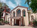 Old Solana Church
 -
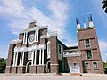 New Solana Church
 -
 Solana Public Market
 -
 Solana Junction


References edit
- ^ Municipality of Solana | (DILG)
- ^ "2015 Census of Population, Report No. 3 – Population, Land Area, and Population Density" (PDF). Philippine Statistics Authority. Quezon City, Philippines. August 2016. ISSN 0117-1453. Archived (PDF) from the original on May 25, 2021. Retrieved July 16, 2021.
- ^ a b c Census of Population (2020). "Region II (Cagayan Valley)". Total Population by Province, City, Municipality and Barangay. Philippine Statistics Authority. Retrieved July 8, 2021.
- ^ "PSA Releases the 2018 Municipal and City Level Poverty Estimates". Philippine Statistics Authority. December 15, 2021. Retrieved January 22, 2022.
- ^ Salgado, Pedro. "Other Missions in Cagayan Province". Cagayan Valley and Easter Cordillera: 1581-1898, Volume I. Rex Publishing. p. 340.
- ^ de Rivera Castillet, Ed. Cagayan Province and her People. Community Publishers.
- ^ "Climate of the Philippines".
- ^ "Solana, Cagayan: Average Temperatures and Rainfall". Meteoblue. Retrieved December 27, 2018.
- ^ Census of Population (2015). "Region II (Cagayan Valley)". Total Population by Province, City, Municipality and Barangay. Philippine Statistics Authority. Retrieved June 20, 2016.
- ^ Census of Population and Housing (2010). "Region II (Cagayan Valley)" (PDF). Total Population by Province, City, Municipality and Barangay. National Statistics Office. Retrieved June 29, 2016.
- ^ Censuses of Population (1903–2007). "Region II (Cagayan Valley)". Table 1. Population Enumerated in Various Censuses by Province/Highly Urbanized City: 1903 to 2007. National Statistics Office.
{{cite encyclopedia}}: CS1 maint: numeric names: authors list (link) - ^ "Province of Cagayan". Municipality Population Data. Local Water Utilities Administration Research Division. Retrieved December 17, 2016.
- ^ "Poverty incidence (PI):". Philippine Statistics Authority. Retrieved December 28, 2020.
- ^ "Estimation of Local Poverty in the Philippines" (PDF). Philippine Statistics Authority. November 29, 2005.
- ^ "2003 City and Municipal Level Poverty Estimates" (PDF). Philippine Statistics Authority. March 23, 2009.
- ^ "City and Municipal Level Poverty Estimates; 2006 and 2009" (PDF). Philippine Statistics Authority. August 3, 2012.
- ^ "2012 Municipal and City Level Poverty Estimates" (PDF). Philippine Statistics Authority. May 31, 2016.
- ^ "Municipal and City Level Small Area Poverty Estimates; 2009, 2012 and 2015". Philippine Statistics Authority. July 10, 2019.
- ^ "PSA Releases the 2018 Municipal and City Level Poverty Estimates". Philippine Statistics Authority. December 15, 2021. Retrieved January 22, 2022.
- ^ "The Local Government Code of the Philippines. Book III: Local Government Units" (PDF). Government of the Philippines. Retrieved September 18, 2016.
 This article incorporates text from this source, which is in the public domain.
- ^ "2019 National and Local Elections" (PDF). Commission on Elections. Retrieved March 10, 2022.
- ^ "History of DepED SDO Cagayan". DepED SDO Cagayan | Official Website of DepED SDO Cagayan. Retrieved March 13, 2022.
- ^ "History of DepEd SDO Cagayan". This article incorporates text from this source, which is in the public domain.
- ^ "DEPED REGIONAL OFFICE NO. 02". DepED RO2 | The official website of DepED Regional Office No. 02.
- ^ "SDO Cagayan Public Elementary Schools".
- ^ "Republic Act No. 11858 | GOVPH".
External links edit
- Philippine Standard Geographic Code
- Philippine Census Information