


Summary
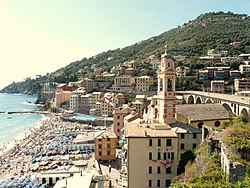
Sori (Ligurian: Söi) is a comune (municipality) in the Metropolitan City of Genoa in the Italian region Liguria, located about 17 kilometres (11 mi) southeast of Genoa. Together with Camogli, Pieve Ligure, Bogliasco, and Recco, it is part of the so-called Golfo Paradiso in the Riviera di Levante. Its economy is based on tourism and production of olives.
Sori
Söi | |
|---|---|
| Comune di Sori | |
 | |
Location of Sori .mw-parser-output .locmap .od{position:absolute}.mw-parser-output .locmap .id{position:absolute;line-height:0}.mw-parser-output .locmap .l0{font-size:0;position:absolute}.mw-parser-output .locmap .pv{line-height:110%;position:absolute;text-align:center}.mw-parser-output .locmap .pl{line-height:110%;position:absolute;top:-0.75em;text-align:right}.mw-parser-output .locmap .pr{line-height:110%;position:absolute;top:-0.75em;text-align:left}.mw-parser-output .locmap .pv>div{display:inline;padding:1px}.mw-parser-output .locmap .pl>div{display:inline;padding:1px;float:right}.mw-parser-output .locmap .pr>div{display:inline;padding:1px;float:left}html.skin-theme-clientpref-night .mw-parser-output .od,html.skin-theme-clientpref-night .mw-parser-output .od .pv>div,html.skin-theme-clientpref-night .mw-parser-output .od .pl>div,html.skin-theme-clientpref-night .mw-parser-output .od .pr>div{background:#000;color:#fff}html.skin-theme-clientpref-night .mw-parser-output .locmap{filter:grayscale(0.6)}@media(prefers-color-scheme:dark){html.skin-theme-clientpref-os .mw-parser-output .locmap{filter:grayscale(0.6)}html.skin-theme-clientpref-os .mw-parser-output .od,html.skin-theme-clientpref-os .mw-parser-output .od .pv>div,html.skin-theme-clientpref-os .mw-parser-output .od .pl>div,html.skin-theme-clientpref-os .mw-parser-output .od .pr>div{background:#000;color:#fff}}  Sori Location of Sori in Italy  Sori Sori (Liguria) | |
| Coordinates: 44°22′22″N 9°6′16″E / 44.37278°N 9.10444°E | |
| Country | Italy |
| Region | Liguria |
| Metropolitan city | Genoa (GE) |
| Frazioni | Canepa, Capreno, Lago, Levà, Polanesi, San Bartolomeo di Busonengo, Sant’Apollinare, Sussisa, Teriasca |
| Government | |
| • Mayor | Mario Reffo |
| Area | |
| • Total | 13.07 km2 (5.05 sq mi) |
| Elevation | 14 m (46 ft) |
| Population (31 May 2022)[2] | |
| • Total | 4,003 |
| • Density | 310/km2 (790/sq mi) |
| Demonym | Soresi |
| Time zone | UTC+1 (CET) |
| • Summer (DST) | UTC+2 (CEST) |
| Postal code | 16031 |
| Dialing code | 0185 |
| Patron saint | Santa Margherita d'Antiochia |
| Saint day | July 20 |
| Website | Official website |

The municipality of Sori contains the frazioni (subdivisions, mainly villages and hamlets) Canepa, Capreno, Lago, Levà, Polanesi, San Bartolomeo di Busonengo, Sant’Apollinare, Sussisa, and Teriasca.
Sori borders the following municipalities: Avegno, Bargagli, Bogliasco, Genoa, Lumarzo, Pieve Ligure, Recco, and Uscio.
History edit
According to some theories, Sori was founded by Greek immigrants around the 7th century BC. Most likely, the small port was also used by the Romans, although the first mention of the town dates to the early Middle Ages, when it was a possession of the bishops of Milan; later, it was part of the Republic of Genoa.
In 1584, the town was sacked and ravaged by 1500 pirates from North Africa.[3] After the French domination in 1815, Sori became part of the Kingdom of Sardinia and, from 1861, was part of the unified Kingdom of Italy.
References edit
- ^ "Superficie di Comuni Province e Regioni italiane al 9 ottobre 2011". Italian National Institute of Statistics. Retrieved 16 March 2019.
- ^ All demographics and other statistics: Italian statistical institute Istat.
- ^ Kirk, Thomas Allison (2013-01-03). Genoa and the Sea: Policy and Power in an Early Modern Maritime Republic, 1559–1684. JHU Press. ISBN 978-1-4214-0966-5.
External links edit
- Official website
- Collection of images of Sori